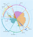
Soubor:Antarctica, territorial claims.svg
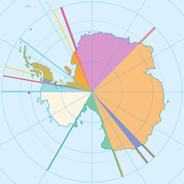
Velikost tohoto PNG náhledu tohoto SVG souboru: 600 × 600 pixelů. Jiná rozlišení: 240 × 240 pixelů | 480 × 480 pixelů | 768 × 768 pixelů | 1 024 × 1 024 pixelů | 2 048 × 2 048 pixelů | 820 × 820 pixelů.
Původní soubor (soubor SVG, nominální rozměr: 820 × 820 pixelů, velikost souboru: 72 KB)
Historie souboru
Kliknutím na datum a čas se zobrazí tehdejší verze souboru.
| Datum a čas | Náhled | Rozměry | Uživatel | Komentář | |
|---|---|---|---|---|---|
| současná | 8. 5. 2020, 18:42 |  | 820 × 820 (72 KB) | Spesh531 | Norway's claim stretches to the South Pole as of June 12 2015 |
| 13. 10. 2009, 06:31 |  | 820 × 820 (71 KB) | DooFi | sauerkraut | |
| 30. 6. 2008, 22:08 |  | 806 × 806 (43 KB) | Lokal Profil | {{Information |Description={{en|Map showing the territorial claims to Antarctica}} {{legend|#e987eb|New Zealand}} {{legend|#fcc475|Australia}} {{legend|#8282ed|France}} {{legend|#7efa72|Norway}} {{legend|#ec787f|United Kingdom}} {{legend|#6db87f|Chile}} { |
Využití souboru
Tento soubor používají následující 3 stránky:
Globální využití souboru
Tento soubor využívají následující wiki:
- Využití na af.wikipedia.org
- Využití na ar.wikipedia.org
- Využití na ast.wikipedia.org
- Využití na az.wikipedia.org
- Využití na bn.wikipedia.org
- Využití na de.wikipedia.org
- Využití na en.wikipedia.org
- Využití na es.wikipedia.org
- Využití na eu.wikipedia.org
- Využití na fa.wikipedia.org
- Využití na frr.wikipedia.org
- Využití na fy.wikipedia.org
- Využití na gl.wikipedia.org
- Využití na hu.wikipedia.org
- Využití na hy.wikipedia.org
- Využití na id.wikipedia.org
- Využití na ilo.wikipedia.org
- Využití na it.wikipedia.org
Zobrazit další globální využití tohoto souboru.


