
Soubor:Inland empire within southern california.png
Větší rozlišení není k dispozici
Inland_empire_within_southern_california.png (342 × 308 pixelů, velikost souboru: 160 KB, MIME typ: image/png)
| Tento soubor pochází z Wikimedia Commons. Níže jsou zobrazeny informace, které obsahuje jeho tamější stránka s popisem souboru. |
Popis
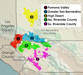
English: The Inland Empire metropolitan region of Southern California.
- Located in Riverside and San Bernardino Counties.
Note: This map shows only Pomona Valley area located in San Bernardino County and does show the Cities of Pomona and Claremont in Los Angeles County also located in "Pomona Valley".
Transwiki approved by: w:en:User:Dmcdevit
This image was copied from wikipedia:en. The original description was:
Displays different regions in Southern California's Inland Empire.
Created using Census Data, USGS imagery. put together by myself.
Licence
| Já, autor tohoto díla, jej tímto uvolňuji jako volné dílo, a to celosvětově. V některých zemích to není podle zákona možné; v takovém případě: Poskytuji komukoli právo užívat toto dílo za libovolným účelem, a to bezpodmínečně s výjimkou podmínek vyžadovaných zákonem. |
This image or file is a work of a United States Census Bureau employee, taken or made as part of that person's official duties. As a work of the U.S. federal government, the image is in the public domain.
|
 |
Tento soubor je volné dílo, protože obsahuje materiály pocházející od United States Geological Survey (USGS), agentury Ministerstva vnitra USA. Pro bližší informaci vizte oficiální licenční pravidla USGS (anglicky).
|
Původní historie souboru
| date/time | username | resolution | size | edit summary |
|---|---|---|---|---|
| 07:44, 5 March 2006 | w:en:User:Ab189 | 342×308 | 160 KB | Relief map is a work by the USGS, boundaries drawn by the US Census, put together by me. {{PD-USGov-Interior-USGS}} {{PD-USGov-DOC-Census}} |
| 03:58, 24 December 2005 | w:en:User:Ab189 | 342×308 | 19 KB | |
| 03:54, 24 December 2005 | w:en:User:Ab189 | 342×308 | 19 KB | Displays different regions in Southern California's Inland Empire. Created using Census Data. {{PD-self}} {{PD-USGov-DOC-Census}} |
Image description page history
Historie souboru
Kliknutím na datum a čas se zobrazí tehdejší verze souboru.
| Datum a čas | Náhled | Rozměry | Uživatel | Komentář | |
|---|---|---|---|---|---|
| současná | 16. 9. 2007, 06:05 | | 342 × 308 (160 KB) | BetacommandBot | Transwiki approved by: w:en:User:Dmcdevit This image was copied from wikipedia:en. The original description was: Displays different regions in Southern California's Inland Empire. Created using Census Data, USGS imagery. put together by myself. == |
Využití souboru
Tento soubor používá následující stránka:
Globální využití souboru
Tento soubor využívají následující wiki:
- Využití na en.wikipedia.org
- Využití na nl.wikipedia.org
- Využití na ru.wikipedia.org