
Soubor:USA Counties.svg

Velikost tohoto PNG náhledu tohoto SVG souboru: 555 × 352 pixelů. Jiná rozlišení: 320 × 203 pixelů | 640 × 406 pixelů | 1 024 × 649 pixelů | 1 280 × 812 pixelů | 2 560 × 1 624 pixelů.
Původní soubor (soubor SVG, nominální rozměr: 555 × 352 pixelů, velikost souboru: 1,11 MB)
| Tento soubor pochází z Wikimedia Commons. Níže jsou zobrazeny informace, které obsahuje jeho tamější stránka s popisem souboru. |

|
Tento soubor byl nahrazen souborem File:Usa counties large.svg. Je doporučeno používat nový soubor. Důvod: Contains county names and county codes in the svg code
|

|
| Popis |
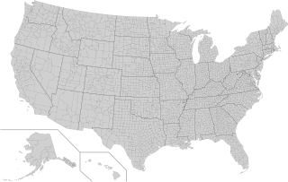
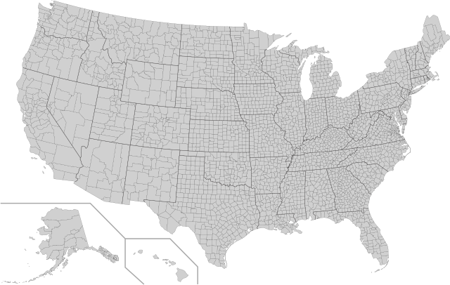
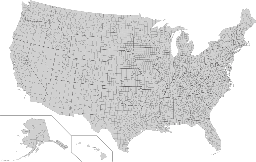
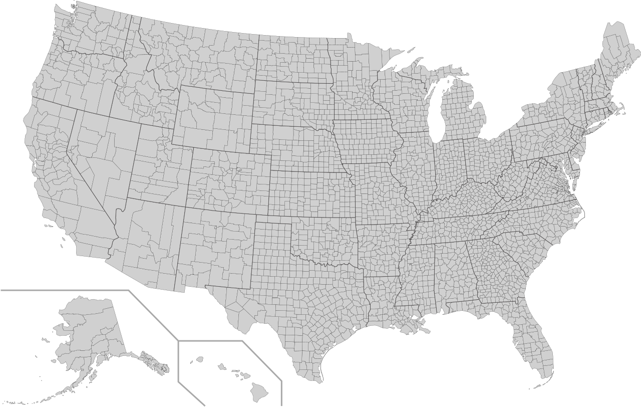
English: This is a map of the United States showing the borders of states and counties in high detail. |
|||
| Zdroj |
It was derived from this public-domain document published by the U.S. Census Bureau. |
|||
| Autor | U.S. Census Bureau | |||
| Svolení (Užití tohoto souboru) |
|
|||
| Další verze | Díla odvozená od tohoto souboru: Usa counties large.svg | |||
| SVG vývoj | Tento vektorový obrázek byl vytvořen programem Inkscape |

Historie souboru
Kliknutím na datum a čas se zobrazí tehdejší verze souboru.
| Datum a čas | Náhled | Rozměry | Uživatel | Komentář | |
|---|---|---|---|---|---|
| současná | 10. 8. 2022, 07:18 | | 555 × 352 (1,11 MB) | DemonDays64 | Fixed some problems: merged southern part of Unorganized Alaska into one shape; properly labeled Somerset MD, which Accomack VA had been mislabeled as |
| 17. 9. 2020, 08:22 |  | 555 × 352 (1,11 MB) | DemonDays64 | Fixed misspelling of "Albemarle" as "Albermarle" | |
| 10. 9. 2018, 17:56 |  | 555 × 352 (1,11 MB) | JoKalliauer | restored id-names and css from 03:49, 26. Mär. 2016 | |
| 30. 8. 2018, 08:38 |  | 555 × 352 (670 KB) | JoKalliauer | Smaller file-size. Cleaner code. valid file | |
| 26. 3. 2016, 05:49 |  | 555 × 352 (1,58 MB) | Spesh531 | updating borders, more accurate | |
| 23. 12. 2007, 17:47 |  | 555 × 352 (2,03 MB) | Lokal Profil | Fixed state borders and fixed the two parts of Fulton County (Kentucky) | |
| 10. 12. 2007, 04:20 |  | 555 × 352 (2,04 MB) | Lokal Profil | Graphical and code cleanup | |
| 10. 12. 2007, 03:15 |  | 792 × 612 (2,04 MB) | Lokal Profil | First stab at a code cleanup | |
| 29. 8. 2006, 02:14 |  | 792 × 612 (2,71 MB) | Petr Dlouhý | Original file: en:Image:USA CountiesSVG.zip This ZIP file contains an SVG map of the United States showing the borders of states and counties in high detail. It was derived from [http://www2.census.gov/geo/maps/special |
Využití souboru
Tento soubor nepoužívá žádná stránka.
Globální využití souboru
Tento soubor využívají následující wiki:
- Využití na af.wikipedia.org
- Využití na en.wikipedia.org
- Využití na fa.wikipedia.org
- Využití na fi.wikipedia.org
- Využití na he.wikipedia.org
- Využití na hi.wikipedia.org
- Využití na hu.wikipedia.org
- Využití na io.wikipedia.org
- Využití na pnb.wikipedia.org
- Využití na pt.wikipedia.org
- Využití na ro.wikipedia.org
- Využití na sh.wikipedia.org
- Využití na sq.wikipedia.org
- Využití na sr.wikipedia.org
- Využití na tr.wikipedia.org
- Využití na ur.wikipedia.org