
Soubor:TAP TANAP SCP Schah Denis.png

Velikost tohoto náhledu: 800 × 259 pixelů. Jiná rozlišení: 320 × 103 pixelů | 640 × 207 pixelů | 1 024 × 331 pixelů | 1 280 × 414 pixelů | 3 178 × 1 027 pixelů.
Původní soubor (3 178 × 1 027 pixelů, velikost souboru: 723 KB, MIME typ: image/png)
| Tento soubor pochází z Wikimedia Commons. Níže jsou zobrazeny informace, které obsahuje jeho tamější stránka s popisem souboru. |
Popis
| Popis |
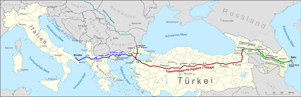
English: Map showing the location of the Shah Deniz gas field, the route of the South Caucasus Pipeline (SCP), the Trans-Anatolian gas pipeline (TANAP) under construction and the planned Trans Adriatic Pipeline (TAP), as well as the not realized Nabucco pipeline. Text in German
Deutsch: Lagekarte des Schah-Denis-Gasfeldes, der Trasse der Südkaukasus-Pipeline (SCP), der im Bau befindlichen Transanatolischen Pipeline (TANAP) und der geplanten Trans-Adria-Pipeline (TAP), sowie eines Teils der nicht realisierten Nabucco-Pipeline. |
| Datum | |
| Zdroj |
Vlastní dílo, map was created using ...
|
| Autor | |
| Svolení (Užití tohoto souboru) |
Map data (c) OpenStreetMap (and) contributors, CC-BY-SA |
Licence
Tento soubor podléhá licenci Creative Commons Uveďte autora-Zachovejte licenci 2.0 Generic
- Dílo smíte:
- šířit – kopírovat, distribuovat a sdělovat veřejnosti
- upravovat – pozměňovat, doplňovat, využívat celé nebo částečně v jiných dílech
- Za těchto podmínek:
- uveďte autora – Máte povinnost uvést autorství, poskytnout odkaz na licenci a uvést, pokud jste provedli změny. Toho můžete docílit jakýmkoli rozumným způsobem, avšak ne způsobem naznačujícím, že by poskytovatel licence schvaloval nebo podporoval vás nebo vaše užití díla.
- zachovejte licenci – Pokud tento materiál jakkoliv upravíte, přepracujete nebo použijete ve svém díle, musíte své příspěvky šířit pod stejnou nebo slučitelnou licencí jako originál.
Historie souboru
Kliknutím na datum a čas se zobrazí tehdejší verze souboru.
| Datum a čas | Náhled | Rozměry | Uživatel | Komentář | |
|---|---|---|---|---|---|
| současná | 27. 6. 2022, 10:14 | 3 178 × 1 027 (723 KB) | Ahmet Q. | Reverted to version as of 21:42, 10 January 2015 (UTC) | |
| 13. 6. 2018, 11:56 | 3 178 × 1 027 (293 KB) | Nicolay Sidorov | Abkhazia and South Ossetia are lowlighted like Nagorno-Karabakh in this map | ||
| 12. 5. 2018, 06:52 | 3 178 × 1 027 (306 KB) | Nicolay Sidorov | Neutrality. Kosovo is Serbia, because Crimea is Ukraine, Abkhazia and South Ossetia are Georgia and Karabakh is Azerbaijan in this map | ||
| 10. 1. 2015, 23:42 | 3 178 × 1 027 (723 KB) | Kopiersperre | optipng | ||
| 6. 1. 2015, 21:46 | 3 178 × 1 027 (1,09 MB) | Pechristener | nachgebessert gemäss Disk Kartenwerkstatt | ||
| 5. 1. 2015, 22:04 | 3 178 × 1 027 (1,11 MB) | Pechristener | nachgebessert: Lesbos eingefügt, Landesgrenzen repariert | ||
| 5. 1. 2015, 00:59 | 3 178 × 1 027 (1,1 MB) | Pechristener | Sardinien repariert | ||
| 3. 1. 2015, 20:32 | 3 178 × 1 027 (1,1 MB) | Pechristener | Einge Mängel gemäss Disk KW behoben. | ||
| 3. 1. 2015, 18:55 | 3 178 × 1 027 (1,11 MB) | Pechristener | {{Information |Description={{en|Map showing the location of the Shah Deniz gas field, the route of the South Caucasus Pipeline (SCP), the [[:en:Trans-Anatolian gas pipeline|Trans-Anatolian ga... |
Využití souboru
Tento soubor používají následující 3 stránky:
Globální využití souboru
Tento soubor využívají následující wiki:
- Využití na ar.wikipedia.org
- Využití na az.wikipedia.org
- Využití na bn.wikipedia.org
- Využití na de.wikipedia.org
- Využití na el.wikipedia.org
- Využití na en.wikipedia.org
- Využití na es.wikipedia.org
- Využití na fa.wikipedia.org
- Využití na fr.wikipedia.org
- Využití na it.wikipedia.org
- Využití na ja.wikipedia.org
- Využití na ka.wikipedia.org
- Využití na no.wikipedia.org
- Využití na ru.wikipedia.org
- Využití na sq.wikipedia.org
- Využití na tr.wikipedia.org
- Využití na tt.wikipedia.org
- Využití na uk.wikipedia.org
- Využití na www.wikidata.org
- Využití na zh.wikipedia.org