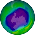
Soubor:NASA and NOAA Announce Ozone Hole is a Double Record Breaker.png

Velikost tohoto náhledu: 600 × 600 pixelů. Jiná rozlišení: 240 × 240 pixelů | 480 × 480 pixelů | 716 × 716 pixelů.
Původní soubor (716 × 716 pixelů, velikost souboru: 411 KB, MIME typ: image/png)
Historie souboru
Kliknutím na datum a čas se zobrazí tehdejší verze souboru.
| Datum a čas | Náhled | Rozměry | Uživatel | Komentář | |
|---|---|---|---|---|---|
| současná | 18. 2. 2012, 04:40 |  | 716 × 716 (411 KB) | Ras67 | JPEG artifacts mitigated and background removed |
| 28. 8. 2007, 22:29 |  | 716 × 716 (409 KB) | Nils Simon |
Využití souboru
Tento soubor používá následující stránka:
Globální využití souboru
Tento soubor využívají následující wiki:
- Využití na af.wikipedia.org
- Využití na als.wikipedia.org
- Využití na ar.wikipedia.org
- Využití na az.wikipedia.org
- Využití na be.wikipedia.org
- Využití na bg.wikipedia.org
- Využití na bn.wikipedia.org
- Využití na bs.wikipedia.org
- Využití na ca.wikipedia.org
- Využití na cv.wikipedia.org
- Využití na de.wikipedia.org
- Využití na de.wikibooks.org
- Využití na el.wikipedia.org
- Využití na en.wikipedia.org
- Využití na en.wikibooks.org
- Využití na en.wikinews.org
- Využití na es.wikipedia.org
Zobrazit další globální využití tohoto souboru.


