
Soubor:Mughals India 17th century-cs.png

Velikost tohoto náhledu: 407 × 599 pixelů. Jiná rozlišení: 163 × 240 pixelů | 326 × 480 pixelů | 522 × 768 pixelů | 1 116 × 1 642 pixelů.
Původní soubor (1 116 × 1 642 pixelů, velikost souboru: 576 KB, MIME typ: image/png)
| Tento soubor pochází z Wikimedia Commons. Níže jsou zobrazeny informace, které obsahuje jeho tamější stránka s popisem souboru. |
| Popis |
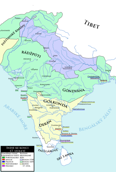
Čeština: Indie ke konci 17. století spolu se zobrazením expanze Mughalské říše a základním přhledem evropských kolonií v oblasti
English: India at the end of the 17th century with expansion of the Moghul Empire and basic overview of European colonies in the area. (Czech language) |
| Datum | (UTC) |
| Zdroj | |
| Autor |
|
| Další verze | العربيَّة |
| Toto je upravený obrázek, což znamená, že byl oproti původní verzi digitálně změněn. Úpravy: new map, combination of charts made by Joppe and another one to correct the extent of Moghul power. Původní verzi je možné zhlédnout zde: Mughal empire large.png. Úpravy provedl Mozzan.
|
| Já, autor tohoto díla, jej tímto uvolňuji jako volné dílo, a to celosvětově. V některých zemích to není podle zákona možné; v takovém případě: Poskytuji komukoli právo užívat toto dílo za libovolným účelem, a to bezpodmínečně s výjimkou podmínek vyžadovaných zákonem. |
Původní historie souboru
This image is a derivative work of the following images:
- File:India_in_1525_Joppen.jpg licensed with PD-US
- 2010-03-06T23:44:16Z Abecedare 1251x1824 (343051 Bytes) {{Information |Description={{en|1=Map of India in 1525}} |Source= "Historical Atlas of India," by Charles Joppen (London: Longmans, Green & Co., 1907) |Author=Charles Joppen |Date=1907 |Permission= |other_versions= }}
- File:India_in_1605.jpg licensed with PD-US
- 2010-03-06T23:47:37Z Abecedare 1248x1832 (333121 Bytes) == Summary == {{Information |Description={{en|1=Map of India in 1605}} |Source= "[http://www.columbia.edu/itc/mealac/pritchett/00maplinks/mughal/joppenset/joppenset.html Historical Atlas of India]," by Charles Joppen (London:
- File:India_in_1700_Joppen.jpg licensed with PD-US
- 2010-03-06T23:48:41Z Abecedare 1259x1820 (305244 Bytes) == Summary == {{Information |Description={{en|1=Map of India in 1700}} |Source= "[http://www.columbia.edu/itc/mealac/pritchett/00maplinks/mughal/joppenset/joppenset.html Historical Atlas of India]," by Charles Joppen (London:
- File:Mughal_empire_large.png licensed with Cc-pd-mark-footer, PD-USGov
- 2005-03-24T22:23:36Z Bontenbal 500x664 (94593 Bytes) {{PD-USGov}} [[category:Historical maps]][[category:Maps of India]] Source [[:en:Image:Mughal empire large.png]]
Uploaded with derivativeFX
Historie souboru
Kliknutím na datum a čas se zobrazí tehdejší verze souboru.
| Datum a čas | Náhled | Rozměry | Uživatel | Komentář | |
|---|---|---|---|---|---|
| současná | 12. 4. 2013, 11:33 | | 1 116 × 1 642 (576 KB) | Mozzan | Correction of factography |
| 8. 10. 2011, 13:35 |  | 1 100 × 1 560 (574 KB) | Podzemnik | little cropped on the top and right | |
| 7. 10. 2011, 23:06 |  | 1 116 × 1 642 (576 KB) | Mozzan | {{Information |Description={{cs|1=Indie ke konci 18. století spolu se zobrazením expanze Mughalské říše a základním přhledem evropských kolonií v oblasti}} {{en|1=India at the end of the 18th century with expansion of the Moghul Empire and basi |
Využití souboru
Tento soubor používá následující stránka: