
Soubor:IslamicConquestsIroon.png
Velikost tohoto náhledu: 675 × 599 pixelů. Jiná rozlišení: 270 × 240 pixelů | 541 × 480 pixelů | 1 006 × 893 pixelů.
Původní soubor (1 006 × 893 pixelů, velikost souboru: 105 KB, MIME typ: image/png)
| Tento soubor pochází z Wikimedia Commons. Níže jsou zobrazeny informace, které obsahuje jeho tamější stránka s popisem souboru. |

|
Tento obrázek (skupina historical map) by měl být vytvořen pomocí vektorové grafiky jako SVG soubor. To má několik výhod; podrobnosti najdete na stránce Commons:Media for cleanup. Je-li SVG verze tohoto obrázku již k dispozici, prosím nahrajte ji. Po nahrání nahraďte tuto šablonu šablonou {{Vector version available|jméno nového obrázku.svg}}.
|
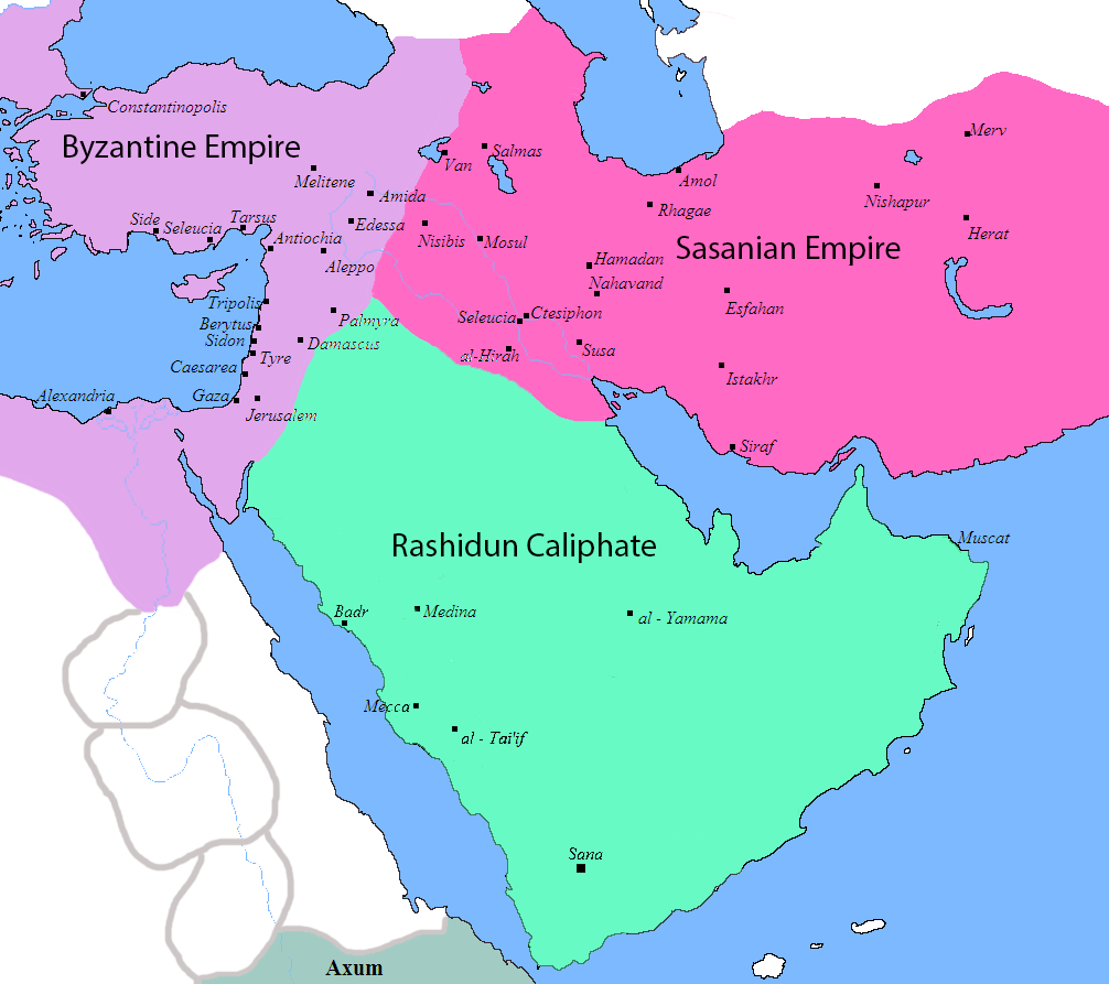
| Popis |
English: Map of the Sassanid, Byzantine and Muslim borders. |
| Zdroj | File:Pre_Islamic_Arabia.PNG |
| Autor | Javierfv1212 and edited by HistoryofIran. |
| Další verze |
[]
|


This file is in the public domain because File:Pre_Islamic_Arabia.PNG
|
Historie souboru
Kliknutím na datum a čas se zobrazí tehdejší verze souboru.
| Datum a čas | Náhled | Rozměry | Uživatel | Komentář | |
|---|---|---|---|---|---|
| současná | 18. 9. 2019, 12:13 | | 1 006 × 893 (105 KB) | HistoryofIran | rv, thats not how it works |
| 18. 9. 2019, 06:51 |  | 1 006 × 893 (103 KB) | Сахалин21 | Under Hormizd IV, Persia won the Perso-Turkic War and conquered Samarqand and the Transoxiania. | |
| 18. 9. 2019, 06:50 |  | 1 006 × 893 (105 KB) | Сахалин21 | Reverted to version as of 01:15, 3 August 2019 (UTC) | |
| 18. 9. 2019, 06:45 |  | 1 006 × 893 (103 KB) | Сахалин21 | Reverted to version as of 19:13, 14 November 2017 (UTC) | |
| 3. 8. 2019, 03:15 |  | 1 006 × 893 (105 KB) | HistoryofIran | rv, no, they weren't at all | |
| 1. 8. 2019, 20:38 |  | 1 006 × 893 (105 KB) | Mehrdad 12 | The eastern borders were conquered during the reign of Queen Purandokht. | |
| 1. 8. 2019, 20:34 |  | 1 006 × 893 (106 KB) | Mehrdad 12 | I corrected the eastern borders. The Great Khorasan and Khwarizmi Desert were considered imperial. | |
| 12. 2. 2019, 04:51 |  | 1 006 × 893 (105 KB) | HistoryofIran | Made the map somewhat more accurate, probably more to come. | |
| 14. 11. 2017, 21:13 |  | 1 006 × 893 (103 KB) | HistoryofIran | rv, the Sasanian Empire didnt control that much | |
| 12. 11. 2017, 13:02 |  | 1 006 × 893 (128 KB) | Mehrdad 12 | {{NAMESPACE}}{{PAGENAME}}[[]][[:File:]]]] |
Využití souboru
Tento soubor používá následující stránka:
Globální využití souboru
Tento soubor využívají následující wiki:
- Využití na bg.wikipedia.org
- Využití na bn.wikipedia.org
- Využití na bn.wikiquote.org
- Využití na bs.wikipedia.org
- Využití na da.wikipedia.org
- Využití na de.wikipedia.org
- Využití na diq.wikipedia.org
- Využití na en.wikipedia.org
- Využití na fa.wikipedia.org
- Využití na fa.wikibooks.org
- Využití na fi.wikipedia.org
- Využití na fr.wikipedia.org
- Využití na he.wikipedia.org
- Využití na hr.wikipedia.org
- Využití na hy.wikipedia.org
- Využití na hyw.wikipedia.org
- Využití na ka.wikipedia.org
- Využití na ko.wikipedia.org
- Využití na ru.wikipedia.org
- Využití na sr.wikipedia.org
- Využití na sv.wikipedia.org
- Využití na ta.wikipedia.org
- Využití na th.wikipedia.org
- Využití na tr.wikipedia.org
- Využití na uk.wikipedia.org
- Využití na uz.wikipedia.org
- Využití na zh.wikipedia.org