
Soubor:Viedma volcanic complex.jpg
Větší rozlišení není k dispozici
Viedma_volcanic_complex.jpg (640 × 422 pixelů, velikost souboru: 64 KB, MIME typ: image/jpeg)
| Tento soubor pochází z Wikimedia Commons. Níže jsou zobrazeny informace, které obsahuje jeho tamější stránka s popisem souboru. |
Popis
| Popis |
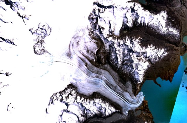
English: The figure-8-shaped area rising above the Patagonian Icefield at the upper left part of this NASA Landsat mosaic is part of the Viedma volcanic complex. An outflow glacier descends into Lake Viedma at the lower right. This mostly subglacial volcano produced an eruption in 1988 that confirmed the presence of a postulated subglacial vent in the Patagonian Icefield NW of Viedma Lake. The 1988 eruption deposited ash and pumice on the icecap and produced a mudflow that reached Viedma Lake. |
| Datum | neznámé datum |
| Zdroj | http://www.volcano.si.edu/world/volcano.cfm?vnum=1508-061&volpage=photos&photo=115011 |
| Autor | NASA Landsat7 image (worldwind.arc.nasa.gov) |
Licence
| This image is in the public domain because it is a screenshot from NASA’s globe software World Wind using a public domain layer, such as Blue Marble, MODIS, Landsat, SRTM, USGS or GLOBE.
|
 |
Historie souboru
Kliknutím na datum a čas se zobrazí tehdejší verze souboru.
| Datum a čas | Náhled | Rozměry | Uživatel | Komentář | |
|---|---|---|---|---|---|
| současná | 15. 10. 2010, 17:37 | | 640 × 422 (64 KB) | Michael Metzger | {{Information |Description={{en|1= The figure-8-shaped area rising above the Patagonian Icefield at the upper left part of this NASA Landsat mosaic is part of the Viedma volcanic complex. An outflow glacier descends into Lake Viedma at the lower right. Th |
Využití souboru
Tento soubor používá následující stránka:
Globální využití souboru
Tento soubor využívají následující wiki:
- Využití na arz.wikipedia.org
- Využití na de.wikipedia.org
- Využití na en.wikipedia.org
- Využití na es.wikipedia.org
- Využití na fr.wikipedia.org
- Využití na pt.wikipedia.org
- Využití na sk.wikipedia.org
- Využití na uk.wikipedia.org
- Využití na www.wikidata.org