
Soubor:ScotlandHighlands.png
Větší rozlišení není k dispozici
ScotlandHighlands.png (200 × 230 pixelů, velikost souboru: 4 KB, MIME typ: image/png)
| Tento soubor pochází z Wikimedia Commons. Níže jsou zobrazeny informace, které obsahuje jeho tamější stránka s popisem souboru. |
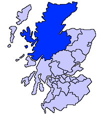
Popis
| Popis |
English: Highland unitary council |
| Zdroj | |
| Autor | Slightly edited version of a map drawn by Morwen |

|
K tomuto obrázku existuje vektorová verze (v SVG). Pokud je lepší, používejte raději tu.
File:ScotlandHighlands.png → File:ScotlandHighlandCouncil.svg
Podrobnější informace o vektorové grafice najdete na stránce Commons:Transition to SVG. Také si můžete přečíst informace o podpoře formátu SVG v MediaWiki. |
 |
Licence

|
Tento dokument smí být kopírován, šířen nebo upravován podle podmínek Svobodné licence GNU pro dokumenty verze 1.2 nebo libovolné vyšší verze publikované nadací Free Software Foundation. Dokument nemá neměnné části ani texty na předním či zadním přebalu. Kopie textu licence je k dispozici v oddíle nazvaném GNU Free Documentation License. |
| Tento soubor podléhá licenci Creative Commons Uveďte autora-Zachovejte licenci 3.0 Unported | ||
| ||
| Tato licenční šablona byla k tomuto souboru přidána v rámci změny licencování. |
Historie souboru
Kliknutím na datum a čas se zobrazí tehdejší verze souboru.
| Datum a čas | Náhled | Rozměry | Uživatel | Komentář | |
|---|---|---|---|---|---|
| současná | 17. 5. 2005, 23:36 | | 200 × 230 (4 KB) | Voyager | Highland unitary council Slightly edited version of a map drawn by Morwen {{GFDL}} Category:Maps of Scottish unitary councils |
Využití souboru
Tento soubor nepoužívá žádná stránka.
Globální využití souboru
Tento soubor využívají následující wiki:
- Využití na ast.wikipedia.org
- Využití na be.wikipedia.org
- Využití na bg.wikipedia.org
- Využití na br.wikipedia.org
- Využití na cy.wikipedia.org
- Využití na da.wikipedia.org
- Využití na en.wikipedia.org
- Caithness
- Skye and Lochalsh
- Highland Council wards and councillors 2003 to 2007
- Highland Council wards and councillors 1999 to 2003
- Highland Council wards created in 2007
- Highland Council wards 1999 to 2007
- Highland Council wards 1995 to 1999
- Category:Scotland articles missing geocoordinate data
- Category:Highland articles missing geocoordinate data
- Wikipedia:GLAM/SLIC/Library Partners
- Highland Council Wards in 2017
- Využití na eu.wikipedia.org
- Inverness
- Highland
- Eskoziako Lur Garaiak
- Fort William (Eskozia)
- Eilean Donan
- Lankide:Euskaldunaa
- Kyle of Lochalsh
- Ullapool
- Nairn
- Portree
- Broadford (Eskozia)
- John o' Groats
- Kingussie
- Aviemore
- Kyleakin
- Glenfinnan
- Dornoch
- Thurso (Eskozia)
- Txantiloi:Highland
- Alness
- Brora
- Dingwall
- Fortrose
- Grantown-on-Spey
- Invergordon
- Inverlochy (Highland)
- Mallaig
- Tain
- Wick (Caithness)
- Abernethy and Kincardine
- Achnahannet (Strathspey)
- Advie
- Alvie
Zobrazit další globální využití tohoto souboru.