
Soubor:ScotlandDumfriesGalloway.png
Větší rozlišení není k dispozici
ScotlandDumfriesGalloway.png (200 × 230 pixelů, velikost souboru: 4 KB, MIME typ: image/png)
| Tento soubor pochází z Wikimedia Commons. Níže jsou zobrazeny informace, které obsahuje jeho tamější stránka s popisem souboru. |
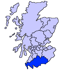
Dumfries and Galloway unitary council
Slightly edited version of a map drawn by Morwen

|
Tento dokument smí být kopírován, šířen nebo upravován podle podmínek Svobodné licence GNU pro dokumenty verze 1.2 nebo libovolné vyšší verze publikované nadací Free Software Foundation. Dokument nemá neměnné části ani texty na předním či zadním přebalu. Kopie textu licence je k dispozici v oddíle nazvaném GNU Free Documentation License. |
| Tento soubor podléhá licenci Creative Commons Uveďte autora-Zachovejte licenci 3.0 Unported | ||
| ||
| Tato licenční šablona byla k tomuto souboru přidána v rámci změny licencování. |
Historie souboru
Kliknutím na datum a čas se zobrazí tehdejší verze souboru.
| Datum a čas | Náhled | Rozměry | Uživatel | Komentář | |
|---|---|---|---|---|---|
| současná | 17. 5. 2005, 23:31 | | 200 × 230 (4 KB) | Voyager | Dumfries and Galloway unitary council Slightly edited version of a map drawn by Morwen {{GFDL}} Category:Maps of Scottish unitary councils |
Využití souboru
Tento soubor nepoužívá žádná stránka.
Globální využití souboru
Tento soubor využívají následující wiki:
- Využití na ast.wikipedia.org
- Využití na be.wikipedia.org
- Využití na bg.wikipedia.org
- Využití na ca.wikipedia.org
- Využití na cy.wikipedia.org
- Využití na de.wikipedia.org
- Využití na de.wikivoyage.org
- Využití na en.wikipedia.org
- Využití na eu.wikipedia.org
- Dumfries eta Galloway
- Dumfries
- Lankide:Euskaldunaa
- Stranraer
- Annan
- Txantiloi:Dumfries eta Galloway
- Wikiproiektu:Irlanda, Gales eta Eskoziako udalerriak
- Applegarthtown
- Inch (Dumfries eta Galloway)
- Bladnoch (Wigtownshire)
- Cairnryan
- Glasserton
- Glenluce
- Kirkcolm
- Kirkmaiden
- Leswalt
- Mochrum
- New Luce
- Newton Stewart
- Old Luce
- Penninghame
- Port William (Dumfries eta Galloway)
- Portpatrick
- Sandhead
- Sorbie
- Stoneykirk
- Wigtown
- Whithorn
- Kirkcowan
- Kirkinner
- Anwoth
- Caerlaverock
- Barburgh Mill
- Brow (Dumfries eta Galloway)
Zobrazit další globální využití tohoto souboru.