
Soubor:Post Roman Balkans.jpg
Původní soubor (2 038 × 1 677 pixelů, velikost souboru: 721 KB, MIME typ: image/jpeg)
| Tento soubor pochází z Wikimedia Commons. Níže jsou zobrazeny informace, které obsahuje jeho tamější stránka s popisem souboru. |
Bilindik köyü
Popis
| Popis |
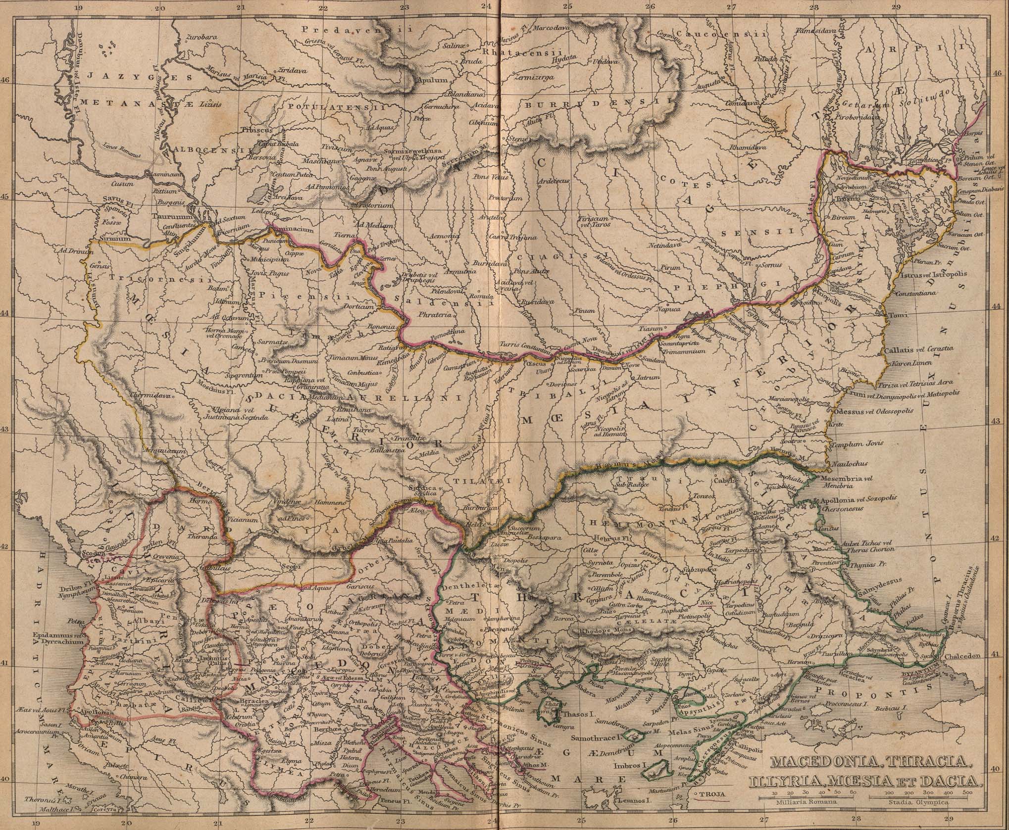
Macedonia, Thracia, Illyria, Moesia, Dacia,(Map X),"Comment on Map from author; Map X., & c. - Although most portions of this map are well represented, still we have a deficiency in the classical portion, as it has not been yet sufficiently examined by those who are capable of deciding and systematizing the comparative geography."
|
||||
| Datum | |||||
| Zdroj | A classical atlas, to illustrate ancient geography: comprised in twenty-five maps, showing the various divisions of the world as known to the ancients : composed from the most authentic sources with an index of the ancient and modern names,Alexander G. Findlay,Publisher;Harper,1849 | ||||
| Autor | Alexander G. Findlay | ||||
| Svolení (Užití tohoto souboru) |
|
||||
| Další verze |
   |
||||
Historie souboru
Kliknutím na datum a čas se zobrazí tehdejší verze souboru.
| Datum a čas | Náhled | Rozměry | Uživatel | Komentář | |
|---|---|---|---|---|---|
| současná | 28. 1. 2010, 20:49 | | 2 038 × 1 677 (721 KB) | PANONIAN | Reverted to version as of 01:28, 27 March 2005 - restored original version which has more historical value. please upload your whitened version as a new separate file, not over this one, thank you |
| 17. 5. 2009, 12:02 |  | 2 038 × 1 677 (1,1 MB) | Alex:D | whitened | |
| 27. 3. 2005, 03:28 |  | 2 038 × 1 677 (721 KB) | Karmosin~commonswiki | Classical Balkans: from ''Map from "rothers Publishers, New York, 1849A Classical Atlas to Illustrate Ancient Geography,'' Alexander G. Findlay, Harper and B ros. NY 1849 {{PD-art}} category:History of the Balkans |
Využití souboru
Tento soubor používají následující 2 stránky:
Globální využití souboru
Tento soubor využívají následující wiki:
- Využití na ar.wikipedia.org
- Využití na arz.wikipedia.org
- Využití na azb.wikipedia.org
- Využití na az.wikipedia.org
- Využití na ba.wikipedia.org
- Využití na be-tarask.wikipedia.org
- Využití na be.wikipedia.org
- Využití na bg.wikipedia.org
- Využití na ca.wikipedia.org
- Využití na en.wikipedia.org
- Využití na eo.wikipedia.org
- Využití na es.wikipedia.org
- Využití na gl.wikipedia.org
- Využití na he.wikipedia.org
- Využití na hr.wikipedia.org
- Využití na hy.wikipedia.org
- Využití na it.wikipedia.org
- Využití na ja.wikipedia.org
- Využití na mk.wikipedia.org
- Využití na nl.wikipedia.org
- Využití na pt.wikipedia.org
- Využití na ro.wikipedia.org
- Využití na ru.wikipedia.org
- Využití na sv.wikipedia.org
- Využití na tr.wikipedia.org
Zobrazit další globální využití tohoto souboru.