
Soubor:Pan Am Flight 103. Crashed Lockerbie, Scotland, 21 December 1988.jpg

Původní soubor (3 021 × 2 177 pixelů, velikost souboru: 1,26 MB, MIME typ: image/jpeg)
| Tento soubor pochází z Wikimedia Commons. Níže jsou zobrazeny informace, které obsahuje jeho tamější stránka s popisem souboru. |
Popis
| Popis |
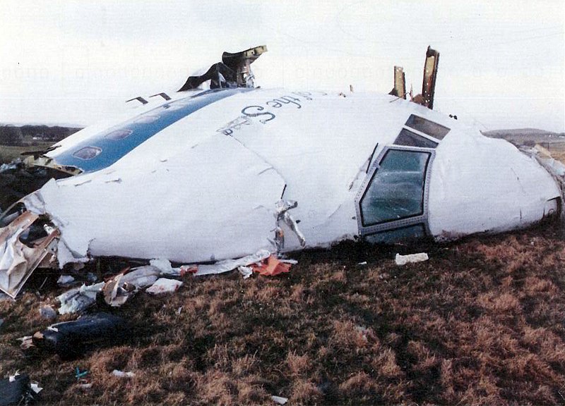
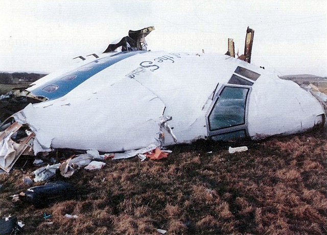
English: Pan Am Flight 103, 21 December 1988. Lockerbie bombing
Boeing 747–121, Clipper Maid of the Seas, Pan American World Airways, N739PA |
| Datum | |
| Zdroj |
Air Accident Investigation Branch Report No: 2/1990 - Report on the accident to Boeing 747-121, N739PA, at Lockerbie, Dumfriesshire, Scotland on 21 December 1988 Report name: 2/1990 Boeing 747-121, N739PA http://www.aaib.gov.uk/publications/formal_reports/2_1990_n739pa.cfm Appendix B, Image B-9 "Photograph of nose and flight deck" http://www.aaib.gov.uk/cms_resources.cfm?file=/2-1990%20N739PA%20Append.pdf |
| Autor | Air Accident Investigation Branch |
| Svolení (Užití tohoto souboru) |
"Extracts from AAIB reports may be published without specific permission providing that the source is duly acknowledged, the material is reproduced accurately and it is not used in a derogatory manner or in a misleading context." http://www.aaib.gov.uk/publications/ T&C "© Crown copyright, 2010 The material featured on this site is subject to Crown copyright protection unless otherwise indicated. The Crown copyright protected material (other than departmental or agency logos) may be reproduced free of charge in any format or medium, under the terms of the Open Government Licence. This is subject to the material being reproduced accurately and not used in a misleading context. Where any of the Crown copyright items on this site are being republished or copied to others, the source of the material must be identified and the copyright status acknowledged." http://www.aaib.gov.uk/_shared/_terms_conditions_4.html OGL http://www.nationalarchives.gov.uk/doc/open-government-licence/version/2/ |
| Pozice fotografa | | Tento snímek a mnohé další na: OpenStreetMap |
|---|
Licence
.svg)
|
This file is licensed under the United Kingdom Open Government Licence v2.0. |
See also: Meta for information on usage on Wikimedia wikis.
|
Historie souboru
Kliknutím na datum a čas se zobrazí tehdejší verze souboru.
| Datum a čas | Náhled | Rozměry | Uživatel | Komentář | |
|---|---|---|---|---|---|
| současná | 23. 12. 2021, 10:44 | | 3 021 × 2 177 (1,26 MB) | Sebastian Wallroth | cropped; colors adjusted |
| 28. 12. 2013, 18:10 |  | 3 025 × 2 185 (2,86 MB) | Thincat | User created page with UploadWizard |
Využití souboru
Tento soubor používá následující stránka:
Globální využití souboru
Tento soubor využívají následující wiki:
- Využití na af.wikipedia.org
- Využití na ar.wikipedia.org
- Využití na ar.wikinews.org
- Využití na ast.wikipedia.org
- Využití na az.wikipedia.org
- Využití na bg.wikipedia.org
- Využití na ca.wikipedia.org
- Využití na cy.wikipedia.org
- Využití na de.wikipedia.org
- Využití na el.wikipedia.org
- Využití na en.wikipedia.org
- List of accidents and incidents involving commercial aircraft
- Pan Am Flight 103 bombing investigation
- Pan Am Flight 103 conspiracy theories
- December 1988
- Pan Am Flight 103
- User:Itsfullofstars
- Wikipedia:WikiProject Aviation/Outreach
- Portal:Scotland/Selected articles
- Lockerbie
- Template:Infobox aircraft occurrence
- Template:Infobox aircraft occurrence/doc
- Wikipedia:WikiProject Aviation/Aviation accident task force/Participants
- Wikipedia:Userboxes/Aviation
- User:WilliamJE
- Template:Infobox aircraft occurrence/sandbox
- User:Hunterm267
- User:Steveb189/Gather lists/19000 – War
- Wikipedia:WikiProject Aviation/Outreach/User WPAVIATION Aviation accident task force
- User:Morag Kerr/sandbox
- User:Roberts.brannigan/sandbox
- User:Tigerdude9
- Portal:Scotland/Selected articles/41
- User:ZLEA/Wikiproject userboxes
- User:ZLEA/April Fools 2019/Userpage
- User:Cactus.man/Sandbox/P-Sco/Selected2
- User:Alpacaaviator
- User:Aviay
- User:MISSION 33/Userboxes
- User:Junesrose
- User:The0Quester/Events/1980s
- User:Dialupnetwork
- User:ZLEA
Zobrazit další globální využití tohoto souboru.