
Soubor:Oettingen Counties 1744.png

Velikost tohoto náhledu: 636 × 600 pixelů. Jiná rozlišení: 254 × 240 pixelů | 509 × 480 pixelů | 814 × 768 pixelů | 1 086 × 1 024 pixelů | 2 171 × 2 048 pixelů | 3 664 × 3 456 pixelů.
Původní soubor (3 664 × 3 456 pixelů, velikost souboru: 26,53 MB, MIME typ: image/png)
| Tento soubor pochází z Wikimedia Commons. Níže jsou zobrazeny informace, které obsahuje jeho tamější stránka s popisem souboru. |
Popis
| Popis |
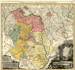
English: Map showing the territories of the House of Oettingen in the mid-18th century: the Principality of Oettingen (or Oettingen-Spielberg, in pink) and the Counties of Oettingen-Oettingen (light yellow), Oettingen-Baldern (aqua) and Oettingen-Wallerstein (yellow). Also shown (in purple) are the territories of the free imperial cities of Nördlingen (with its half-dozen exclaves), Bopfingen and Dinkelsbühl. The map, which contains information in Latin, French and German, was designed by M. F. Cnopf and published by Homann Erben (Homann Heirs) in 1744. |
| Datum | |
| Zdroj | Moll's map collection |
| Autor | M. F. Cnopf - Homann Heirs |
Licence
|
Toto dílo je volné také v zemích, jejichž právní řád chrání majetková autorská práva po dobu života autora a 100 let po jeho smrti. | |
| Bylo zjištěno, že u tohoto souboru nejsou známa žádná omezení daná autorským právem a právy s ním souvisejícími. | |
Historie souboru
Kliknutím na datum a čas se zobrazí tehdejší verze souboru.
| Datum a čas | Náhled | Rozměry | Uživatel | Komentář | |
|---|---|---|---|---|---|
| současná | 3. 7. 2018, 01:39 | | 3 664 × 3 456 (26,53 MB) | Lubiesque | User created page with UploadWizard |
Využití souboru
Tento soubor používá následující stránka:
Globální využití souboru
Tento soubor využívají následující wiki:
- Využití na de.wikipedia.org
- Využití na de.wikisource.org
- Využití na en.wikipedia.org
- Využití na he.wikipedia.org
- Využití na nl.wikipedia.org
- Využití na ru.wikipedia.org