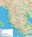
Soubor:Map of ancient Epirus and environs (English).svg

Obsah stránky není podporován v jiných jazycích.
Z Wikipedie, otevřené encyklopedie

Původní soubor(soubor SVG, nominální rozměr: 1 303 × 1 500 pixelů, velikost souboru: 495 KB)

Přeložit tento soubor Tento soubor ve formátu SVG obsahuje vložený text či texty, které lze přeložit do češtiny. K překladu je možné použít některé vektorové editory, textový editor nebo nástroj SVG Překladač. Pro více informací navštivte Nápovědu k překladům souborů SVG.

Popis

Popis
English: Map of ancient Epirus & Environs, Thracian, Illyrian, Paeonian, & Greek contact zones with illustration and extent of Hellenization up to the creation of Epirus Nova or Illyria Graeca
Datum
Zdroj Vlastní dílo
Autor MaryroseB54
Další verze

[editovat]

  • The classical age of Greece (1999),
  • ed. Atlas of the Greek and Roman world in antiquity (1981).
  • Hammond, N. G. L. A History of Greece to 322 B.C., 1986, ISBN-10: 0198730950
  • Wilkes, J. J. The Illyrians, 1992,ISBN 0631198075, (i.e. pages 174, 208, 210, 273)
  • In the Shadow of Olympus: The Emergence of Macedon,ISBN 0691008809,1992
  • Thracian Tribal areas (from Fol, Thrace and the Thracians, p 133),The Thracians 700 BC–AD 46 (Men-at-Arms 360) by Christopher Webber After Hoddinot, Col & Cah
  • Hendry, p. 299. The geography is entirely correct for Servius' time, since Diocletian's rearrangement of provincial boundaries included the creation of the province of Epirus Nova out of southern Illyricum with Dyrrachium (=Epidamnus) as its capital.
  • The Loeb Editor's Notes, 28 Nova Epirus or Illyris Graeca (Epirus, Nova Illyria Graeca) "Nova Epirus or Illyris Graeca extended from the Drilo (Mod. Drina) River on the north to the Ceraunian Mts. on the south, thus comprising a large part of modern Albania. Immediately to the south of it to the Ambracian Gulf (Mod. Gulf of Arta) lay what is here called Old Epirus, approximately identical with the Epirus of modern Greece."
  • Soustal, Peter; Koder, Johannes (1981). Tabula Imperii Byzantini, Band 3: Nikopolis und Kephallenia (in German). Vienna: Verlag der Osterreichischen Akademie der Wissenschaften. ISBN 3-7001-0399-9., page 47
  • A new classical dictionary of Greek and Roman biography, mythology, and geography: partly based upon the Dictionary of Greek and Roman biography and mythology by Sir William Smith,1851,page 392 "B. Illyris Graeca, which was called in later times Epirus Nova, extended from the river Drilo to the SE., up to the Ceraunian mountains, which separated it from Epirus Proper"
  • American journal of philology, Τόμοι 98-99,by JSTOR (Organization), Project Muse,1977,page 263, the partly Hellenic and partly Hellenized Epirus Nova
  • Epirus Vetus: The Archaeology of a Late Antique Province (Duckworth Archaeology) by William Bowden,2003,ISBN-10: 0715631160,2003,page 233,of Lissos in Epirus Nova
  • Migrations and invasions in Greece and adjacent areas by Nicholas Geoffrey Lempriere Hammond,1976,ISBN -0815550472,page 54,The line of division between Illyricum and the Greek area Epirus nova
  • Athanassakis, A.N. (1977), "N.G.L. Hammond, Migrations and Invasions in Greece and Adjacent Areas (review)", American Journal of Philology 99: 263–6, JSTOR 293653
  • Hammond, N. G. L. A History of Greece to 322 B.C., 1986, ISBN-10: 0198730950
  • Triadafilopoulos, Triadafilos (November 2000). "Power politics and nationalist discourse in the struggle for 'Northern Epirus': 1919-1921". Journal of Southern Europe and the Balkans,
  • Encyclopedia Britannica,2002,ISBN -0852297874,The Roman province of Illyricum stretched from the Drilon River (the Drin, in modern Albania) in the south to Istria (modem Slovenia and Croatia)
  • History of the Byzantine Empire: Vol. 1, 324-1453 (Paperback) by Alexander A. Vasiliev
  • Epire, Illyrie, Macedoine: melanges offerts au professeur Pierre Cabanes by Daniele Berranger,Pierre Cabanes,Daniele Berranger-Auserve,page 130
  • In An Inventory of Archaic and Classical Poleis by Mogens Herman, ISBN 0-19-814099-1, 2004, i.e. "As a long-distance trading community, Aigina was not an active coloniser, but colonised Kydonia (no. 968) in 519, Adria (no. 75) c.C61, and Damastion in Illyria after 431 (Strabo 8.6.16)." & page 348
  • The Cambridge Ancient History: The Hellenistic monarchies and the rise of Rome, 1964. page 836 "of mixed barbarian and Greek population, such as Dimale (or Dimallum), of unknown"
  • The Illyrian Atintani, the Epirotic Atintanes and the Roman Protectorate N. G. L. Hammond, The Journal of Roman Studies Vol. 79 (1989), pp. 11-25 "There were Illyrian Amantini in Pannonia and Greek Amantes in North Epirus"
  • Blank map from Image:Map greek sanctuaries-fr.svg (The empty map used is not topographic, nor does it offer the capacity of gps precision, but its easy on the eyes and aesthetically pleasing in general)

Licence

Já, držitel autorských práv k tomuto dílu, ho tímto zveřejňuji za podmínek následující licence:
w:cs:Creative Commons
uveďte autora zachovejte licenci
Dílo smíte:
  • šířit – kopírovat, distribuovat a sdělovat veřejnosti
  • upravovat – pozměňovat, doplňovat, využívat celé nebo částečně v jiných dílech
Za těchto podmínek:
  • uveďte autora – Máte povinnost uvést autorství, poskytnout odkaz na licenci a uvést, pokud jste provedli změny. Toho můžete docílit jakýmkoli rozumným způsobem, avšak ne způsobem naznačujícím, že by poskytovatel licence schvaloval nebo podporoval vás nebo vaše užití díla.
  • zachovejte licenci – Pokud tento materiál jakkoliv upravíte, přepracujete nebo použijete ve svém díle, musíte své příspěvky šířit pod stejnou nebo slučitelnou licencí jako originál.
Poznámky
InfoField
K tomuto souboru existují poznámky: Prohlédnout si poznámky na Commons

Popisky

Přidejte jednořádkové vysvětlení, co tento soubor představuje

Položky vyobrazené v tomto souboru

zobrazuje

Historie souboru

Kliknutím na datum a čas se zobrazí tehdejší verze souboru.

Datum a časNáhledRozměryUživatelKomentář
současná22. 11. 2021, 06:38Náhled verze z 22. 11. 2021, 06:381 303 × 1 500 (495 KB)KhirurgMeant to upload this version
22. 11. 2021, 06:22Náhled verze z 22. 11. 2021, 06:221 303 × 1 500 (495 KB)KhirurgMade some corrections
28. 12. 2020, 03:36Náhled verze z 28. 12. 2020, 03:361 303 × 1 500 (493 KB)CastellFile uploaded using svgtranslate tool (https://svgtranslate.toolforge.org/). Added translation for ca.
28. 12. 2020, 03:26Náhled verze z 28. 12. 2020, 03:261 303 × 1 500 (492 KB)CastellFile uploaded using svgtranslate tool (https://svgtranslate.toolforge.org/). Added translation for ca.
24. 6. 2016, 13:15Náhled verze z 24. 6. 2016, 13:151 303 × 1 500 (383 KB)MaryroseB54Parthos
23. 6. 2016, 01:58Náhled verze z 23. 6. 2016, 01:581 303 × 1 500 (382 KB)MaryroseB54as per source
23. 6. 2016, 00:52Náhled verze z 23. 6. 2016, 00:521 303 × 1 500 (382 KB)MaryroseB54Position
22. 6. 2016, 23:07Náhled verze z 22. 6. 2016, 23:071 303 × 1 500 (382 KB)MaryroseB54Position fix
20. 6. 2016, 12:06Náhled verze z 20. 6. 2016, 12:061 303 × 1 500 (382 KB)MaryroseB54User created page with UploadWizard

Tento soubor používá následující stránka:

Globální využití souboru

Metadata