
Soubor:Map en county of Toulouse 1154.jpg
Map_en_county_of_Toulouse_1154.jpg (394 × 293 pixelů, velikost souboru: 74 KB, MIME typ: image/jpeg)
| Tento soubor pochází z Wikimedia Commons. Níže jsou zobrazeny informace, které obsahuje jeho tamější stránka s popisem souboru. |
Popis
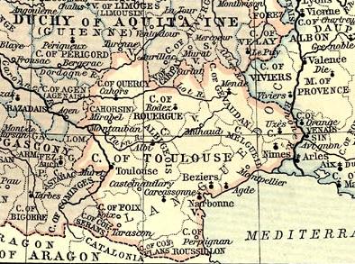
| Popis |
English: Map of County of Toulouse in 1154.
Français : Carte du comté de Toulouse en 1154. |
||||||||||||||||||||||
| Zdroj |
|
||||||||||||||||||||||
| Autor |
|
||||||||||||||||||||||
Licence
|
Toto dílo je volné také v zemích, jejichž právní řád chrání majetková autorská práva po dobu života autora a 70 let po jeho smrti.
| |
| Bylo zjištěno, že u tohoto souboru nejsou známa žádná omezení daná autorským právem a právy s ním souvisejícími. | |
Historie souboru
Kliknutím na datum a čas se zobrazí tehdejší verze souboru.
| Datum a čas | Náhled | Rozměry | Uživatel | Komentář | |
|---|---|---|---|---|---|
| současná | 26. 11. 2008, 20:32 | | 394 × 293 (74 KB) | Odejea | {{Information |Description={{en|1=Map of County of Toulouse in 1154.}} {{fr|1=Carte du comté de Toulouse en 1154.}} |Source=Atlas historique de William R. Shepherd |Author=William R. Shepherd |Date= | |
Využití souboru
Tento soubor používá následující stránka:
Globální využití souboru
Tento soubor využívají následující wiki:
- Využití na be.wikipedia.org
- Využití na br.wikipedia.org
- Využití na el.wikipedia.org
- Využití na en.wikipedia.org
- Využití na eo.wikipedia.org
- Využití na et.wikipedia.org
- Využití na eu.wikipedia.org
- Využití na it.wikipedia.org
- Využití na oc.wikipedia.org
- Využití na ru.wikipedia.org