
Soubor:Madhhab Map2.png
Velikost tohoto náhledu: 800 × 388 pixelů. Jiná rozlišení: 320 × 155 pixelů | 640 × 310 pixelů | 1 245 × 604 pixelů.
Původní soubor (1 245 × 604 pixelů, velikost souboru: 50 KB, MIME typ: image/png)
| Tento soubor pochází z Wikimedia Commons. Níže jsou zobrazeny informace, které obsahuje jeho tamější stránka s popisem souboru. |

|
Tento obrázek (skupina religion map) by měl být vytvořen pomocí vektorové grafiky jako SVG soubor. To má několik výhod; podrobnosti najdete na stránce Commons:Media for cleanup. Je-li SVG verze tohoto obrázku již k dispozici, prosím nahrajte ji. Po nahrání nahraďte tuto šablonu šablonou {{Vector version available|jméno nového obrázku.svg}}.
|
Popis
| Popis |
العربية: المدارس الفقهية الإسلامية الرئيسيّة وانتشارها حول العالم (لغة إنجليزية)
فارسی: نقشهٔ پراکندگی مذاهب فقهی اسلام در جهان (انگلیسی)
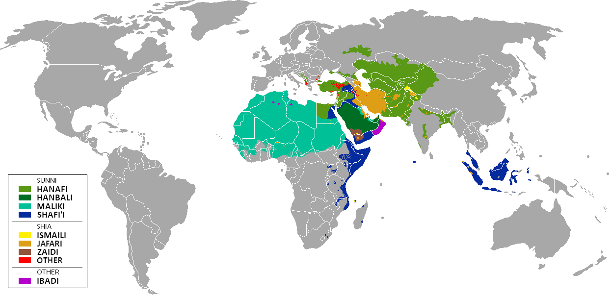
English: The distribution of the predominant Islamic madhhab (school of law) followed in majority-Muslim countries and regions (English)
Bahasa Indonesia: Distribusi penyebaran agama islam berdasarkan Mahdab di negara-negara dan wilayah dunia |
| Datum | |
| Zdroj | Own work by uploader from a blank-map, based on this source: Legal Sources and various other sources |
| Autor | Ghibar |
| Další verze |
Díla odvozená od tohoto souboru: |
Licence
Já, držitel autorských práv k tomuto dílu, ho tímto zveřejňuji za podmínek následujících licencí:
Tento soubor podléhá licenci Creative Commons Uveďte autora-Zachovejte licenci 3.0 Unported
- Dílo smíte:
- šířit – kopírovat, distribuovat a sdělovat veřejnosti
- upravovat – pozměňovat, doplňovat, využívat celé nebo částečně v jiných dílech
- Za těchto podmínek:
- uveďte autora – Máte povinnost uvést autorství, poskytnout odkaz na licenci a uvést, pokud jste provedli změny. Toho můžete docílit jakýmkoli rozumným způsobem, avšak ne způsobem naznačujícím, že by poskytovatel licence schvaloval nebo podporoval vás nebo vaše užití díla.
- zachovejte licenci – Pokud tento materiál jakkoliv upravíte, přepracujete nebo použijete ve svém díle, musíte své příspěvky šířit pod stejnou nebo slučitelnou licencí jako originál.

|
Tento dokument smí být kopírován, šířen nebo upravován podle podmínek Svobodné licence GNU pro dokumenty verze 1.2 nebo libovolné vyšší verze publikované nadací Free Software Foundation. Dokument nemá neměnné části ani texty na předním či zadním přebalu. Kopie textu licence je k dispozici v oddíle nazvaném GNU Free Documentation License. |
Můžete si zvolit libovolnou z těchto licencí.
| Poznámky | K tomuto souboru existují poznámky: Prohlédnout si poznámky na Commons |
Historie souboru
Kliknutím na datum a čas se zobrazí tehdejší verze souboru.
| Datum a čas | Náhled | Rozměry | Uživatel | Komentář | |
|---|---|---|---|---|---|
| současná | 23. 1. 2018, 13:24 | | 1 245 × 604 (50 KB) | Maphobbyist | Revert. Jafari school more widespread in northern Sumatra according to sources, than mere dots. |
| 30. 5. 2016, 13:55 |  | 1 245 × 604 (2,87 MB) | Riyantojayadi | Madhhab majority of Aceh region[1] and West Sumatra/Minangkabau region[2] in Indonesia are Syafii school of Sunni. There are some tribe's ritual in this area that are based on Shia such tabot, however, for religion, they are practicing . Shia communiti... | |
| 11. 1. 2015, 15:45 |  | 1 245 × 604 (50 KB) | AnonMoos | Reverted to version as of 02:11, 30 July 2014 -- see User_talk:Peaceworld111 | |
| 11. 1. 2015, 12:24 |  | 1 245 × 604 (52 KB) | Peaceworld111 | Re-added Ahmadi. It's a sect of Islam per reliable sources and is not a mere dot. See talk page. | |
| 11. 1. 2015, 04:10 |  | 1 245 × 604 (50 KB) | AnonMoos | Reverted to version as of 02:11, 30 July 2014 -- change not discussed on image talk page, possibly problematic, see user talk page | |
| 8. 1. 2015, 20:11 |  | 1 245 × 604 (52 KB) | Peaceworld111 | Added Ahmadi | |
| 30. 7. 2014, 04:11 |  | 1 245 × 604 (50 KB) | KronosLine | Fixed Russia | |
| 20. 7. 2014, 20:36 |  | 1 245 × 604 (63 KB) | Calthinus | distribution of Bektashis in Albania fixed, distribution of Muslims in Greece & Macedonia (esp the ethnic Slav Macedonian Muslims, whose distribution had previously not been marked) fixed, various other fixes... | |
| 19. 10. 2013, 19:50 |  | 1 245 × 604 (50 KB) | Hibernian | Damn it, that revert button doesn't do what I thought it does. Here's what I meant to change it to. This version also changes the Kerala Muslims to Shafi'i as was suggested on the talk page. | |
| 19. 10. 2013, 19:37 |  | 1 245 × 604 (55 KB) | Hibernian | Reverted to previous version. It is totally illogical to not show the borders of states with limited recognition (practically every map on Wikipedia depicts these entities), it has nothing to do with the official UN definitions, but with showing reality. |
Využití souboru
Tento soubor nepoužívá žádná stránka.
Globální využití souboru
Tento soubor využívají následující wiki:
- Využití na bn.wikipedia.org
- Využití na bn.wikivoyage.org
- Využití na en.wikipedia.org
- Využití na en.wikivoyage.org
- Využití na he.wikipedia.org
- Využití na hi.wikivoyage.org
- Využití na id.wikipedia.org
- Využití na incubator.wikimedia.org
- Využití na it.wikivoyage.org
- Využití na ja.wikipedia.org
- Využití na mzn.wikipedia.org
- Využití na uk.wikipedia.org