
Soubor:Liberal Arts College Dubăsari, Transnistria (14804623417).jpg

Původní soubor (4 510 × 3 382 pixelů, velikost souboru: 14 MB, MIME typ: image/jpeg)
| Tento soubor pochází z Wikimedia Commons. Níže jsou zobrazeny informace, které obsahuje jeho tamější stránka s popisem souboru. |
.jpg)
Popis
| Popis |
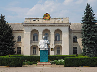
Dubăsari and its suburbs were the site of major conflict during 1990-1992, that eventually degenerated into the War of Transnistria (1992). Since then, it has been controlled by the breakaway administration of Transnistria. Transnistria (also called Trans-Dniestr or Transdniestria) is a breakaway state located mostly on a strip of land between the River Dniester and the eastern Moldovan border with Ukraine. Since its declaration of independence in 1990, and especially after the War of Transnistria in 1992, it is governed as the Pridnestrovian Moldavian Republic (PMR, also known as Pridnestrovie) a state with limited recognition that claims territory to the east of the River Dniester, and also to the city of Bender and its surrounding localities located on the west bank, in the historical region of Bessarabia. The terms "Transnistria" and "Pridnestrovie" both reference the Dniester River. Pridnestrovie retains a strong pride in it's Russian and Soviet heritages. |
| Datum | |
| Zdroj | Liberal Arts College Dubăsari, Transnistria |
| Autor | Clay Gilliland |
| Pozice fotografa | | Tento snímek a mnohé další na: OpenStreetMap |
|---|
.jpg¶ms=047.274886_N_0029.146480_E_globe:Earth_type:camera_source:Flickr_&language=cs)
Licence
- Dílo smíte:
- šířit – kopírovat, distribuovat a sdělovat veřejnosti
- upravovat – pozměňovat, doplňovat, využívat celé nebo částečně v jiných dílech
- Za těchto podmínek:
- uveďte autora – Máte povinnost uvést autorství, poskytnout odkaz na licenci a uvést, pokud jste provedli změny. Toho můžete docílit jakýmkoli rozumným způsobem, avšak ne způsobem naznačujícím, že by poskytovatel licence schvaloval nebo podporoval vás nebo vaše užití díla.
- zachovejte licenci – Pokud tento materiál jakkoliv upravíte, přepracujete nebo použijete ve svém díle, musíte své příspěvky šířit pod stejnou nebo slučitelnou licencí jako originál.
| This image was originally posted to Flickr by Clay Gilliland at https://www.flickr.com/photos/26781577@N07/14804623417. It was reviewed on 29. dubna 2015 by FlickreviewR and was confirmed to be licensed under the terms of the cc-by-sa-2.0. |
Historie souboru
Kliknutím na datum a čas se zobrazí tehdejší verze souboru.
| Datum a čas | Náhled | Rozměry | Uživatel | Komentář | |
|---|---|---|---|---|---|
| současná | 29. 4. 2015, 13:55 | | 4 510 × 3 382 (14 MB) | Butko | Transferred from Flickr via Flickr2Commons |
Využití souboru
Tento soubor používá následující stránka:
Globální využití souboru
Tento soubor využívají následující wiki:
- Využití na en.wikipedia.org
- Využití na es.wikipedia.org
- Využití na et.wikipedia.org
- Využití na fr.wikipedia.org
- Využití na id.wikipedia.org
- Využití na ja.wikipedia.org
- Využití na nl.wikipedia.org
- Využití na pl.wikipedia.org
- Využití na ro.wikipedia.org
- Využití na sr.wikipedia.org
.jpg)