
Soubor:Languages of CE Europe-3.PNG
Velikost tohoto náhledu: 524 × 599 pixelů. Jiná rozlišení: 210 × 240 pixelů | 419 × 480 pixelů | 951 × 1 088 pixelů.
Původní soubor (951 × 1 088 pixelů, velikost souboru: 769 KB, MIME typ: image/png)
| Tento soubor pochází z Wikimedia Commons. Níže jsou zobrazeny informace, které obsahuje jeho tamější stránka s popisem souboru. |
Popis
| Popis |
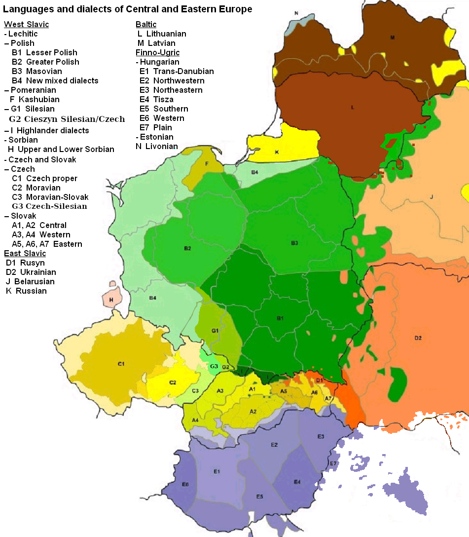
English: Map of languages and dialects of Central and Eastern Europe
Polski: Języki i dialekty Europy Srodkowo-Wschodniej
Deutsch: Legende:
|
||
| Datum | |||
| Zdroj |
Vlastní dílo |
||
| Autor | |||
| Další verze |
|

|
Tento obrázek (skupina linguistic map) by měl být vytvořen pomocí vektorové grafiky jako SVG soubor. To má několik výhod; podrobnosti najdete na stránce Commons:Media for cleanup. Je-li SVG verze tohoto obrázku již k dispozici, prosím nahrajte ji. Po nahrání nahraďte tuto šablonu šablonou {{Vector version available|jméno nového obrázku.svg}}.
|
Licence

|
Tento dokument smí být kopírován, šířen nebo upravován podle podmínek Svobodné licence GNU pro dokumenty verze 1.2 nebo libovolné vyšší verze publikované nadací Free Software Foundation. Dokument nemá neměnné části ani texty na předním či zadním přebalu. Kopie textu licence je k dispozici v oddíle nazvaném GNU Free Documentation License. |
| Tento soubor podléhá licenci Creative Commons Uveďte autora-Zachovejte licenci 3.0 Unported | ||
| Uveďte autora: Zaragoza, Kpalion, Dellijks | ||
| ||
| Tato licenční šablona byla k tomuto souboru přidána v rámci změny licencování. |
Původní historie souboru
This image is a derivative work of the following images:
- File:Languages_of_CE_Europe.PNG licensed with GFDL
- 2008-08-25T20:42:18Z Kpalion 951x1088 (1053557 Bytes) {{Information |Description={{en|Map of languages and dialects of Central and Eastern Europe}} |Source=*[[:Image:Jezyki_i_dialekty_Europa_Srodkowo_Wsch..jpg|]] |Date=2008-08-25 20:40 (UTC) |Author=*derivative work: ~~~ *[[:Ima
Historie souboru
Kliknutím na datum a čas se zobrazí tehdejší verze souboru.
| Datum a čas | Náhled | Rozměry | Uživatel | Komentář | |
|---|---|---|---|---|---|
| současná | 17. 8. 2019, 08:47 | | 951 × 1 088 (769 KB) | D T G | G1 - changed western border (compare my other map: File:Gwary śląskie wg Zaręby.png - sources there); G2 - changed name and classification (this was part of the Polish Cieszyn Silesian, after 1920 evolving towards Czech, but it was absurd that it would be classified as Czech when to South-West was just G1, not differentiated from G1 in Poland! I repeat it was absurd!, therefore I created G3, see below); G3 - created Czech-Silesian also know as Lach dialects, up to 1980s regarded by some... |
| 17. 8. 2015, 09:42 |  | 951 × 1 088 (928 KB) | Winnetou14 | Reverted to version as of 19:28, 13 September 2009 | |
| 12. 11. 2009, 01:11 |  | 951 × 1 088 (697 KB) | Alex Tora | {{Information |Description= |Source={{own}} |Date= |Author=Alex Tora |Permission= |other_versions= }} | |
| 13. 9. 2009, 21:28 |  | 951 × 1 088 (928 KB) | Scooter20 | Fixed Hungarian & Ukrainian in Romania, Ukrainian in Moldova and Romanian in Hungary and Ukraine | |
| 20. 7. 2009, 00:16 |  | 951 × 1 088 (982 KB) | Dellijks | {{Information |Description={{en|Map of languages and dialects of Central and Eastern Europe}}{{pl|Języki i dialekty Europy Srodkowo-Wschodniej}} {{de|-> * B1 - Kleinpolnisch * B2 - Großpolnisch * B3 - Masowisch * B4 - Hochpolnisch * F - Kaschubisch * G1 |
Využití souboru
Tento soubor používá následující stránka:
Globální využití souboru
Tento soubor využívají následující wiki:
- Využití na af.wikipedia.org
- Využití na als.wikipedia.org
- Využití na am.wikipedia.org
- Využití na ang.wikipedia.org
- Využití na an.wikipedia.org
- Využití na arz.wikipedia.org
- Využití na ast.wikipedia.org
- Využití na bo.wikipedia.org
- Využití na br.wikipedia.org
- Využití na csb.wikipedia.org
- Využití na cv.wikipedia.org
- Využití na da.wikipedia.org
- Využití na de.wikipedia.org
- Využití na diq.wikipedia.org
- Využití na el.wikipedia.org
- Využití na en.wikipedia.org
- Využití na en.wiktionary.org
- Využití na eo.wikipedia.org
- Využití na eu.wikipedia.org
- Využití na frr.wikipedia.org
- Využití na fr.wikipedia.org
- Využití na fur.wikipedia.org
- Využití na fy.wikipedia.org
- Využití na gd.wikipedia.org
- Využití na he.wikipedia.org
- Využití na hr.wikipedia.org
- Využití na hsb.wikipedia.org
- Využití na hy.wikipedia.org
- Využití na incubator.wikimedia.org
- Využití na ka.wikipedia.org
- Využití na ko.wikipedia.org
- Využití na la.wikipedia.org
- Využití na mg.wikipedia.org
- Využití na ms.wikipedia.org
- Využití na nl.wikipedia.org
- Využití na pnb.wikipedia.org
Zobrazit další globální využití tohoto souboru.