
Soubor:Klimate-humidität.png
Velikost tohoto náhledu: 800 × 400 pixelů. Jiná rozlišení: 320 × 160 pixelů | 640 × 320 pixelů | 1 024 × 512 pixelů | 1 280 × 640 pixelů | 3 600 × 1 800 pixelů.
Původní soubor (3 600 × 1 800 pixelů, velikost souboru: 2,84 MB, MIME typ: image/png)
| Tento soubor pochází z Wikimedia Commons. Níže jsou zobrazeny informace, které obsahuje jeho tamější stránka s popisem souboru. |
Popis
| Popis |
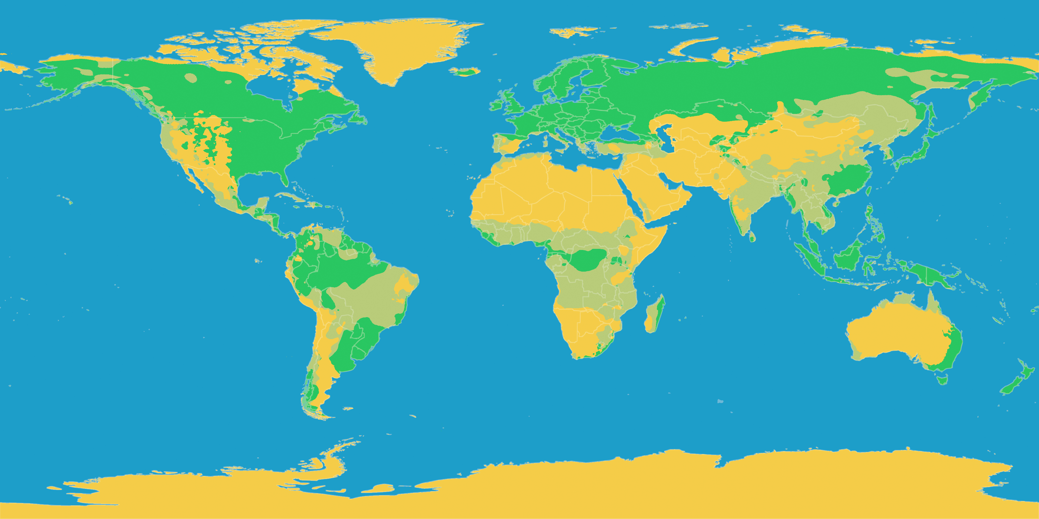
English: A map of Earth showing precipitation levels in different climates
Deutsch: Diese Karte stellt die Klimate der Erde nach ihrer Humidität dar.
Humides Klima
Teilarides Klima
Arides Klima |
| Datum | |
| Zdroj |
English: Own work based on the following paper. Deutsch: Selbst erstellt auf Basis dieser Geodaten:
|
| Autor | LordToran |
| Svolení (Užití tohoto souboru) |
|
| Další verze |
 |
Licence
Tento soubor podléhá licenci Creative Commons Uveďte autora-Zachovejte licenci 3.0 Unported
- Dílo smíte:
- šířit – kopírovat, distribuovat a sdělovat veřejnosti
- upravovat – pozměňovat, doplňovat, využívat celé nebo částečně v jiných dílech
- Za těchto podmínek:
- uveďte autora – Máte povinnost uvést autorství, poskytnout odkaz na licenci a uvést, pokud jste provedli změny. Toho můžete docílit jakýmkoli rozumným způsobem, avšak ne způsobem naznačujícím, že by poskytovatel licence schvaloval nebo podporoval vás nebo vaše užití díla.
- zachovejte licenci – Pokud tento materiál jakkoliv upravíte, přepracujete nebo použijete ve svém díle, musíte své příspěvky šířit pod stejnou nebo slučitelnou licencí jako originál.
Historie souboru
Kliknutím na datum a čas se zobrazí tehdejší verze souboru.
| Datum a čas | Náhled | Rozměry | Uživatel | Komentář | |
|---|---|---|---|---|---|
| současná | 14. 7. 2020, 16:26 | | 3 600 × 1 800 (2,84 MB) | Fährtenleser | Bessere Erkennbarkeit der Farbstufen für Farbsehschwache |
| 11. 10. 2016, 23:00 |  | 3 600 × 1 800 (828 KB) | Maphobbyist | The Kara Bogaz Lake was omitted. The Köppen system is based on the concept that climate types are correlated with the natural vegetation. | |
| 22. 6. 2010, 12:26 |  | 3 600 × 1 800 (659 KB) | Maphobbyist | Ther Caspian sea was total omitted. The Alps and central Norway are humid and not arid. The eastern part of Turkey is also semi arid. | |
| 15. 10. 2007, 22:55 |  | 3 600 × 1 800 (708 KB) | Lortordermur | == Beschreibung == {{Information |Description=Diese Karte stellt die Klimate der Erde nach ihrer Humidität dar. {{legend|#47bf47|Humides Klima}}{{legend|#bad54d|Teilarides Klima}}{{legend|#edc31d|Arides Klima}} |Source=Selbst erstellt auf Basis [http:/ |
Využití souboru
Tento soubor nepoužívá žádná stránka.
Globální využití souboru
Tento soubor využívají následující wiki:
- Využití na ar.wikipedia.org
- Využití na da.wikipedia.org
- Využití na de.wikipedia.org
- Využití na eo.wikipedia.org
- Využití na es.wiktionary.org
- Využití na fi.wikipedia.org
- Využití na it.wikipedia.org
- Využití na it.wikibooks.org
- Využití na la.wikipedia.org
- Využití na lmo.wikipedia.org
- Využití na nap.wikipedia.org
- Využití na uk.wikipedia.org