
Soubor:Völkerkarte von Mittel- und Südosteuropa. Italien 1815 bis zur Gegenwart (1905).jpg

Původní soubor (1 574 × 1 886 pixelů, velikost souboru: 600 KB, MIME typ: image/jpeg)
| Tento soubor pochází z Wikimedia Commons. Níže jsou zobrazeny informace, které obsahuje jeho tamější stránka s popisem souboru. |
.jpg)
Popis
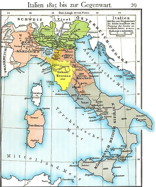
| Popis | Cartina dell'unificazione d'Italia dal 1815 fino al 1870 (il ducato di Massa e Carrara, ufficialmente indipendente fino al 1829, non è però indicato, e, non correttamente, è già considerato parte del ducato di Modena fin dal 1815) |
| Datum | |
| Zdroj | Historischer Schulatlas di F. W Putzger (1814--1913) Plate 29 from F. W. Putzgers Historischer Schul-Atlas |
| Autor | F. W Putzger (1814--1913) |
| Další verze | File:Italy unification 1815 1870.jpg |
derivative works
Díla odvozená od tohoto souboru: Italy1816cs.png Putzger, Historischer Schul-Atlas di F. W Putzger (1814--1913).
Licence
|
Toto dílo je volné také v zemích, jejichž právní řád chrání majetková autorská práva po dobu života autora a 70 let po jeho smrti.
| |
| Bylo zjištěno, že u tohoto souboru nejsou známa žádná omezení daná autorským právem a právy s ním souvisejícími. | |
Historie souboru
Kliknutím na datum a čas se zobrazí tehdejší verze souboru.
| Datum a čas | Náhled | Rozměry | Uživatel | Komentář | |
|---|---|---|---|---|---|
| současná | 19. 3. 2011, 14:40 | | 1 574 × 1 886 (600 KB) | A7N8X | cleared from the watermark image, improved compression. jpeg, making it progressively improving and quick viewing |
| 22. 1. 2009, 17:33 |  | 1 640 × 1 971 (1 007 KB) | MegaMatic | {{PD-old}} | |
| 23. 5. 2006, 13:34 |  | 1 640 × 1 971 (1,05 MB) | Massimo Macconi | Cartina dell'Italia nel 1815 tratta da Historisches Schulatlas di F. W Putzgers (1814--1913) |
Využití souboru
Tento soubor nepoužívá žádná stránka.
Globální využití souboru
Tento soubor využívají následující wiki:
- Využití na af.wikipedia.org
- Využití na als.wikipedia.org
- Využití na ast.wikipedia.org
- Využití na br.wikipedia.org
- Využití na ca.wikipedia.org
- Využití na de.wikipedia.org
- Využití na en.wikipedia.org
- Využití na fr.wikipedia.org
- Využití na hu.wikipedia.org
- Využití na it.wikipedia.org
- Využití na la.wikipedia.org
- Využití na nl.wikipedia.org
- Využití na pl.wikipedia.org
- Využití na scn.wikipedia.org
- Využití na sk.wikipedia.org
- Využití na vec.wikipedia.org
- Využití na www.wikidata.org
.jpg)