
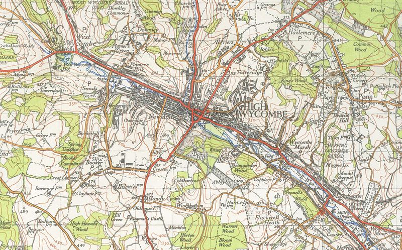
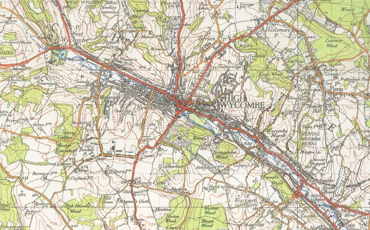
Soubor:High Wycombe map1945.jpg

Velikost tohoto náhledu: 800 × 498 pixelů. Jiná rozlišení: 320 × 199 pixelů | 640 × 399 pixelů | 1 024 × 638 pixelů | 1 280 × 798 pixelů | 2 011 × 1 253 pixelů.
Původní soubor (2 011 × 1 253 pixelů, velikost souboru: 1,94 MB, MIME typ: image/jpeg)
| Tento soubor pochází z Wikimedia Commons. Níže jsou zobrazeny informace, které obsahuje jeho tamější stránka s popisem souboru. |

|
Tento obrázek byl na Wikimedia Commons přenesen z en.wikipedia s použitím robota. Všechny informace přitom zůstaly zachovány, avšak vyžadují revizi. Nadto se zde můžou vyskytovat chyby, proto by zdejší informace neměly být považovány za spolehlivé a obrázek by se neměl používat do doby, dokud nebude zkontrolován a budou napraveny případné nedostatky. Až bude taková kontrola provedena, tato šablona může být odstraněna. Zkontrolovat nyní! |
| Popis |
English: 1 inch to the mile OS map of High_Wycombe 1945 |
| Datum | 20. ledna 2007 (datum prvotního načtení souboru) |
| Zdroj | Na Commons přenesl z en.wikipedia uživatel Oxyman pomocí nástroje CommonsHelper. |
| Autor | Původně soubor načetl Geni na projektu Wikipedie v jazyce angličtina |
Licence
This work is an Ordnance Survey map over 50 years old, which is covered by Crown Copyright which in this case expires 50 years after publication. Ordnance Survey does however ask that they be credited and that the date of publication be given.
Any ancillary rights gained through the creation of the electronic version are granted as freely usable under any circumstances.
|
This work created by the United Kingdom Government is in the public domain.
This is because it is one of the following:
HMSO has declared that the expiry of Crown Copyrights applies worldwide (ref: HMSO Email Reply)
|
 |
Původní historie souboru
Původní stránka s popisem souboru byla zde. Všechna následující uživatelská jména odkazují na projekt en.wikipedia.
- 2007-01-20 14:59 Geni 2011×1253× (2037800 bytes) 1 inch to the mile OS map of High_Wycombe 1945 {{oldOS}}
Historie souboru
Kliknutím na datum a čas se zobrazí tehdejší verze souboru.
| Datum a čas | Náhled | Rozměry | Uživatel | Komentář | |
|---|---|---|---|---|---|
| současná | 6. 10. 2009, 01:37 | | 2 011 × 1 253 (1,94 MB) | File Upload Bot (Magnus Manske) | {{BotMoveToCommons|en.wikipedia|year={{subst:CURRENTYEAR}}|month={{subst:CURRENTMONTHNAME}}|day={{subst:CURRENTDAY}}}} {{Information |Description={{en|1 inch to the mile OS map of High_Wycombe 1945 en:Category:High Wycombe}} |Source=Transferred f |
Využití souboru
Tento soubor používá následující stránka:
Globální využití souboru
Tento soubor využívají následující wiki:
- Využití na azb.wikipedia.org
- Využití na en.wikipedia.org
- Využití na pt.wikipedia.org