
Soubor:Ensanche - eixample - Barcelona.jpg
Původní soubor (2 498 × 1 659 pixelů, velikost souboru: 887 KB, MIME typ: image/jpeg)
| Tento soubor pochází z Wikimedia Commons. Níže jsou zobrazeny informace, které obsahuje jeho tamější stránka s popisem souboru. |
Popis
| Popis |
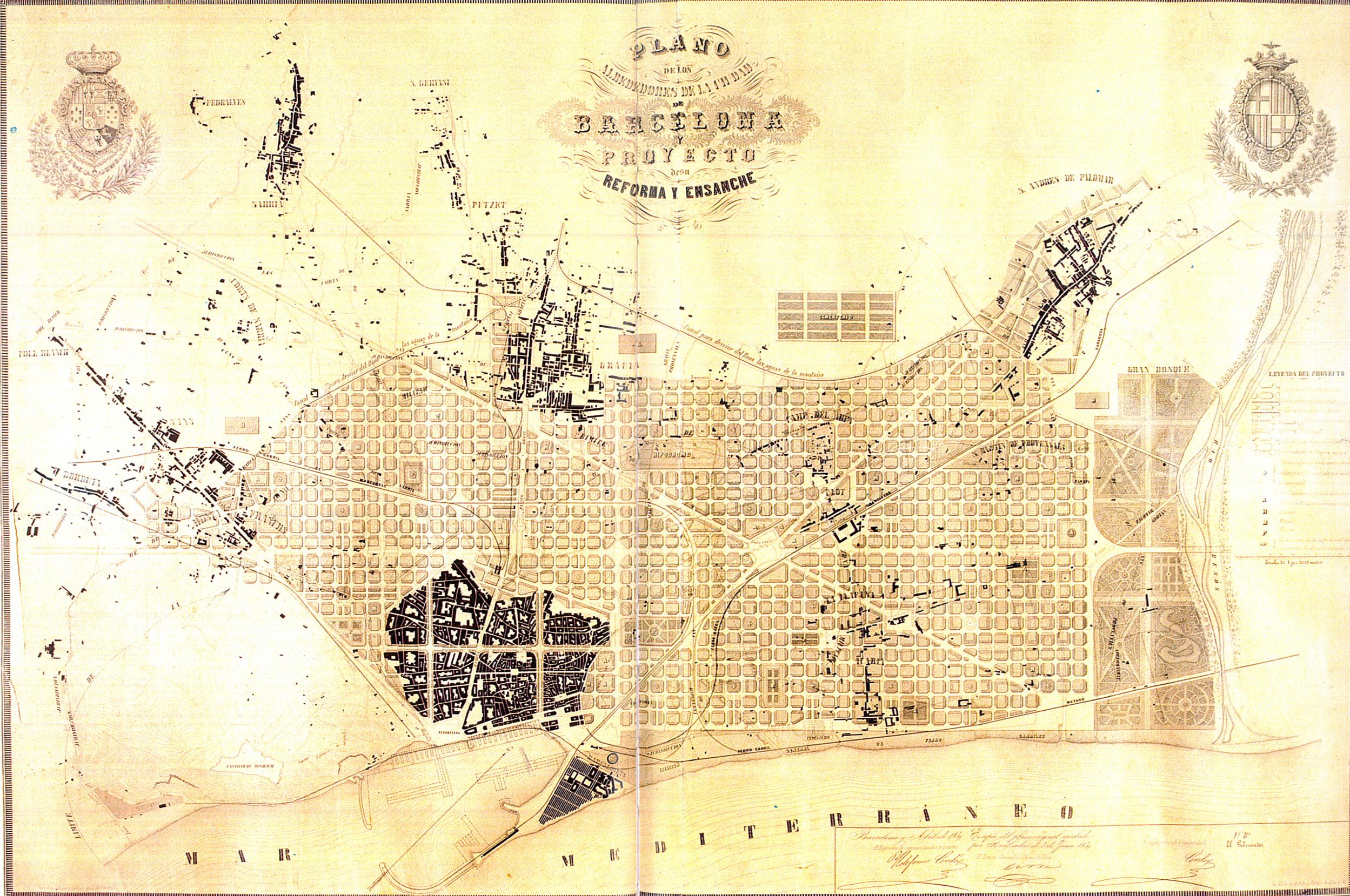
Català: Eixample de Barcelona. Pla dels voltants de la ciutat de Barcelona i del projecte per a la seva millora i ampliació, 1859.
English: Enlargement map of Barcelona. Map of the neighborhoods of the city of Barcelona and project for its improvements and enlargement, 1859.
Español: Ensanche de Barcelona. Plan de los alrededores de la ciudad de Barcelona y del proyecto para su mejora y ampliación, 1859.
Français : Aggrandissement de Barcelone. Carte des environs de la ville de Barcelone et projet d'amélioration et d'aggrandissement, 1859. |
|||||||||
| Datum | ||||||||||
| Zdroj | Museu d'Historia de la Ciutat, Barcelona. | |||||||||
| Tvůrce |
Ildefons Cerdà i Sunyer |
|||||||||
| Geotemporal data | ||||||||||
| Bounding box |
|
|||||||||
| Georeferencing | ||||||||||
| Další verze |
   |
|||||||||
Licence
|
Toto je věrná fotografická reprodukce původního dvourozměrného uměleckého díla. Ono dílo je samo volným dílem, a to z následujícího důvodu:
Oficiálním stanoviskem nadace Wikimedia Foundation je, že „věrné reprodukce dvourozměrných volných děl jsou také volné a opačná tvrzení jsou útokem na samotný koncept volných děl.“ Podrobnosti naleznete na stránce Commons:When to use the PD-Art tag. Tato fotografická reprodukce se tedy také považuje za volné dílo. Uvědomte si, že v závislosti na místních zákonech může být další užití tohoto díla ve vaší jurisdikci zakázáno či omezeno. Vizte Commons:Reuse of PD-Art photographs. {{PD-Art}} template without license parameter: please specify why the underlying work is public domain in both the source country and the United States
(Usage: {{PD-Art|1=|deathyear=''year of author's death''|country=''source country''}}, where parameter 1= can be PD-old-auto, PD-old-auto-expired, PD-old-auto-1996, PD-old-100 or similar. See Commons:Multi-license copyright tags for more information.) | ||||
Historie souboru
Kliknutím na datum a čas se zobrazí tehdejší verze souboru.
| Datum a čas | Náhled | Rozměry | Uživatel | Komentář | |
|---|---|---|---|---|---|
| současná | 12. 4. 2010, 16:01 | | 2 498 × 1 659 (887 KB) | Lironcareto | Larger image. Better resolution. Category:1850 Category:Maps of Eixample Category:Urban studies and planning Category:Maps of the history of Barcelona Category:Ildefons Cerdà |
| 14. 9. 2005, 17:55 |  | 635 × 431 (43 KB) | Tony Rotondas | *'''Title''' {{english}} Eixample of Barcelona {{spanish}} Ensanche de Barcelona. *'''Description''' {{english}} Plan of the environs of the city of Barcelona and project for its improvements and enlargement, 1859. {{spanish}} Plan de los alrededores de |
Využití souboru
Tento soubor používá následující stránka:
Globální využití souboru
Tento soubor využívají následující wiki:
- Využití na an.wikipedia.org
- Využití na ca.wikipedia.org
- Využití na de.wikipedia.org
- Využití na en.wikipedia.org
- Využití na eo.wikipedia.org
- Využití na fi.wikipedia.org
- Využití na gl.wikipedia.org
- Využití na he.wikipedia.org
- Využití na id.wikipedia.org
- Využití na it.wikipedia.org
- Využití na nl.wikipedia.org
- Využití na oc.wikipedia.org
- Využití na pl.wikipedia.org
- Využití na pt.wikipedia.org
- Využití na simple.wikipedia.org
- Využití na sq.wikipedia.org
- Využití na sr.wikipedia.org
- Využití na sv.wikipedia.org
- Využití na zh.wikipedia.org