
Soubor:De facto cantons of Rojava.png

Velikost tohoto náhledu: 725 × 599 pixelů. Jiná rozlišení: 290 × 240 pixelů | 581 × 480 pixelů | 929 × 768 pixelů | 1 239 × 1 024 pixelů | 2 000 × 1 653 pixelů.
Původní soubor (2 000 × 1 653 pixelů, velikost souboru: 268 KB, MIME typ: image/png)
| Tento soubor pochází z Wikimedia Commons. Níže jsou zobrazeny informace, které obsahuje jeho tamější stránka s popisem souboru. |

|
Tento obrázek (skupina map) by měl být vytvořen pomocí vektorové grafiky jako SVG soubor. To má několik výhod; podrobnosti najdete na stránce Commons:Media for cleanup. Je-li SVG verze tohoto obrázku již k dispozici, prosím nahrajte ji. Po nahrání nahraďte tuto šablonu šablonou {{Vector version available|jméno nového obrázku.svg}}.
|
Popis
| Popis |
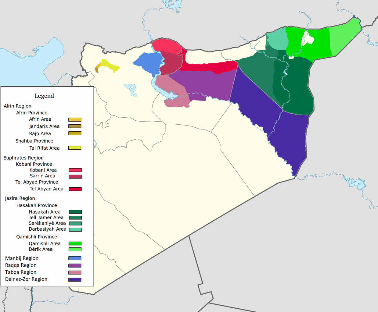
العربية: اقليم عفرين اقليم الفرات اقليم الجزيرة English: Afrin Region Euphrates Region Jazeera Region No region 한국어: 아프린 주 유프라테스 주 자제라 주 없음 |
| Datum | |
| Zdroj | Vlastní dílo |
| Autor | Editor abcdef |
| Další verze |
This image includes elements that have been taken or adapted from this file:  |
Licence
Já, držitel autorských práv k tomuto dílu, ho tímto zveřejňuji za podmínek následující licence:
Tento soubor podléhá licenci Creative Commons Uveďte autora-Zachovejte licenci 3.0 Unported
- Dílo smíte:
- šířit – kopírovat, distribuovat a sdělovat veřejnosti
- upravovat – pozměňovat, doplňovat, využívat celé nebo částečně v jiných dílech
- Za těchto podmínek:
- uveďte autora – Máte povinnost uvést autorství, poskytnout odkaz na licenci a uvést, pokud jste provedli změny. Toho můžete docílit jakýmkoli rozumným způsobem, avšak ne způsobem naznačujícím, že by poskytovatel licence schvaloval nebo podporoval vás nebo vaše užití díla.
- zachovejte licenci – Pokud tento materiál jakkoliv upravíte, přepracujete nebo použijete ve svém díle, musíte své příspěvky šířit pod stejnou nebo slučitelnou licencí jako originál.
Historie souboru
Kliknutím na datum a čas se zobrazí tehdejší verze souboru.
| Datum a čas | Náhled | Rozměry | Uživatel | Komentář | |
|---|---|---|---|---|---|
| současná | 27. 5. 2020, 10:29 | | 2 000 × 1 653 (268 KB) | AntonSamuel | Reverted to version as of 09:02, 8 April 2020 (UTC) Restoring original map without stripes per COM:OW and discussion on the Rojava talk page on Wikipedia |
| 8. 4. 2020, 11:05 |  | 2 000 × 1 653 (224 KB) | Bill497 | Reverted to version as of 08:59, 8 April 2020 (UTC) Revert vandalism. | |
| 8. 4. 2020, 11:02 |  | 2 000 × 1 653 (268 KB) | AntonSamuel | Reverted to version as of 08:51, 8 April 2020 (UTC) Third, and last warning given on user talk page. | |
| 8. 4. 2020, 10:59 |  | 2 000 × 1 653 (224 KB) | Bill497 | Reverted to version as of 08:11, 8 April 2020 (UTC) Revert vandalism for a 3rd time. User is reverting a referenced map to an unreferenced version. | |
| 8. 4. 2020, 10:51 |  | 2 000 × 1 653 (268 KB) | AntonSamuel | Reverted to version as of 17:57, 7 April 2020 (UTC) Once again, use the Rojava talk page to discuss before making reverts and don't throw around unfounded vandalism claims. Second warning on talk page given. | |
| 8. 4. 2020, 10:11 |  | 2 000 × 1 653 (224 KB) | Bill497 | Reverted to version as of 11:10, 7 April 2020 (UTC) Revert vandalism. | |
| 7. 4. 2020, 19:57 |  | 2 000 × 1 653 (268 KB) | AntonSamuel | Reverted to version as of 00:50, 7 April 2020 (UTC) Restoring viewable version - Use Rojava talk page, warning left on user talk page | |
| 7. 4. 2020, 13:10 |  | 2 000 × 1 653 (224 KB) | Bill497 | Reverted to version as of 12:33, 2 April 2020 (UTC) Revert attempted vandalism into a factually incorrect version of the map. SDF has entirely no presence in some of the dashed zones. Due to fog of war these areas are all displaced as mixed with government control. Russia is the only reliable source displaying where the government is present. | |
| 7. 4. 2020, 02:50 |  | 2 000 × 1 653 (268 KB) | AntonSamuel | Continuation from below: ...manner. Further sources are needed apart from the Russian military maps - they cannot be considered to be neutral or factually accurate without additional verification. | |
| 7. 4. 2020, 02:46 |  | 2 000 × 1 653 (218 KB) | AntonSamuel | Clearing the 50/50 paint because of the visual difficulty and for deviation from the main purpose of this map - which is to display the various subregions of the civilian administration of the de facto autonomous region, not military control agreements such as SDF-SAA/Russia and SDF-US/US-led coalition which have no known civilian aspect as of date. Please discuss the issue first and foremost on the Rojava talk page if areas with an SAA/Russian or a US presence need to be highlighted in some... |
Využití souboru
Tento soubor nepoužívá žádná stránka.
Globální využití souboru
Tento soubor využívají následující wiki:
- Využití na ar.wikipedia.org
- Využití na arz.wikipedia.org
- Využití na azb.wikipedia.org
- Využití na ca.wikipedia.org
- Využití na diq.wikipedia.org
- Využití na fa.wikipedia.org
- Využití na glk.wikipedia.org
- Využití na id.wikipedia.org
- Využití na ku.wikipedia.org
- Využití na nl.wikipedia.org
- Využití na ru.wikipedia.org
- Využití na tr.wikipedia.org
- Využití na vi.wikipedia.org
- Využití na www.wikidata.org
- Využití na zh.wikipedia.org