
Soubor:China-Gansu.png
Větší rozlišení není k dispozici
China-Gansu.png (268 × 218 pixelů, velikost souboru: 16 KB, MIME typ: image/png)
| Tento soubor pochází z Wikimedia Commons. Níže jsou zobrazeny informace, které obsahuje jeho tamější stránka s popisem souboru. |
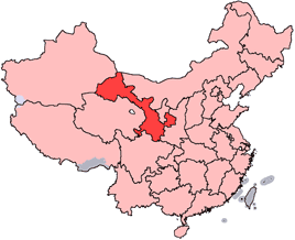
en: Location of Gansu Province in the People's Republic of China. See Locator maps of province-level divisions of the People's Republic of China for more information.
zh: 甘肅省在中華人民共和國的位置。另見Locator maps of province-level divisions of the People's Republic of China。

|
Tento dokument smí být kopírován, šířen nebo upravován podle podmínek Svobodné licence GNU pro dokumenty verze 1.2 nebo libovolné vyšší verze publikované nadací Free Software Foundation. Dokument nemá neměnné části ani texty na předním či zadním přebalu. Kopie textu licence je k dispozici v oddíle nazvaném GNU Free Documentation License. |
| Tento soubor podléhá licenci Creative Commons Uveďte autora-Zachovejte licenci 3.0 Unported | ||
| ||
| Tato licenční šablona byla k tomuto souboru přidána v rámci změny licencování. |

|
K tomuto obrázku existuje vektorová verze (v SVG). Pokud je lepší, používejte raději tu.
File:China-Gansu.png → File:Map of PRC Gansu.svg
Podrobnější informace o vektorové grafice najdete na stránce Commons:Transition to SVG. Také si můžete přečíst informace o podpoře formátu SVG v MediaWiki. |
 |
Historie souboru
Kliknutím na datum a čas se zobrazí tehdejší verze souboru.
| Datum a čas | Náhled | Rozměry | Uživatel | Komentář | |
|---|---|---|---|---|---|
| současná | 15. 7. 2005, 16:56 | | 268 × 218 (16 KB) | Schaengel89~commonswiki | transparent background |
| 5. 6. 2005, 00:39 |  | 268 × 218 (9 KB) | Ran | '''en''': Location of Gansu Province in the People's Republic of China. See Category:Locator maps of province-level divisions of the People's Republic of China for more information. '''zh''': 甘肅省在中華人民共和國的位置。另見[[:Cat |
Využití souboru
Tento soubor nepoužívá žádná stránka.
Globální využití souboru
Tento soubor využívají následující wiki:
- Využití na bn.wikipedia.org
- Využití na da.wikipedia.org
- Využití na de.wikipedia.org
- Využití na en.wikipedia.org
- Wikipedia:WikiProject Chinese provinces/Locator maps
- Xiahe County
- Yongjing County
- Daxia River
- Kongtong Mountains
- Subei Mongol Autonomous County
- Bairi Tibetan Autonomous County
- Zhuanglang County
- Huangyangchuan
- User:OldakQuill/temp
- Dunhuang Mogao International Airport
- Yongchang County
- Qingyang Airport
- Template:Gansu-geo-stub
- Xifeng, Qingyang
- Mazong Mountain
- Liancheng National Nature Reserve
- Longxi County
- Lintao County
- Min County
- Wushao Mountain
- 2008 Tibetan unrest
- Chongxin County
- Guanghe County
- Hezheng County
- Dongxiang Autonomous County
- Xihe County
- Wushan County, Gansu
- Qingshui County
- Qin'an County
- Gangu County
- Zhangjiachuan Hui Autonomous County
- Qinzhou, Tianshui
- Maiji, Tianshui
Zobrazit další globální využití tohoto souboru.