
Soubor:Castles of Munster, Lismore, Waterford-geograph-3038243.jpg

Velikost tohoto náhledu: 800 × 541 pixelů. Jiná rozlišení: 320 × 216 pixelů | 640 × 433 pixelů | 1 024 × 692 pixelů.
Původní soubor (1 024 × 692 pixelů, velikost souboru: 1,02 MB, MIME typ: image/jpeg)
| Tento soubor pochází z Wikimedia Commons. Níže jsou zobrazeny informace, které obsahuje jeho tamější stránka s popisem souboru. |
Popis
| Popis |
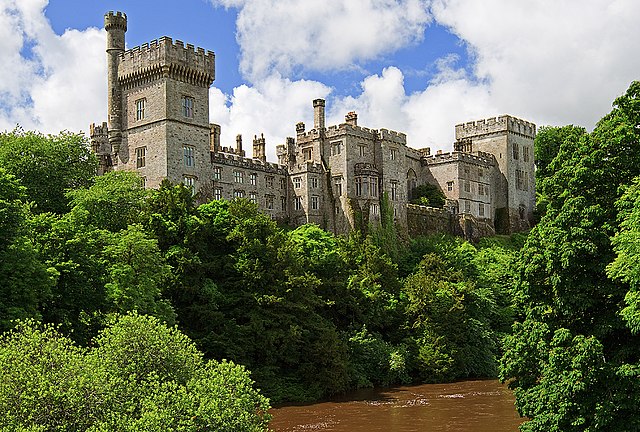
English: Castles of Munster: Lismore, Waterford. A castle has stood on this site since Prince John built a castle here above the River Blackwater in 1185. This was soon destroyed but later rebuilt, and provided a residence throughout the medieval period for the bishops of Lismore. It was damaged during the Desmond Rebellion of 1579 and was entirely rebuilt in 1621 by Sir Richard Boyle after its previous owner Sir Walter Raleigh was executed. At the end of the wars that devastated Ireland in the mid-C17 it was again in a ruinous state, and was remodelled by the 2nd Earl of Cork in the 1660s. After its neglect during the C18, a complete rebuilding was undertaken by the 6th Duke of Devonshire, whose descendants remain the current owners. The building works of 1814 totally transformed the old castle. The upper parts, the present battlements and turrets, and the majority of the features, date from this early C19 rebuilding, and it is just the lower parts of the old C17 walls that remain. There are also original gunloops in the NE tower, and in a circular tower on the west side, whilst the SE tower has older work up as far as the third storey. |
| Datum | |
| Zdroj | https://www.geograph.org.uk/photo/3038243 |
| Autor | https://www.geograph.org.uk/profile/10423 Mike Searle] |
| Uveďte autora (vyžadováno licencí) | Mike Searle / Castles of Munster: Lismore, Waterford (2) / |
| Pozice fotografa | | Tento snímek a mnohé další na: OpenStreetMap |
|---|
_heading:225.00&language=cs)
| Pozice objektu | | Tento snímek a mnohé další na: OpenStreetMap |
|---|
_heading:225.00&language=cs)
Licence

|
This image was taken from the Geograph project collection. See this photograph's page on the Geograph website for the photographer's contact details. The copyright on this image is owned by Mike Searle and is licensed for reuse under the Creative Commons Attribution-ShareAlike 2.0 license.
|
Tento soubor podléhá licenci Creative Commons Uveďte autora-Zachovejte licenci 2.0 Generic
Uveďte autora: Mike Searle
- Dílo smíte:
- šířit – kopírovat, distribuovat a sdělovat veřejnosti
- upravovat – pozměňovat, doplňovat, využívat celé nebo částečně v jiných dílech
- Za těchto podmínek:
- uveďte autora – Máte povinnost uvést autorství, poskytnout odkaz na licenci a uvést, pokud jste provedli změny. Toho můžete docílit jakýmkoli rozumným způsobem, avšak ne způsobem naznačujícím, že by poskytovatel licence schvaloval nebo podporoval vás nebo vaše užití díla.
- zachovejte licenci – Pokud tento materiál jakkoliv upravíte, přepracujete nebo použijete ve svém díle, musíte své příspěvky šířit pod stejnou nebo slučitelnou licencí jako originál.
Historie souboru
Kliknutím na datum a čas se zobrazí tehdejší verze souboru.
| Datum a čas | Náhled | Rozměry | Uživatel | Komentář | |
|---|---|---|---|---|---|
| současná | 21. 7. 2021, 12:01 | | 1 024 × 692 (1,02 MB) | Geograph Update Bot | Higher-resolution version from Geograph |
| 6. 11. 2015, 12:57 |  | 640 × 433 (384 KB) | Judithcomm | User created page with UploadWizard |
Využití souboru
Tento soubor používá následující stránka: