
Soubor:Bandeau CHGeo part2.png

Velikost tohoto náhledu: 800 × 566 pixelů. Jiná rozlišení: 320 × 226 pixelů | 640 × 452 pixelů | 1 000 × 707 pixelů.
Původní soubor (1 000 × 707 pixelů, velikost souboru: 623 KB, MIME typ: image/png)
| Tento soubor pochází z Wikimedia Commons. Níže jsou zobrazeny informace, které obsahuje jeho tamější stránka s popisem souboru. |
| Popis |
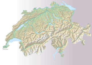
Français : Carte géographique de la Suisse (grand format) pour le bandeau du fr:portail:Géographie de la Suisse |
| Datum | |
| Zdroj | http://www.swisstopo.ch/fr/digital/over.htm |
| Autor | Romano1246, dérivé du fichier fr:Fichier:Suisse geographique.png |
| Svolení (Užití tohoto souboru) |
Source : http://www.swisstopo.ch/fr/digital/over.htm |
Licence
The data made publicly available by swisstopo may be used, distributed and made accessible. Furthermore, they may be enriched and processed and also used commercially. A reference to the source is mandatory. In the case of digital or analogue representations and publications, as well as in the case of dissemination, one of the following source references must be attached in any case:
Terms of use for free geodata and geoservices (OGD) from swisstopo
|
.svg) |
Historie souboru
Kliknutím na datum a čas se zobrazí tehdejší verze souboru.
| Datum a čas | Náhled | Rozměry | Uživatel | Komentář | |
|---|---|---|---|---|---|
| současná | 31. 10. 2009, 00:42 | | 1 000 × 707 (623 KB) | Romano1246 | {{Information |Description={{fr|1=Carte géographique de la Suisse (grand format) pour le bandeau du fr:portail:Géographie de la Suisse}} |Source=http://www.swisstopo.ch/fr/digital/over.htm |Author=Romano1246, dérivé du fichier |
Využití souboru
Tento soubor používá následující stránka:
Globální využití souboru
Tento soubor využívají následující wiki:
- Využití na fr.wikipedia.org
- Využití na uk.wikipedia.org