
Soubor:Africa-countries-central.png
Větší rozlišení není k dispozici
Africa-countries-central.png (360 × 392 pixelů, velikost souboru: 10 KB, MIME typ: image/png)
| Tento soubor pochází z Wikimedia Commons. Níže jsou zobrazeny informace, které obsahuje jeho tamější stránka s popisem souboru. |

|
K tomuto obrázku existuje vektorová verze (v SVG). Pokud je lepší, používejte raději tu.
File:Africa-countries-central.png → File:Africa-countries-central.svg
Podrobnější informace o vektorové grafice najdete na stránce Commons:Transition to SVG. Také si můžete přečíst informace o podpoře formátu SVG v MediaWiki. |
 |
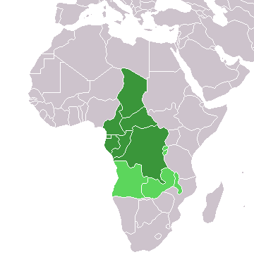
Map of countries in Central Africa.
This map was made by w:User:Joy and originally uploaded to the English Wikipedia as Africa-central-countries.png at 01:32, 28 March 2004. It is a modification of Image:BlankMap-World.png.

|
Tento dokument smí být kopírován, šířen nebo upravován podle podmínek Svobodné licence GNU pro dokumenty verze 1.2 nebo libovolné vyšší verze publikované nadací Free Software Foundation. Dokument nemá neměnné části ani texty na předním či zadním přebalu. Kopie textu licence je k dispozici v oddíle nazvaném GNU Free Documentation License. |
| Tento soubor podléhá licenci Creative Commons Uveďte autora-Zachovejte licenci 3.0 Unported | ||
| ||
| Tato licenční šablona byla k tomuto souboru přidána v rámci změny licencování. |
Historie souboru
Kliknutím na datum a čas se zobrazí tehdejší verze souboru.
| Datum a čas | Náhled | Rozměry | Uživatel | Komentář | |
|---|---|---|---|---|---|
| současná | 17. 3. 2018, 20:21 | | 360 × 392 (10 KB) | Maphobbyist | Montenegro border |
| 13. 1. 2014, 20:06 |  | 360 × 392 (10 KB) | VVVF | Some corrections | |
| 9. 7. 2011, 21:52 |  | 360 × 392 (13 KB) | Maphobbyist | South Sudan has become independent on July 9, 2011. Sudan and South Sudan are shown with the new international border between them. | |
| 5. 5. 2006, 13:10 |  | 360 × 392 (4 KB) | Hautala | optimized with png | |
| 29. 4. 2005, 20:30 |  | 360 × 392 (14 KB) | ChongDae | from en:Image:Africa-countries-central.png {{GFDL}} Category:Maps of Africa |
Využití souboru
Tento soubor nepoužívá žádná stránka.
Globální využití souboru
Tento soubor využívají následující wiki:
- Využití na fr.wikipedia.org
- Využití na he.wikipedia.org
- Využití na ht.wikipedia.org
- Využití na incubator.wikimedia.org
- Využití na is.wikipedia.org
- Využití na is.wiktionary.org
- Využití na kaa.wikipedia.org
- Využití na kbd.wikipedia.org
- Využití na ko.wikipedia.org
- Využití na ky.wikipedia.org
- Využití na mg.wikipedia.org
- Využití na nl.wikipedia.org
- Využití na nn.wikipedia.org
- Využití na oc.wikipedia.org
- Využití na pl.wikipedia.org
- Využití na ru.wikipedia.org
- Využití na sl.wikipedia.org
- Využití na sv.wikipedia.org
- Využití na sv.wikinews.org
- Využití na szl.wikipedia.org
- Využití na tk.wikipedia.org
- Využití na tt.wikipedia.org
- Využití na uk.wikipedia.org
- Využití na uz.wikipedia.org
- Využití na wo.wikipedia.org
- Využití na yi.wikipedia.org