
Soubor:910 ftrichardson.png

Větší rozlišení není k dispozici
910_ftrichardson.png (533 × 316 pixelů, velikost souboru: 234 KB, MIME typ: image/png)
| Tento soubor pochází z Wikimedia Commons. Níže jsou zobrazeny informace, které obsahuje jeho tamější stránka s popisem souboru. |
Popis
| Popis |
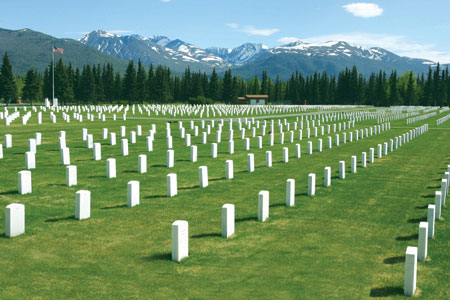
English: Fort Richardson National Cemetery, Fort Richardson (now part of Joint Base Elmendorf-Richardson), Anchorage, Alaska, United States Geological Survey GNIS Feature ID=2061976, Elevation: 367 feet (112 m). |
| Zdroj |
Image: http://www.cem.va.gov/cem/images/cemphotos/910_ftrichardson.jpg Website: http://www.cem.va.gov/CEM/cems/nchp/ftrichardson.asp |
| Autor | United States Department of Veterans Affairs |
|
This is an image of a place or building that is listed on the National Register of Historic Places in the United States of America. Its reference number is 12000056. |
| Pozice fotografa | | Tento snímek a mnohé další na: OpenStreetMap |
|---|
Licence
| This image is a work of a United States Department of Veterans Affairs employee, taken or made as part of that person's official duties. As a work of the U.S. federal government, the image is in the public domain. |  |
Historie souboru
Kliknutím na datum a čas se zobrazí tehdejší verze souboru.
| Datum a čas | Náhled | Rozměry | Uživatel | Komentář | |
|---|---|---|---|---|---|
| současná | 26. 8. 2008, 14:50 | | 533 × 316 (234 KB) | LeheckaG | {{Information |Description={{en|1=Fort Richardson National Cemetery {{Cite gnis|2061976|Fort Richardson National Cemetery (Anchorage)}} }} |Source=Image: http://www.cem.va.gov/cem/images/cemphotos/910_ftrichardson.j |
Využití souboru
Tento soubor používá následující stránka:
Globální využití souboru
Tento soubor využívají následující wiki:
- Využití na en.wikipedia.org
- Využití na fr.wikipedia.org
- Využití na ja.wikipedia.org
- Využití na www.wikidata.org