
Soubor:1776 Rennell - Dury Wall Map of Bihar and Bengal, India - Geographicus - BaharBengal-dury-1776.jpg

Původní soubor (9 106 × 6 000 pixelů, velikost souboru: 16,86 MB, MIME typ: image/jpeg)
| Tento soubor pochází z Wikimedia Commons. Níže jsou zobrazeny informace, které obsahuje jeho tamější stránka s popisem souboru. |
Popis
| Upozornění | Některé prohlížeče mohou mít problémy se zobrazením tohoto souboru v plné velikosti: Tento obrázek má neobvykle vysoké rozlišení, takže se nemusí načíst správně nebo může způsobit zamrznutí prohlížeče. |
|---|
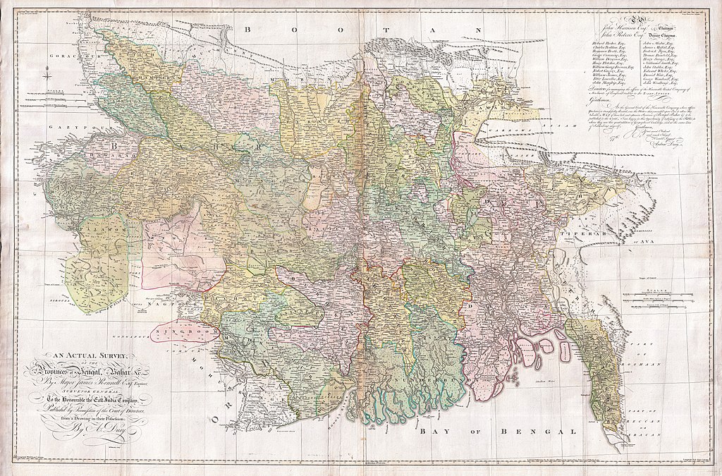
| Titul |
An Actual Survey, of the Provinces of Bengal, Bahar & c. by Major James Rennell Esq. Engineer to the Honorable the East India Company. Published by Permission of the Court of Directors from a Drawing in their Possession by A. Dury. |
|||||||||
| Popis |
English: An altogether spectacular wall sized map of those parts of Bengal and Bihar, India. Follows the course of the Ganges River from Varanasi (Benares) eastward to the Ganges Delta and the Bay of Bengal. Includes Varanasi (Benares), Dacca (Dahka, Bengladesh), and Patna among many other important Indian cities. Bounded on the north by the Himalaya Mountains and the border with Bhutan. One of the first accurate maps of the interior of India. Laid out from primary surveys done by James Rennell, the first modern cartographer to map the interior of India. Notes cities, markets, battlefields, fortresses, roads, rivers, offers political commentary, and features some geographical references. Elaborate title in the lower left quadrant. Upper right quadrant features a dedication and letter of thanks written by Andrew Dury, the publisher, to the board of the East India Company. This is the first edition of this rare map – 1776 – as published by Dury. Later editions were published by Sayer and Bennet and by Laurie and Whittle.
Another high quality digitisation is available at the David Rumsey Historical Map Collection: [1] This map was published by Laurie and Whittle, as mentioned in the description by Geographicus for the 1776 map, in 1794. Regions are demarcated in coloured outlines instead of filled colours. A higher quality digitisation than that of Geographicus. Contains parts that are missing at the central vertical fold in the Geographicus digitisation of the 1776 map. Viewable in online Flash viewer and downloadable in MrSID format. |
|||||||||
| Datum | (dated) | |||||||||
| Zdroj |
The Bengal Atlas ??, Rennell, James, (1779 first edition)
|
|||||||||
| Tvůrce | ||||||||||
| Geotemporal data | ||||||||||
| Bounding box |
|
|||||||||
| Georeferencing | ||||||||||
| Archival data | ||||||||||
| Inventární číslo |
Geographicus link: BaharBengal-dury-1776 |
|||||||||
| Rozměry | výška: 39 in (99 cm); šířka: 59 in (149,8 cm) | |||||||||

|
Tento obrázek byl posouzen podle kritérií pro hodnotné obrázky a je považován za nejhodnotnější obrázek na Commons v rámci pole působnosti: Old maps of Bengal from 1776 by Major James Rennell. Nominační stránku si můžete prohlédnout na Commons:Valued image candidates/1776 Rennell - Dury Wall Map of Bihar and Bengal, India - Geographicus - BaharBengal-dury-1776.jpg. |
Licence
|
Toto dílo je volné také v zemích, jejichž právní řád chrání majetková autorská práva po dobu života autora a 100 let po jeho smrti. Toto dílo je ve Spojených státech amerických dílem volným (public domain), protože tam bylo registrováno u U.S. Copyright Office nebo zveřejněno před 1. lednem 1929. | |
| Bylo zjištěno, že u tohoto souboru nejsou známa žádná omezení daná autorským právem a právy s ním souvisejícími. | |
Historie souboru
Kliknutím na datum a čas se zobrazí tehdejší verze souboru.
| Datum a čas | Náhled | Rozměry | Uživatel | Komentář | |
|---|---|---|---|---|---|
| současná | 17. 3. 2011, 10:39 | | 9 106 × 6 000 (16,86 MB) | BotMultichill | {{subst:User:Multichill/Geographicus |link=http://www.geographicus.com/P/AntiqueMap/BaharBengal-dury-1776 |product_name=1776 Rennell - Dury Wall Map of Bihar and Bengal, India |map_title=An Actual Survey, of the Provinces of Bengal, Bahar & c. by Major Ja |
Využití souboru
Tento soubor používá následující stránka:
Globální využití souboru
Tento soubor využívají následující wiki:
- Využití na ar.wikipedia.org
- Využití na as.wikipedia.org
- Využití na azb.wikipedia.org
- Využití na bn.wikipedia.org
- Využití na bn.wikisource.org
- Využití na el.wikipedia.org
- Využití na en.wikipedia.org
- Využití na es.wikipedia.org
- Využití na fa.wikipedia.org
- Využití na fr.wikipedia.org
- Využití na hi.wikipedia.org
- Využití na ja.wikipedia.org
- Využití na ko.wikipedia.org
- Využití na ml.wikipedia.org
- Využití na mt.wikipedia.org
- Využití na ne.wikipedia.org
- Využití na nl.wikipedia.org
- Využití na pnb.wikipedia.org
- Využití na sa.wikipedia.org
Zobrazit další globální využití tohoto souboru.