
Soubor:The Man in the High Castle Plausible World Map.png
Velikost tohoto náhledu: 800 × 579 pixelů. Jiná rozlišení: 320 × 232 pixelů | 640 × 463 pixelů | 1 024 × 741 pixelů | 1 280 × 926 pixelů | 1 577 × 1 141 pixelů.
Původní soubor (1 577 × 1 141 pixelů, velikost souboru: 400 KB, MIME typ: image/png)
| Tento soubor pochází z Wikimedia Commons. Níže jsou zobrazeny informace, které obsahuje jeho tamější stránka s popisem souboru. |

|
Tato mapa, stejně jako ostatní fiktivní mapy, je fiktivní, nebo velmi nepřesná (například skrz anachronismus) a nelze ji používat jako doprovodný prvek v kontextu skutečného světa, ať už současného či historického. Může nést vizuální znaky (barvy, pozice komponentů), které jsou podobné oficiálním mapám, nicméně se nejedná o oficiální mapu a není jako taková uznána. |
[[Category:]]
Popis
| Popis |
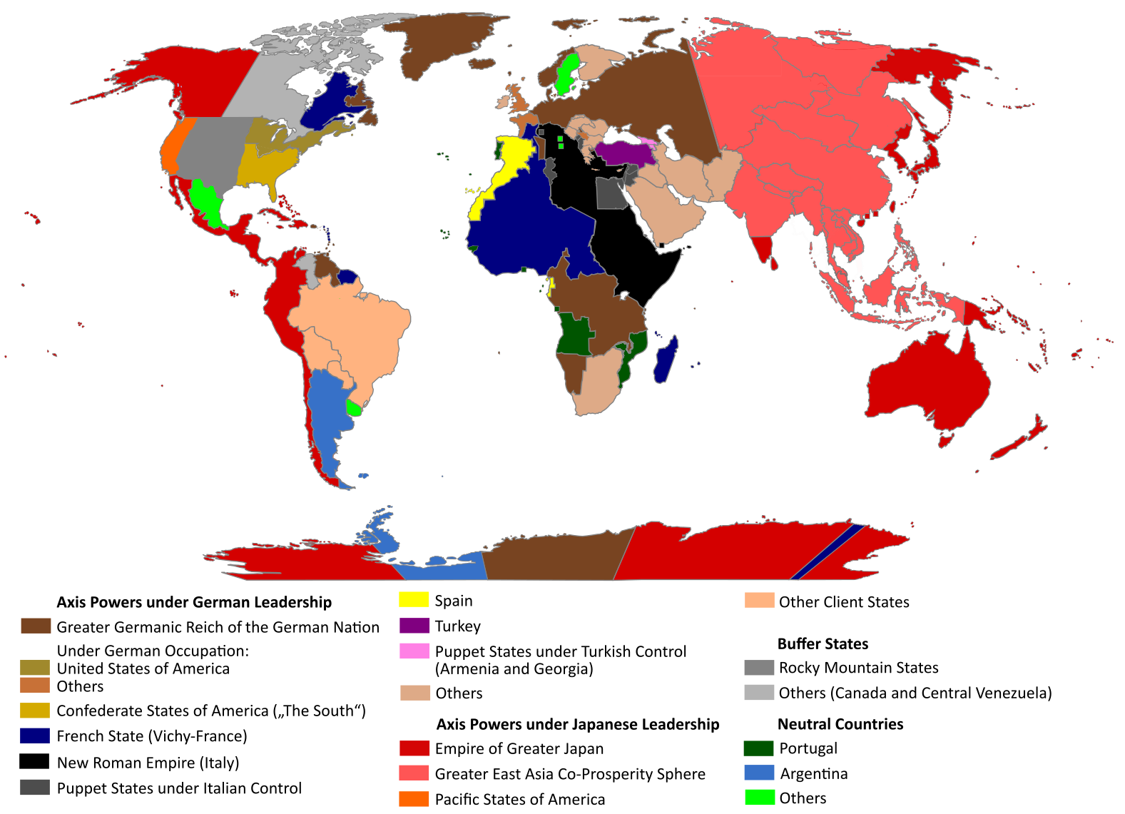
English: "The Man in the High Castle" is an alternate history novel by Philip K. Dick. It is set in a world in which the Axis powers have won World War II. This map is inspired by Dick's story and shows a plausible division of the world between Nazi Germany (dark brown), Imperial Japan (dark red) and their respective allies. However, the map is much more precise than the book describes.
https://web.archive.org/web/20191202005150/http://www.high-castle-world-map.com:80/ |
| Datum | |
| Zdroj | Vlastní dílo |
| Autor | RobintheHighCastle |
| Svolení (Užití tohoto souboru) |
Licence
Já, držitel autorských práv k tomuto dílu, ho tímto zveřejňuji za podmínek následující licence:
Tento soubor podléhá licenci Creative Commons Uveďte autora-Zachovejte licenci 4.0 International
- Dílo smíte:
- šířit – kopírovat, distribuovat a sdělovat veřejnosti
- upravovat – pozměňovat, doplňovat, využívat celé nebo částečně v jiných dílech
- Za těchto podmínek:
- uveďte autora – Máte povinnost uvést autorství, poskytnout odkaz na licenci a uvést, pokud jste provedli změny. Toho můžete docílit jakýmkoli rozumným způsobem, avšak ne způsobem naznačujícím, že by poskytovatel licence schvaloval nebo podporoval vás nebo vaše užití díla.
- zachovejte licenci – Pokud tento materiál jakkoliv upravíte, přepracujete nebo použijete ve svém díle, musíte své příspěvky šířit pod stejnou nebo slučitelnou licencí jako originál.
Historie souboru
Kliknutím na datum a čas se zobrazí tehdejší verze souboru.
| Datum a čas | Náhled | Rozměry | Uživatel | Komentář | |
|---|---|---|---|---|---|
| současná | 29. 10. 2021, 16:55 | | 1 577 × 1 141 (400 KB) | Saltner67 | Added the portoguese colonies Cabinda and Ajuda since they would still have existed in this world. |
| 20. 6. 2021, 10:05 |  | 1 613 × 1 143 (417 KB) | Gernsback67 | Changed "Greater Asian Co-Prosperity Sphere" in "Greater East Asia Co-Prosperity Sphere", which is correct. | |
| 16. 10. 2020, 17:30 |  | 1 611 × 1 138 (418 KB) | Saltner67 | Restored the latest version. Please do not revert any changes, which have been made to this file so far, without any communication with the author of the map. All changes made here have been initialized by the author and are a result of the same process which has led to the creation of the map in the first place. | |
| 16. 10. 2020, 10:25 |  | 1 621 × 1 137 (392 KB) | Gooduserdude | RV Original research: this image is based on a source and should not be altered | |
| 29. 3. 2020, 16:15 |  | 1 611 × 1 138 (418 KB) | Saltner67 | Improved the accuracy of borders of Mongolia and Manchukuo. | |
| 27. 3. 2020, 17:58 |  | 1 607 × 1 138 (418 KB) | Saltner67 | Enlarged Manchukuo and added the puppet states of Yakutia and Krasnoyarsk/Irkutsk after more research on Kantokuen. | |
| 12. 3. 2020, 21:07 |  | 1 612 × 1 143 (411 KB) | Saltner67 | Moved the Swiss Canton of Valais from Germany to Italy, as has been prepared in the plans for Operation Tannenbaum. | |
| 8. 2. 2020, 20:57 |  | 1 605 × 1 139 (411 KB) | Saltner67 | Reinserted the territories of Tunisia,Greece, Crete and Cyprus after research on the Italian plannings and Greece in WWII. | |
| 21. 11. 2019, 15:21 |  | 1 611 × 1 133 (409 KB) | Gernsback67 | Enlarged Mongolia again after more research on pan-mongolism. | |
| 21. 9. 2019, 17:13 |  | 1 610 × 1 137 (408 KB) | Saltner67 | unified Mongolia, enlarged Manchukuo and Thailand, re-inserted the real-life borders of Laos and Vietnam after research on Demchugdongrub, Kantokuen, Thailand and Indochina in WWII |
Využití souboru
Tento soubor používá následující stránka:
Globální využití souboru
Tento soubor využívají následující wiki:
- Využití na ar.wikipedia.org
- Využití na da.wikipedia.org
- Využití na de.wikipedia.org
- Využití na en.wikipedia.org
- Využití na en.wikiquote.org
- Využití na es.wikipedia.org
- Využití na gl.wikipedia.org
- Využití na he.wikipedia.org
- Využití na hu.wikipedia.org
- Využití na it.wikipedia.org
- Využití na ja.wikipedia.org
- Využití na ko.wikipedia.org
- Využití na lt.wikipedia.org
- Využití na nl.wikipedia.org
- Využití na pl.wikipedia.org
- Využití na pt.wikipedia.org
- Využití na ro.wikipedia.org
- Využití na ru.wikipedia.org
- Využití na th.wikipedia.org
- Využití na uk.wikipedia.org
- Využití na zh-classical.wikipedia.org
- Využití na zh.wikipedia.org