
Soubor:Sulawesi map.PNG

Velikost tohoto náhledu: 543 × 599 pixelů. Jiná rozlišení: 217 × 240 pixelů | 435 × 480 pixelů | 696 × 768 pixelů | 928 × 1 024 pixelů | 1 492 × 1 647 pixelů.
Původní soubor (1 492 × 1 647 pixelů, velikost souboru: 83 KB, MIME typ: image/png)
| Tento soubor pochází z Wikimedia Commons. Níže jsou zobrazeny informace, které obsahuje jeho tamější stránka s popisem souboru. |
Popis
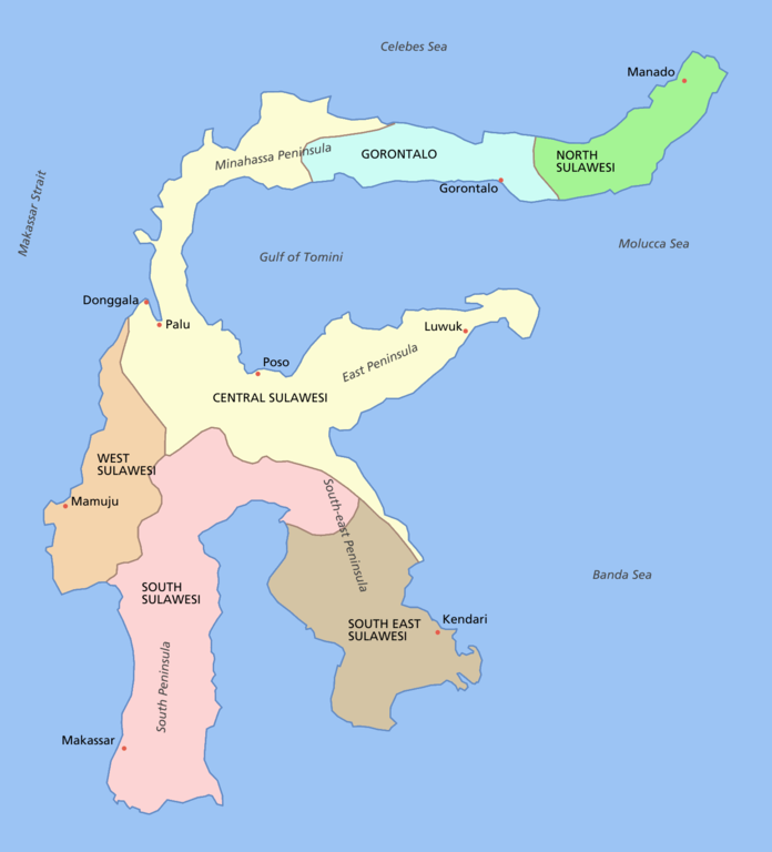
Sulawesi showing provinces, their capital cities, a few other cities and some surrounding areas of water. Note that there are other islands in this area which are not shown as this is a map of Sulawesi island itself.
For a blank map see Image:Sulawesi blank.PNG
derivative works
Díla odvozená od tohoto souboru: Sulawesi map id.png
Licence

|
Tento dokument smí být kopírován, šířen nebo upravován podle podmínek Svobodné licence GNU pro dokumenty verze 1.2 nebo libovolné vyšší verze publikované nadací Free Software Foundation. Dokument nemá neměnné části ani texty na předním či zadním přebalu. Kopie textu licence je k dispozici v oddíle nazvaném GNU Free Documentation License. |
| Tento soubor podléhá licenci Creative Commons Uveďte autora-Zachovejte licenci 3.0 Unported | ||
| ||
| Tato licenční šablona byla k tomuto souboru přidána v rámci změny licencování. |
Historie souboru
Kliknutím na datum a čas se zobrazí tehdejší verze souboru.
| Datum a čas | Náhled | Rozměry | Uživatel | Komentář | |
|---|---|---|---|---|---|
| současná | 11. 3. 2006, 14:11 | | 1 492 × 1 647 (83 KB) | Roke~commonswiki | fixed borders of provinces |
| 11. 3. 2006, 06:55 |  | 1 492 × 1 647 (82 KB) | Roke~commonswiki | Sulawesi showing provinces, their capital cities, a few other cities and some surrounding areas of water. Note that there are other islands in this area which are not shown as this is a map of Sulawesi island itself. Category:Sulawesi [[Category:Maps |
Využití souboru
Tento soubor používá následující stránka:
Globální využití souboru
Tento soubor využívají následující wiki:
- Využití na af.wikipedia.org
- Využití na bg.wikipedia.org
- Využití na bn.wikipedia.org
- Využití na bug.wikipedia.org
- Využití na ca.wikipedia.org
- Využití na ceb.wikipedia.org
- Využití na cy.wikipedia.org
- Využití na el.wikipedia.org
- Využití na en.wikipedia.org
- Využití na es.wikipedia.org
- Využití na eu.wikipedia.org
- Využití na fa.wikipedia.org
- Využití na fi.wikipedia.org
- Využití na fr.wikipedia.org
- Využití na ga.wikipedia.org
- Využití na gl.wikipedia.org
- Využití na gl.wiktionary.org
- Využití na hi.wikipedia.org
- Využití na hu.wikipedia.org
- Využití na id.wiktionary.org
- Využití na ilo.wikipedia.org
- Využití na is.wikipedia.org
- Využití na it.wikipedia.org
- Využití na ja.wikipedia.org
- Využití na kk.wikipedia.org
- Využití na km.wikipedia.org
- Využití na la.wikipedia.org
- Využití na map-bms.wikipedia.org
- Využití na mi.wikipedia.org
- Využití na ml.wikipedia.org
- Využití na mrj.wikipedia.org
- Využití na mr.wikipedia.org
Zobrazit další globální využití tohoto souboru.