
Soubor:Siege of Homs Map.svg

Velikost tohoto PNG náhledu tohoto SVG souboru: 588 × 599 pixelů. Jiná rozlišení: 235 × 240 pixelů | 471 × 480 pixelů | 753 × 768 pixelů | 1 005 × 1 024 pixelů | 2 009 × 2 048 pixelů | 883 × 900 pixelů.
Původní soubor (soubor SVG, nominální rozměr: 883 × 900 pixelů, velikost souboru: 4,91 MB)
| Tento soubor pochází z Wikimedia Commons. Níže jsou zobrazeny informace, které obsahuje jeho tamější stránka s popisem souboru. |
Popis
| Popis |
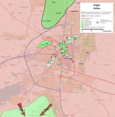
English: Map showing the current strategic situation in Homs as of January 2014.
Red represents area under Government control. Green represents Opposition control. |
||||
| Datum | |||||
| Zdroj | Vlastní dílo | ||||
| Autor | MrPenguin20 | ||||
| Další verze |
|


.svg)

.png)


.svg)


.svg)


_Territory_Change_2014-2016.gif)

_(within_Northern_Syria).svg)


.png)
.svg)


_map.png)
.svg)


.svg)


Licence
| This work contains information from OpenStreetMap, which is made available under the Open Database License (ODbL).
The ODbL does not require any particular license for maps produced from ODbL data. Prior to 1 August 2020, map tiles produced by the OpenStreetMap Foundation were licensed under the CC-BY-SA-2.0 license. Maps produced by other people may be subject to other licences. |
Já, držitel autorských práv k tomuto dílu, ho tímto zveřejňuji za podmínek následující licence:
Tento soubor podléhá licenci Creative Commons Uveďte autora-Zachovejte licenci 3.0 Unported
- Dílo smíte:
- šířit – kopírovat, distribuovat a sdělovat veřejnosti
- upravovat – pozměňovat, doplňovat, využívat celé nebo částečně v jiných dílech
- Za těchto podmínek:
- uveďte autora – Máte povinnost uvést autorství, poskytnout odkaz na licenci a uvést, pokud jste provedli změny. Toho můžete docílit jakýmkoli rozumným způsobem, avšak ne způsobem naznačujícím, že by poskytovatel licence schvaloval nebo podporoval vás nebo vaše užití díla.
- zachovejte licenci – Pokud tento materiál jakkoliv upravíte, přepracujete nebo použijete ve svém díle, musíte své příspěvky šířit pod stejnou nebo slučitelnou licencí jako originál.
Historie souboru
Kliknutím na datum a čas se zobrazí tehdejší verze souboru.
| Datum a čas | Náhled | Rozměry | Uživatel | Komentář | |
|---|---|---|---|---|---|
| současná | 3. 8. 2018, 21:35 | | 883 × 900 (4,91 MB) | Rr016 | Correction: rebels did not control that much north of Homs |
| 10. 12. 2017, 22:36 |  | 883 × 900 (4,92 MB) | Kami888 | Made several changes to improve presentation, ask on talk page if any questions. | |
| 9. 10. 2017, 19:28 |  | 883 × 900 (4,82 MB) | Rr016 | Fixes: added Shamas district, labeled more districts, fixed date of SAA offensive south of Homs, adjusted Bayada frontlines. | |
| 8. 10. 2017, 20:07 |  | 883 × 900 (4,82 MB) | Rr016 | Major overhaul, inspired by Kami88's Battle of Qalamoun.svg layout. Map now shows all territory lost by opposition from 2012 - 2017. Used https://www.facebook.com/the.arab.chronicle/photos/a.454685571308535.1073741828.453010751476017/524550737655351/?t... | |
| 11. 5. 2014, 03:14 |  | 883 × 900 (4,77 MB) | MrPenguin20 | Updated map to show current areas of control (will update further to show progression of siege). | |
| 21. 4. 2014, 01:02 |  | 883 × 900 (4,77 MB) | MrPenguin20 | Update following recent offensives. | |
| 8. 4. 2014, 23:14 |  | 883 × 900 (4,77 MB) | MrPenguin20 | Changed Dar al-Kabirah to contested. | |
| 14. 2. 2014, 00:53 |  | 883 × 900 (4,77 MB) | MrPenguin20 | Updated map in line with https://pbs.twimg.com/media/BgWebW3CcAAJLbS.jpg:large | |
| 4. 2. 2014, 17:35 |  | 883 × 900 (4,77 MB) | MrPenguin20 | Removed "Homs" from center of map. Reworked frontlines in line with map visible at http://online.wsj.com/news/articles/SB10001424052702303277704579346833918268994?mg=reno64-wsj&url=http%3A%2F%2Fonline.wsj.com%2Farticle%2FSB10001424052702303277704579346... | |
| 30. 1. 2014, 21:09 |  | 883 × 900 (4,77 MB) | MrPenguin20 | Expanded area of opposition control north of Homs. |
Využití souboru
Tento soubor používá následující stránka:
Globální využití souboru
Tento soubor využívají následující wiki:
- Využití na ar.wikipedia.org
- Využití na azb.wikipedia.org
- Využití na be.wikipedia.org
- Využití na en.wikipedia.org
- Využití na es.wikipedia.org
- Využití na fa.wikipedia.org
- Využití na fr.wikipedia.org
- Využití na hu.wikipedia.org
- Využití na it.wikipedia.org
- Využití na ja.wikipedia.org
- Využití na nl.wikipedia.org
- Využití na pl.wikipedia.org
- Využití na ru.wikipedia.org
- Využití na tr.wikipedia.org
- Využití na www.wikidata.org
- Využití na zh.wikipedia.org