
Soubor:Nye fylker - regjeringen.no.svg

Původní soubor (soubor SVG, nominální rozměr: 515 × 689 pixelů, velikost souboru: 85 KB)
| Tento soubor pochází z Wikimedia Commons. Níže jsou zobrazeny informace, které obsahuje jeho tamější stránka s popisem souboru. |
Popis
| Popis |
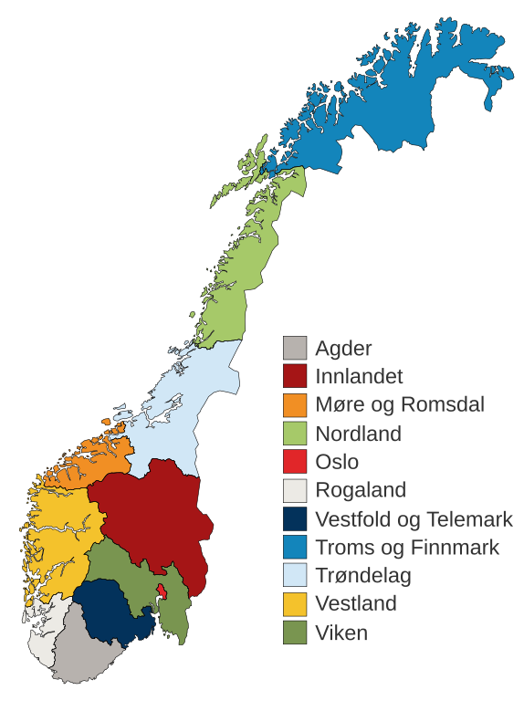
English: Municipal and regional reform: "On 8 June 2017, the Storting decided the following merger of counties". Illustration included.
Norsk bokmål: Kommune- og regionreform: "Stortinget vedtok 8. juni 2017 følgende sammenslåinger av fylker". Medfølgende kart-illustrasjon. |
|||
| Datum | ||||
| Zdroj |
Tento soubor byl odvozen z: Fylkeskart-regionreform.jpg |
|||
| Autor | Furfur | |||
| Svolení (Užití tohoto souboru) |
|
|||
| Další verze |
|
|||
| SVG vývoj | Tento vektorový obrázek byl vytvořen programem Adobe Illustrator |


Historie souboru
Kliknutím na datum a čas se zobrazí tehdejší verze souboru.
| Datum a čas | Náhled | Rozměry | Uživatel | Komentář | |
|---|---|---|---|---|---|
| současná | 3. 1. 2020, 03:54 | | 515 × 689 (85 KB) | Furfur | Korr. |
| 3. 1. 2020, 03:42 |  | 515 × 689 (85 KB) | Furfur | == {{int:filedesc}} == {{Information |Description={{User:Medium69/Traduction}} {{no|1=Kommune- og regionreform: "Stortinget vedtok 8. juni 2017 følgende sammenslåinger av fylker". Medfølgende kart-illustrasjon. }} |Source={{Derived from|Fylkeskart-regionreform.jpg}} *[https://www.regjeringen.no/no/tema/kommuner-og-regioner/regionreform/regionreform/nye-fylker/id2548426/ Nye fylker] |Date=2020-01-03 |Author={{U|Furfur}} |Permission={{self|GFDL|cc-by-sa-4.0}} |Other versions={{bva|Fylkeskart-re... |
Využití souboru
Tento soubor nepoužívá žádná stránka.
Globální využití souboru
Tento soubor využívají následující wiki:
- Využití na bs.wikipedia.org
- Využití na ca.wikipedia.org
- Využití na da.wikipedia.org
- Využití na el.wikipedia.org
- Využití na en.wikipedia.org
- Využití na es.wikipedia.org
- Využití na fa.wikipedia.org
- Využití na fi.wikipedia.org
- Využití na he.wikipedia.org
- Využití na hu.wikipedia.org
- Využití na is.wikipedia.org
- Využití na it.wikipedia.org
- Využití na jv.wikipedia.org
- Využití na ko.wikipedia.org
- Využití na nl.wikipedia.org
- Využití na nn.wikipedia.org
Zobrazit další globální využití tohoto souboru.