
Soubor:NE AZ-NW NM NASA.jpg

Původní soubor (990 × 830 pixelů, velikost souboru: 645 KB, MIME typ: image/jpeg)
| Tento soubor pochází z Wikimedia Commons. Níže jsou zobrazeny informace, které obsahuje jeho tamější stránka s popisem souboru. |
Popis
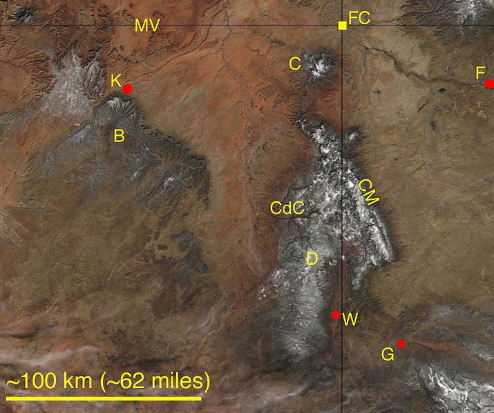
A cropped, labeled, and lower-resolution adaptation from a NASA satellite image, Visible Earth (file GrandCanyon.A2002019.1820.250m.jpg at http://visibleearth.nasa.gov). Parts of northeastern Arizona and northwestern New Mexico, including the Four Corners Monument (FC), are shown. Some higher elevations have a dust of snow. Labeled natural features are the Chuska Mountains (CM), the Carrizo Mountains (C), Monument Valley Navajo Tribal Park (MV), Black Mesa (B), Canyon de Chelly National Monument (CdC), and the Defiance Uplift (D). Labeled towns are Farmington, New Mexico (F), Gallup, New Mexico (G), Window Rock, Arizona (W), and Kayenta, Arizona (K).
Licence
| This file is in the public domain in the United States because it was solely created by NASA. NASA copyright policy states that "NASA material is not protected by copyright unless noted". (See Template:PD-USGov, NASA copyright policy page or JPL Image Use Policy.) | ||
 |
Warnings:
|
Historie souboru
Kliknutím na datum a čas se zobrazí tehdejší verze souboru.
| Datum a čas | Náhled | Rozměry | Uživatel | Komentář | |
|---|---|---|---|---|---|
| současná | 18. 7. 2006, 21:48 | | 990 × 830 (645 KB) | Omphacite~commonswiki | A cropped, labeled, and lower-resolution adaptation from a NASA satellite image, Visible Earth (file GrandCanyon.A2002019.1820.250m.jpg at http://visibleearth.nasa.gov). Parts of northeastern Arizona and northwestern New Mexico, including the Four Corners |
Využití souboru
Tento soubor používají následující 2 stránky:
Globální využití souboru
Tento soubor využívají následující wiki:
- Využití na ceb.wikipedia.org
- Využití na en.wikipedia.org
- Využití na es.wikipedia.org
- Využití na fa.wikipedia.org
- Využití na it.wikipedia.org
- Využití na www.wikidata.org