
Soubor:Mare Tranquillitatis map.jpg
Větší rozlišení není k dispozici
Mare_Tranquillitatis_map.jpg (343 × 344 pixelů, velikost souboru: 69 KB, MIME typ: image/jpeg)
| Tento soubor pochází z Wikimedia Commons. Níže jsou zobrazeny informace, které obsahuje jeho tamější stránka s popisem souboru. |
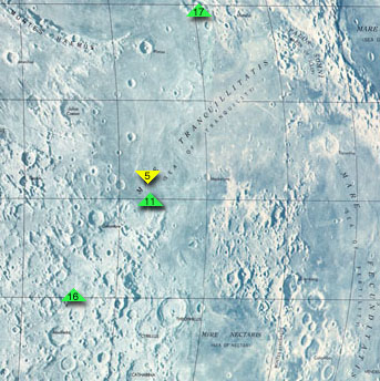
Popis
Map of Mare Tranquillitatis, cropped from http://www.jpl.nasa.gov/history/60s/Surveyor7_1968.htm.
The colored arrows indicate the landing sites of Apollo 11, the first manned moon mission, Apollo 17, Apollo 16, and Surveyor 5. To the southeast is Mare Fecunditatis, to the northeast is Mare Crisium, and to the south is Mare Nectaris.
Secondary source: http://en.wikipedia.org/wiki/Image:Mare_Tranquillitatis_map.jpg
Licence
| This file is in the public domain in the United States because it was solely created by NASA. NASA copyright policy states that "NASA material is not protected by copyright unless noted". (See Template:PD-USGov, NASA copyright policy page or JPL Image Use Policy.) | ||
 |
Warnings:
|
Historie souboru
Kliknutím na datum a čas se zobrazí tehdejší verze souboru.
| Datum a čas | Náhled | Rozměry | Uživatel | Komentář | |
|---|---|---|---|---|---|
| současná | 26. 8. 2005, 01:00 | | 343 × 344 (69 KB) | Mattes | new |
Využití souboru
Tento soubor používá následující stránka:
Globální využití souboru
Tento soubor využívají následující wiki:
- Využití na af.wikipedia.org
- Využití na bg.wikipedia.org
- Využití na da.wikipedia.org
- Využití na de.wikipedia.org
- Využití na en.wikipedia.org
- Využití na es.wikipedia.org
- Využití na fa.wikipedia.org
- Využití na fi.wikipedia.org
- Využití na fr.wikipedia.org
- Využití na he.wikipedia.org
- Využití na it.wikipedia.org
- Využití na ka.wikipedia.org
- Využití na ko.wikipedia.org
- Využití na lb.wikipedia.org
- Využití na nl.wikipedia.org
- Využití na pl.wikipedia.org
- Využití na pt.wikipedia.org
- Využití na ro.wikipedia.org
- Využití na ru.wikipedia.org
- Využití na simple.wikipedia.org
- Využití na sv.wikipedia.org
- Využití na zh.wikipedia.org