
Soubor:Mare Boreum Map.JPG
Větší rozlišení není k dispozici
Mare_Boreum_Map.JPG (479 × 478 pixelů, velikost souboru: 35 KB, MIME typ: image/jpeg)
| Tento soubor pochází z Wikimedia Commons. Níže jsou zobrazeny informace, které obsahuje jeho tamější stránka s popisem souboru. |
Popis
| Popis |
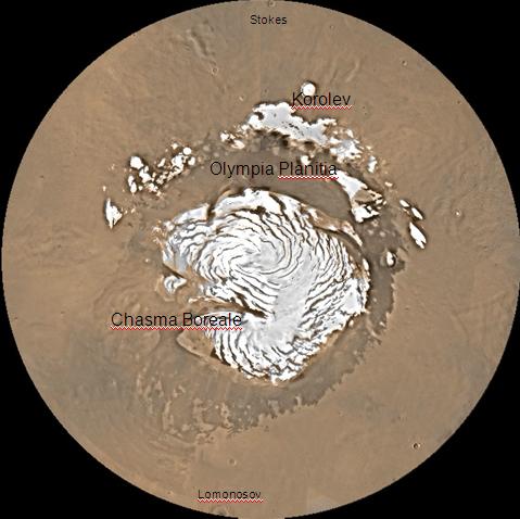
English: Map of Mare Boreum Mars quadrangle. The small, colored rectangles represent image footprints for the narrow angle camera on the Mars Global Surveyor. Some are about 1 mile wide, the otheers are about 2 miles wide. |
| Zdroj | http://www.msss.com/moc_gallery/s05_s10/mc)1.html |
| Autor | Jim Secosky (Jimmarsmars at en.wikipedia) modified NASA photo (U.S. Geological survey). |
Licence
| This file is in the public domain in the United States because it was solely created by NASA. NASA copyright policy states that "NASA material is not protected by copyright unless noted". (See Template:PD-USGov, NASA copyright policy page or JPL Image Use Policy.) | ||
 |
Warnings:
|
Původní historie souboru
Na Commons přenesl z en.wikipedia uživatel Magnus Manske pomocí nástroje CommonsHelper.
Původní stránka s popisem souboru byla zde. Všechna následující uživatelská jména odkazují na projekt en.wikipedia.
- 2008-12-22 20:16 Jimmarsmars 479×478× (35755 bytes) {{Information |Description=map of Mare Boreum Mars |Source=http://www.msss.com/moc_gallery/s05_s10/mc)1.html |Date=December 29, 2008 |Author=Jim Secosky modified NASA photo. |Permission= |other_versions= }}
Historie souboru
Kliknutím na datum a čas se zobrazí tehdejší verze souboru.
| Datum a čas | Náhled | Rozměry | Uživatel | Komentář | |
|---|---|---|---|---|---|
| současná | 20. 2. 2011, 08:31 | | 479 × 478 (35 KB) | File Upload Bot (Magnus Manske) | {{BotMoveToCommons|en.wikipedia|year={{subst:CURRENTYEAR}}|month={{subst:CURRENTMONTHNAME}}|day={{subst:CURRENTDAY}}}} {{Information |Description={{en|Map of Mare Boreum Mars quadrangle. The small, colored rectangles represent image footprints for the n |
Využití souboru
Tento soubor používá následující stránka:
Globální využití souboru
Tento soubor využívají následující wiki:
- Využití na bn.wikipedia.org
- Využití na ca.wikipedia.org
- Využití na en.wikipedia.org
- Využití na es.wikipedia.org
- Využití na eu.wikipedia.org
- Využití na fr.wikipedia.org
- Využití na hi.wikipedia.org
- Využití na hr.wikipedia.org
- Využití na lb.wikipedia.org
- Využití na pt.wikipedia.org
- Využití na sv.wikipedia.org
- Využití na uk.wikipedia.org
- Využití na zh.wikipedia.org