
Soubor:Map of Florida by John de Solís (1764).jpg

Velikost tohoto náhledu: 460 × 599 pixelů. Jiná rozlišení: 184 × 240 pixelů | 368 × 480 pixelů | 589 × 768 pixelů | 786 × 1 024 pixelů | 2 075 × 2 704 pixelů.
Původní soubor (2 075 × 2 704 pixelů, velikost souboru: 634 KB, MIME typ: image/jpeg)
| Tento soubor pochází z Wikimedia Commons. Níže jsou zobrazeny informace, které obsahuje jeho tamější stránka s popisem souboru. |
.jpg)
Popis
| Popis |
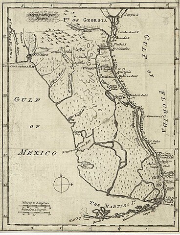
English: Map of Florida of ca. 1764]].
|
| Datum | cca 1764 |
| Zdroj | US Library of Congress |
| Autor | "Don John de Solís, surveyor, who resided there near twenty years" |
Licence
|
Toto dílo je volné také v zemích, jejichž právní řád chrání majetková autorská práva po dobu života autora a 100 let po jeho smrti. | |
| Bylo zjištěno, že u tohoto souboru nejsou známa žádná omezení daná autorským právem a právy s ním souvisejícími. | |
Historie souboru
Kliknutím na datum a čas se zobrazí tehdejší verze souboru.
| Datum a čas | Náhled | Rozměry | Uživatel | Komentář | |
|---|---|---|---|---|---|
| současná | 28. 5. 2018, 01:06 | | 2 075 × 2 704 (634 KB) | Hispalois | Higher-resolution image. Please note that this map has no relationship whatsoever with 16th-century explorer Juan Díaz de Solís. |
| 15. 6. 2006, 19:16 |  | 399 × 500 (49 KB) | Eamezaga | Map published in the US depicting a very accurate shape of Florida (1764), based on an ancient draft drawn by the Spanish-Portuguese explorer and discoverer Juan Díaz de Solís (US Library of Congress, released to public domain) |
Využití souboru
Tento soubor nepoužívá žádná stránka.
Globální využití souboru
Tento soubor využívají následující wiki:
- Využití na en.wikipedia.org
- Využití na it.wikipedia.org
.jpg)