
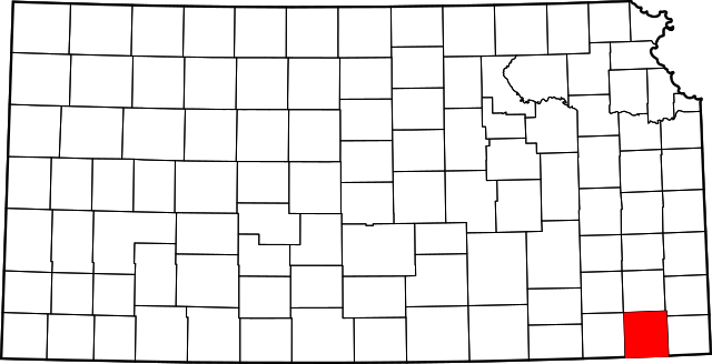
Soubor:Map of Kansas highlighting Labette County.svg

Velikost tohoto PNG náhledu tohoto SVG souboru: 800 × 410 pixelů. Jiná rozlišení: 320 × 164 pixelů | 640 × 328 pixelů | 1 024 × 525 pixelů | 1 280 × 656 pixelů | 2 560 × 1 313 pixelů | 2 202 × 1 129 pixelů.
Původní soubor (soubor SVG, nominální rozměr: 2 202 × 1 129 pixelů, velikost souboru: 21 KB)
| Tento soubor pochází z Wikimedia Commons. Níže jsou zobrazeny informace, které obsahuje jeho tamější stránka s popisem souboru. |
Popis
| Popis |
English: This is a locator map showing Labette County in Kansas. For more information, see Commons:United States county locator maps. |
| Datum | |
| Zdroj |
Vlastní dílo: English: The maps use data from nationalatlas.gov, specifically countyp020.tar.gz on the Raw Data Download page. The maps also use state outline data from statesp020.tar.gz. The Florida maps use hydrogm020.tar.gz to display Lake Okeechobee. |
| Autor | David Benbennick |
Licence
| Já, autor tohoto díla, jej tímto uvolňuji jako volné dílo, a to celosvětově. V některých zemích to není podle zákona možné; v takovém případě: Poskytuji komukoli právo užívat toto dílo za libovolným účelem, a to bezpodmínečně s výjimkou podmínek vyžadovaných zákonem. |
Historie souboru
Kliknutím na datum a čas se zobrazí tehdejší verze souboru.
| Datum a čas | Náhled | Rozměry | Uživatel | Komentář | |
|---|---|---|---|---|---|
| současná | 25. 6. 2024, 05:23 | | 2 202 × 1 129 (21 KB) | Nux | fix rendering (remove clipping) |
| 12. 2. 2006, 14:18 |  | 6 607 × 3 388 (24 KB) | David Benbennick | {{subst:User:Dbenbenn/clm|county=Labette County|state=Kansas}} |
Využití souboru
Tento soubor používá následující stránka:
Globální využití souboru
Tento soubor využívají následující wiki:
- Využití na ar.wikipedia.org
- Využití na azb.wikipedia.org
- Využití na bg.wikipedia.org
- Využití na bpy.wikipedia.org
- Využití na ca.wikipedia.org
- Využití na cdo.wikipedia.org
- Využití na ceb.wikipedia.org
- Využití na cy.wikipedia.org
- Využití na de.wikipedia.org
- Využití na en.wikipedia.org
- List of counties in Kansas
- Labette County, Kansas
- Altamont, Kansas
- Bartlett, Kansas
- Chetopa, Kansas
- Edna, Kansas
- Labette, Kansas
- Mound Valley, Kansas
- Oswego, Kansas
- Parsons, Kansas
- Angola, Kansas
- Dennis, Kansas
- Mound Valley Township, Labette County, Kansas
- Template:Labette County, Kansas
- User:Nyttend/County templates/KS/1
- National Register of Historic Places listings in Labette County, Kansas
- Category:Populated places in Labette County, Kansas
- Montana, Kansas
- Valeda, Kansas
- Mortimer, Kansas
- Využití na es.wikipedia.org
- Využití na et.wikipedia.org
- Využití na eu.wikipedia.org
- Využití na fa.wikipedia.org
- Využití na fa.wikivoyage.org
- Využití na fr.wikipedia.org
- Využití na hu.wikipedia.org
Zobrazit další globální využití tohoto souboru.