
Soubor:Map of Developed Countries (CIA World Factbook 2008).png

Velikost tohoto náhledu: 800 × 351 pixelů. Jiná rozlišení: 320 × 140 pixelů | 640 × 281 pixelů | 1 425 × 625 pixelů.
Původní soubor (1 425 × 625 pixelů, velikost souboru: 30 KB, MIME typ: image/png)
| Tento soubor pochází z Wikimedia Commons. Níže jsou zobrazeny informace, které obsahuje jeho tamější stránka s popisem souboru. |
.png)
Popis
| Popis |
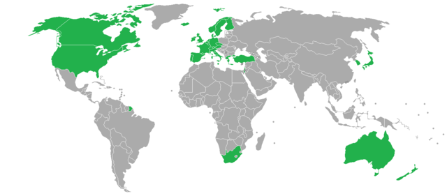
Map of Developed Countries according to the CIA World Factbook 2008 [1] Includes the French Overseas Departments and Territories which are constitutionally a part of France, as well as the overseas islands which are constitutionally a part of Spain, Portugal and Norway. |
| Datum | |
| Zdroj | Vlastní dílo |
| Autor | Res Gestæ Divi Augusti |
Licence
Já, držitel autorských práv k tomuto dílu, ho tímto zveřejňuji za podmínek následujících licencí:

|
Tento dokument smí být kopírován, šířen nebo upravován podle podmínek Svobodné licence GNU pro dokumenty verze 1.2 nebo libovolné vyšší verze publikované nadací Free Software Foundation. Dokument nemá neměnné části ani texty na předním či zadním přebalu. Kopie textu licence je k dispozici v oddíle nazvaném GNU Free Documentation License. |
This file is licensed under the Creative Commons Attribution-Share Alike 4.0 International, 3.0 Unported, 2.5 Generic, 2.0 Generic and 1.0 Generic license.
- Dílo smíte:
- šířit – kopírovat, distribuovat a sdělovat veřejnosti
- upravovat – pozměňovat, doplňovat, využívat celé nebo částečně v jiných dílech
- Za těchto podmínek:
- uveďte autora – Máte povinnost uvést autorství, poskytnout odkaz na licenci a uvést, pokud jste provedli změny. Toho můžete docílit jakýmkoli rozumným způsobem, avšak ne způsobem naznačujícím, že by poskytovatel licence schvaloval nebo podporoval vás nebo vaše užití díla.
- zachovejte licenci – Pokud tento materiál jakkoliv upravíte, přepracujete nebo použijete ve svém díle, musíte své příspěvky šířit pod stejnou nebo slučitelnou licencí jako originál.
Můžete si zvolit libovolnou z těchto licencí.
See also
Historie souboru
Kliknutím na datum a čas se zobrazí tehdejší verze souboru.
| Datum a čas | Náhled | Rozměry | Uživatel | Komentář | |
|---|---|---|---|---|---|
| současná | 21. 10. 2015, 06:54 | | 1 425 × 625 (30 KB) | Eigen1985 | update. |
| 6. 2. 2015, 09:31 |  | 1 425 × 625 (36 KB) | TristanPhoenix | Update | |
| 24. 4. 2008, 02:28 |  | 4 500 × 2 234 (304 KB) | Res Gestæ Divi Augusti~commonswiki | {{Information |Description=Map of Developed Countries according to the CIA World Factbook 2008. Includes the French Overseas Departments and Territories which are constitutionally a part of France, as well as the overseas islands which are constitutiona |
Využití souboru
Tento soubor používá následující stránka:
.png)