
Soubor:Map Kingdom of Holland 1807-nl.svg

Velikost tohoto PNG náhledu tohoto SVG souboru: 505 × 600 pixelů. Jiná rozlišení: 202 × 240 pixelů | 404 × 480 pixelů | 647 × 768 pixelů | 862 × 1 024 pixelů | 1 725 × 2 048 pixelů | 1 902 × 2 258 pixelů.
Původní soubor (soubor SVG, nominální rozměr: 1 902 × 2 258 pixelů, velikost souboru: 619 KB)
| Tento soubor pochází z Wikimedia Commons. Níže jsou zobrazeny informace, které obsahuje jeho tamější stránka s popisem souboru. |
Popis
| Popis |
[]
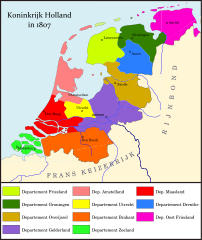
Deutsch: Königreich Holland im Jahr 1807. English: Map of the Kingdom of Holland in 1807 Español: Mapa del Reino de Holanda en 1807 Français : Carte du Royaume de Hollande en 1807 Magyar: A Holland Királyság 1807-ben Nederlands: Kaart van het Koninkrijk Holland Ελληνικά: Χάρτη του Βασιλείου της Ολλανδίας το 1807 |
|||
| Datum | ||||
| Zdroj |
Vlastní dílo
|
|||
| Autor | Joostik | |||
| Další verze |
[]
|


Licence
Já, držitel autorských práv k tomuto dílu, ho tímto zveřejňuji za podmínek následující licence:
Tento soubor podléhá licenci Creative Commons Uveďte autora-Zachovejte licenci 3.0 Unported
- Dílo smíte:
- šířit – kopírovat, distribuovat a sdělovat veřejnosti
- upravovat – pozměňovat, doplňovat, využívat celé nebo částečně v jiných dílech
- Za těchto podmínek:
- uveďte autora – Máte povinnost uvést autorství, poskytnout odkaz na licenci a uvést, pokud jste provedli změny. Toho můžete docílit jakýmkoli rozumným způsobem, avšak ne způsobem naznačujícím, že by poskytovatel licence schvaloval nebo podporoval vás nebo vaše užití díla.
- zachovejte licenci – Pokud tento materiál jakkoliv upravíte, přepracujete nebo použijete ve svém díle, musíte své příspěvky šířit pod stejnou nebo slučitelnou licencí jako originál.
Historie souboru
Kliknutím na datum a čas se zobrazí tehdejší verze souboru.
| Datum a čas | Náhled | Rozměry | Uživatel | Komentář | |
|---|---|---|---|---|---|
| současná | 10. 2. 2012, 17:40 | | 1 902 × 2 258 (619 KB) | Joostik |
Využití souboru
Tento soubor používá následující stránka:
Globální využití souboru
Tento soubor využívají následující wiki:
- Využití na ar.wikipedia.org
- Využití na arz.wikipedia.org
- Využití na ast.wikipedia.org
- Využití na be.wikipedia.org
- Využití na bg.wikipedia.org
- Využití na ca.wikipedia.org
- Využití na eo.wikipedia.org
- Využití na fa.wikipedia.org
- Využití na fy.wikipedia.org
- Využití na gl.wikipedia.org
- Využití na he.wikipedia.org
- Využití na hr.wikipedia.org
- Využití na it.wikipedia.org
- Využití na ka.wikipedia.org
- Využití na li.wikipedia.org
- Využití na mr.wikipedia.org
- Využití na ms.wikipedia.org
- Využití na nds-nl.wikipedia.org
- Využití na nl.wikipedia.org
- Koninkrijk Holland
- Lodewijk Napoleon
- Departementen in de Nederlanden
- Departement Friesland
- Departement Maasland
- Departement Amstelland
- Nederlanders
- Overleg:Platdietse streek
- Departement Overijssel
- Departement Zeeland
- Departement Drenthe
- Departement Gelderland
- Departement Utrecht
- Departement Groningen
- Departement Oost-Friesland
- Departement Brabant
- Využití na pl.wikipedia.org
- Využití na pt.wikipedia.org
- Využití na ro.wikipedia.org
- Využití na ru.wikipedia.org
- Využití na sh.wikipedia.org
- Využití na sr.wikipedia.org
Zobrazit další globální využití tohoto souboru.