
Soubor:Land given up to Silesian dukes (Dr. T. Szulc).jpg

Původní soubor (1 266 × 779 pixelů, velikost souboru: 218 KB, MIME typ: image/jpeg)
| Tento soubor pochází z Wikimedia Commons. Níže jsou zobrazeny informace, které obsahuje jeho tamější stránka s popisem souboru. |
.jpg)
| Popis |
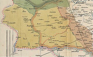
English: Part of a historical map of Greater Poland (Middle Ages) made by Dr. T. Szulc and included in the 4th volume of Codex diplomaticus Maioris Poloniae, covering a Lubusz Land and land given up to Silesian dukes by the Greatpoland dukes Polski: Fragment historycznej mapy Wielkopolski w epoce piastowskiej wykonanej przez Dr. T. Szulca i zamieszczonej w czwartym tomie Kodeksu dyplomatycznego Wielkopolski, obrazujący Ziemię Lubuską (granice diecezji lubuskiej) oraz obszar odstąpiony książętom śląskim przez książąt wielkopolskich |
| Datum | (UTC) |
| Zdroj | |
| Autor |
|
| Toto je upravený obrázek, což znamená, že byl oproti původní verzi digitálně změněn. Úpravy: Extracting part of the map to cover Lubusz Land. Původní verzi je možné zhlédnout zde: WielkoPolska epoki Piastowskiej.jpg. Úpravy provedl Opole.pl.
|
|
Toto dílo je volné také v zemích, jejichž právní řád chrání majetková autorská práva po dobu života autora a 70 let po jeho smrti.
| |
| Bylo zjištěno, že u tohoto souboru nejsou známa žádná omezení daná autorským právem a právy s ním souvisejícími. | |
Původní historie souboru
This image is a derivative work of the following images:
- File:WielkoPolska_epoki_Piastowskiej.jpg licensed with PD-old
- 2009-06-22T15:28:59Z Paelius 4075x3613 (10969409 Bytes) {{Information |Description={{en|1=Historical map of Greater Poland (Middle Ages) made by Dr. T. Szulc and included in the 4th volume of Codex diplomaticus Maioris Poloniae}} {{pl|1=Historyczna mapa Wielkopolski w epoce piasto
Uploaded with derivativeFX
Historie souboru
Kliknutím na datum a čas se zobrazí tehdejší verze souboru.
| Datum a čas | Náhled | Rozměry | Uživatel | Komentář | |
|---|---|---|---|---|---|
| současná | 14. 1. 2022, 14:32 | | 1 266 × 779 (218 KB) | Davey2010 | rv vandal - please seek consensus for your changes |
| 13. 1. 2022, 21:13 |  | 1 023 × 1 056 (362 KB) | LechitaPL | Reverted to version as of 20:25, 19 September 2021 (UTC) (vandalized) | |
| 13. 1. 2022, 03:23 |  | 1 266 × 779 (218 KB) | Davey2010 | Reverted to version as of 12:21, 19 August 2009 (UTC) | |
| 19. 9. 2021, 22:25 |  | 1 023 × 1 056 (362 KB) | LechitaPL | Zmiany | |
| 19. 8. 2009, 14:21 |  | 1 266 × 779 (218 KB) | Opole.pl | {{Information |Description={{en|1=Part of a historical map of Greater Poland (Middle Ages) made by Dr. T. Szulc and included in the 4th volume of Codex diplomaticus Maioris Poloniae, covering Lubusz Land}} {{pl|1=Fragment historycznej mapy Wielkopolski w |
Využití souboru
Tento soubor nepoužívá žádná stránka.
Globální využití souboru
Tento soubor využívají následující wiki:
- Využití na ar.wikipedia.org
- Využití na fr.wikipedia.org
- Využití na ru.wikipedia.org
.jpg)