
Soubor:Lewis and Clark National Historic Trail.PNG
Větší rozlišení není k dispozici
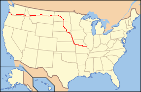
Lewis_and_Clark_National_Historic_Trail.PNG (286 × 186 pixelů, velikost souboru: 27 KB, MIME typ: image/png)
| Tento soubor pochází z Wikimedia Commons. Níže jsou zobrazeny informace, které obsahuje jeho tamější stránka s popisem souboru. |
| Popis |
English: I created this image to be used as a locator map for the Lewis and Clark National Historic Trail. |
| Datum | 11. ledna 2006 (datum prvotního načtení souboru) |
| Zdroj | Na Commons přeneseno z en.wikipedia. |
| Autor | MONGO na projektu Wikipedie v jazyce angličtina |
Licence
| MONGO na projektu Wikipedie v jazyce angličtina, autor tohoto díla, jej uvolnil jako volné dílo, a to celosvětově. V některých zemích to není podle zákona možné; v takovém případě: MONGO poskytuje komukoli právo užívat toto dílo za libovolným účelem, a to bezpodmínečně s výjimkou podmínek vyžadovaných zákonem. |
Původní historie souboru
Původní stránka s popisem souboru byla zde. Všechna následující uživatelská jména odkazují na projekt en.wikipedia.
- 2006-01-11 11:34 MONGO 286×186× (27676 bytes) I created this image to be used as a locator map for [[Lewis and Clark National Historic Trail]]
Historie souboru
Kliknutím na datum a čas se zobrazí tehdejší verze souboru.
| Datum a čas | Náhled | Rozměry | Uživatel | Komentář | |
|---|---|---|---|---|---|
| současná | 31. 5. 2015, 20:53 | | 286 × 186 (27 KB) | McZusatz | Reverted to version as of 17:53, 21 March 2009. com:DONTOVERWRITE |
| 6. 5. 2015, 04:10 |  | 13 200 × 10 200 (975 KB) | Geographyguy | Updated the Lewis and Clark Trail centerline to follow the official historic route administered by the National Park Service. | |
| 21. 3. 2009, 19:53 |  | 286 × 186 (27 KB) | Urdangaray | {{Information |Description={{en|I created this image to be used as a locator map for en:Lewis and Clark National Historic Trail}} |Source=Transferred from [http://en.wikipedia.org en.wikipedia] |Date=2006-01-11 (original upload date) |Author=Original |
Využití souboru
Tento soubor používá následující stránka:
Globální využití souboru
Tento soubor využívají následující wiki:
- Využití na de.wikipedia.org
- Využití na en.wikivoyage.org
- Využití na es.wikipedia.org
- Využití na it.wikipedia.org
- Využití na www.wikidata.org