
Soubor:Hammurabi's Babylonia Locator Map 1.svg

Velikost tohoto PNG náhledu tohoto SVG souboru: 671 × 600 pixelů. Jiná rozlišení: 269 × 240 pixelů | 537 × 480 pixelů | 859 × 768 pixelů | 1 146 × 1 024 pixelů | 2 291 × 2 048 pixelů | 744 × 665 pixelů.
Původní soubor (soubor SVG, nominální rozměr: 744 × 665 pixelů, velikost souboru: 154 KB)
| Tento soubor pochází z Wikimedia Commons. Níže jsou zobrazeny informace, které obsahuje jeho tamější stránka s popisem souboru. |
Popis
| Popis |
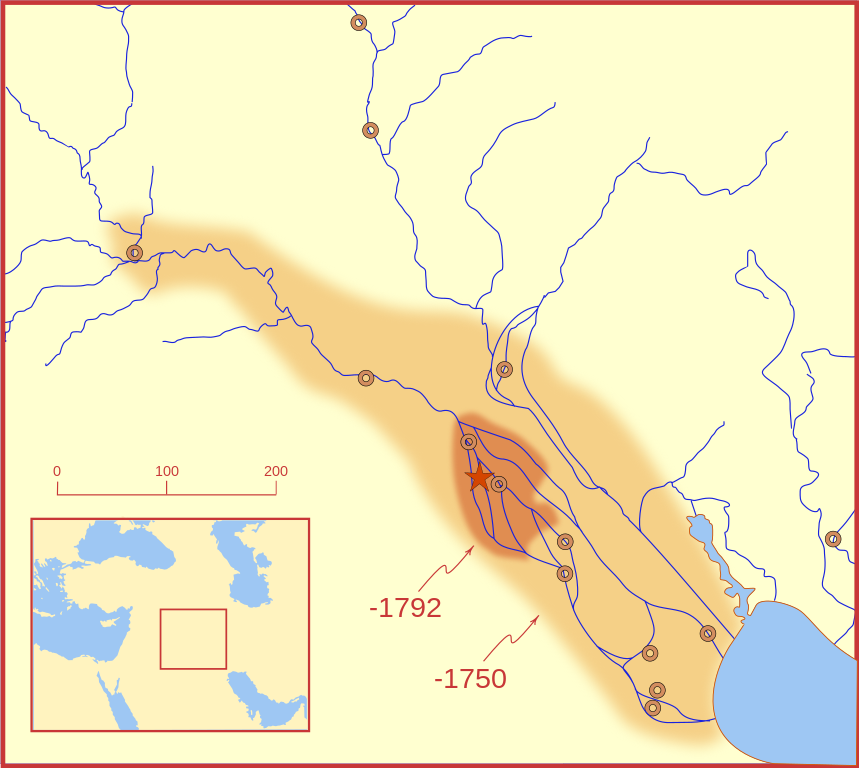
A locator map of Hammurabi's Babylonia, showing the Babylonian territory upon his ascension in 1792 BC and upon his death in 1750 BC. The river courses and coastline are those of that time period -- in general, they are not the modern rivers or coastlines. This is a Mercator projection, with north in its usual position. There is some question to what degree the cities of Nineveh, Tuttul, and Assur were under Babylonian authority. While in his introduction to his code of laws, Hammurabi claims lordship over these cities, Roaf does not include any of these in his map, upon which this map is based, and Chevalas states that "Assur and Nineveh were held for a very few years" (p. 155). Therefore, I have not included them as under Hammurabi's control in 1750 BC. |
| Datum | |
| Zdroj | Vlastní dílo |
| Autor | MapMaster |
| Další verze |
[]
|


Other versions
References
- Bjorklund, Oddvar; Holmboe, Haakon; Rohr, Anders (1970) Historical Atlas of the World, Barnes & Noble, NY, SBN: 389-00253-4.
- Chavalas, Mark W.; K. Lawson Younger (2003) Mesopotamia and the Bible, Continuum International Publishing Group, ISBN 978-0567082312.
- Hammond World Atlas Corporation (2007) Historical World Atlas, ISBN 9-780843-71391-6
- Roaf, M. (1990) Cultural Atlas of Mesopotamia and the ancient Near East, Oxford: Facts on File. (In general, the basis for the ancient river courses and ancient coastline).
- Van De Mieroop, Marc (2005). King Hammurabi of Babylon: A Biography. Blackwell Publishing. ISBN 1405126604
Licence
Já, držitel autorských práv k tomuto dílu, ho tímto zveřejňuji za podmínek následujících licencí:

|
Tento dokument smí být kopírován, šířen nebo upravován podle podmínek Svobodné licence GNU pro dokumenty verze 1.2 nebo libovolné vyšší verze publikované nadací Free Software Foundation. Dokument nemá neměnné části ani texty na předním či zadním přebalu. Kopie textu licence je k dispozici v oddíle nazvaném GNU Free Documentation License. |
This file is licensed under the Creative Commons Attribution-Share Alike Attribution-Share Alike 4.0 International, 3.0 Unported, 2.5 Generic, 2.0 Generic and 1.0 Generic license.
- Dílo smíte:
- šířit – kopírovat, distribuovat a sdělovat veřejnosti
- upravovat – pozměňovat, doplňovat, využívat celé nebo částečně v jiných dílech
- Za těchto podmínek:
- uveďte autora – Máte povinnost uvést autorství, poskytnout odkaz na licenci a uvést, pokud jste provedli změny. Toho můžete docílit jakýmkoli rozumným způsobem, avšak ne způsobem naznačujícím, že by poskytovatel licence schvaloval nebo podporoval vás nebo vaše užití díla.
- zachovejte licenci – Pokud tento materiál jakkoliv upravíte, přepracujete nebo použijete ve svém díle, musíte své příspěvky šířit pod stejnou nebo slučitelnou licencí jako originál.
Můžete si zvolit libovolnou z těchto licencí.
Historie souboru
Kliknutím na datum a čas se zobrazí tehdejší verze souboru.
| Datum a čas | Náhled | Rozměry | Uživatel | Komentář | |
|---|---|---|---|---|---|
| současná | 21. 2. 2008, 05:26 | | 744 × 665 (154 KB) | MapMaster | "blurred" the territory outlines |
| 21. 2. 2008, 01:22 |  | 744 × 665 (149 KB) | MapMaster | Changes based on a review of ''Mesopotamia and the Bible'' | |
| 21. 2. 2008, 00:10 |  | 744 × 665 (151 KB) | MapMaster | Minor edits | |
| 19. 2. 2008, 05:03 |  | 744 × 665 (150 KB) | MapMaster | Once more, with feeling | |
| 19. 2. 2008, 04:09 |  | 744 × 665 (151 KB) | MapMaster | earlier upload would not render | |
| 19. 2. 2008, 04:01 |  | 332 × 292 (333 KB) | MapMaster | {{Information |Description=A locator map of Hammurabi's Babylonia, showing the Babylonian territory upon his ascension in 1792 BC and upon his death in 1750 BC. The river courses and coastline are those of that time period -- in general, they are not the |
Využití souboru
Tento soubor používají následující 3 stránky:
Globální využití souboru
Tento soubor využívají následující wiki:
- Využití na bg.wikipedia.org
- Využití na bs.wikipedia.org
- Využití na da.wikipedia.org
- Využití na el.wikipedia.org
- Využití na eo.wikipedia.org
- Využití na et.wikipedia.org
- Využití na fi.wikipedia.org
- Využití na fr.wikipedia.org
- Využití na gl.wikipedia.org
- Využití na he.wikipedia.org
- Využití na hr.wikipedia.org
- Využití na hu.wikipedia.org
- Využití na id.wikipedia.org
- Využití na it.wikipedia.org
- Využití na ja.wikipedia.org
- Využití na jv.wikipedia.org
- Využití na lt.wikipedia.org
- Využití na lv.wikipedia.org
- Využití na nl.wikipedia.org
- Využití na no.wikipedia.org
- Využití na pl.wikipedia.org
- Využití na pt.wikipedia.org
- Využití na ro.wikipedia.org
- Využití na ru.wikipedia.org
- Využití na sh.wikipedia.org
- Využití na sl.wikipedia.org
- Využití na sq.wikipedia.org
- Využití na sv.wikipedia.org
- Využití na sw.wikipedia.org
- Využití na tr.wikipedia.org