
Soubor:Aerial photograph of Midway Atoll on 24 November 1941 (80-G-451086).jpg

Velikost tohoto náhledu: 792 × 600 pixelů. Jiná rozlišení: 317 × 240 pixelů | 634 × 480 pixelů | 1 014 × 768 pixelů | 1 280 × 969 pixelů | 2 560 × 1 939 pixelů | 4 526 × 3 428 pixelů.
Původní soubor (4 526 × 3 428 pixelů, velikost souboru: 6,09 MB, MIME typ: image/jpeg)
| Tento soubor pochází z Wikimedia Commons. Níže jsou zobrazeny informace, které obsahuje jeho tamější stránka s popisem souboru. |
.jpg)
Popis
| Fotograf |
Neznámý |
||||||||||||||||||||
| Popis |
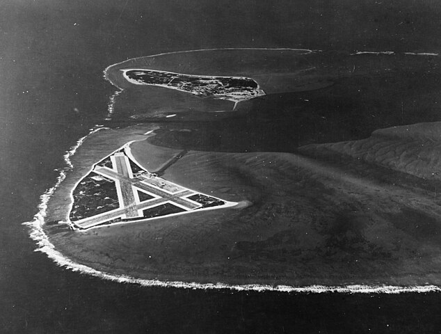
English: Aerial photograph of Midway Atoll, looking just south of west across the southern side of the atoll, 24 November 1941. Eastern Island, then the site of Midway's airfield, is in the foreground. Sand Island, location of most other base facilities, is across the entrance channel. |
||||||||||||||||||||
| Depicted place | Midway Atoll | ||||||||||||||||||||
| Datum | 24. listopadu 1941 | ||||||||||||||||||||
| Sbírka |
|
||||||||||||||||||||
| Inventární číslo |
80-G-451086 |
||||||||||||||||||||
| Zdroj | U.S. Navy photo 80-G-451086 | ||||||||||||||||||||
| Další verze | File:Aerial view of Midway Atoll on 24 November 1941 (80-G-451086).jpg | ||||||||||||||||||||
.jpg)
Licence
| This image is available from the Naval History and Heritage Command under the digital ID 80-G-451086. Most of the photos found in the NHHC collection are in the public domain and may be downloaded and used without permissions or special requirements. Those which are not will be noted in the copyright section of the NHHC image description.[1] |
This file is a work of a sailor or employee of the U.S. Navy, taken or made as part of that person's official duties. As a work of the U.S. federal government, it is in the public domain in the United States.
|
 | |
| Bylo zjištěno, že u tohoto souboru nejsou známa žádná omezení daná autorským právem a právy s ním souvisejícími. | ||
Historie souboru
Kliknutím na datum a čas se zobrazí tehdejší verze souboru.
| Datum a čas | Náhled | Rozměry | Uživatel | Komentář | |
|---|---|---|---|---|---|
| současná | 28. 10. 2015, 23:42 | | 4 526 × 3 428 (6,09 MB) | Cobatfor | new NHHC file |
| 9. 2. 2012, 23:58 |  | 680 × 740 (333 KB) | Cobatfor | caption bar cropped | |
| 22. 5. 2006, 15:21 |  | 680 × 765 (127 KB) | Ulflarsen | Caption: Midway Atoll. Aerial photograph, looking just south of west across the southern side of the atoll, 24 November 1941. Eastern Island, then the site of Midway's airfield, is in the foreground. Sand Island, location of most other base facilities, is |
Využití souboru
Tento soubor nepoužívá žádná stránka.
Globální využití souboru
Tento soubor využívají následující wiki:
- Využití na da.wikipedia.org
- Využití na el.wikipedia.org
- Využití na it.wikipedia.org
- Využití na nl.wikipedia.org
- Využití na pl.wikipedia.org
.jpg)