
Soubor:Flotillagazamapa.svg

Velikost tohoto PNG náhledu tohoto SVG souboru: 783 × 600 pixelů. Jiná rozlišení: 314 × 240 pixelů | 627 × 480 pixelů | 1 003 × 768 pixelů | 1 280 × 980 pixelů | 2 560 × 1 960 pixelů | 1 148 × 879 pixelů.
Původní soubor (soubor SVG, nominální rozměr: 1 148 × 879 pixelů, velikost souboru: 815 KB)
| Tento soubor pochází z Wikimedia Commons. Níže jsou zobrazeny informace, které obsahuje jeho tamější stránka s popisem souboru. |
Popis
| Popis |
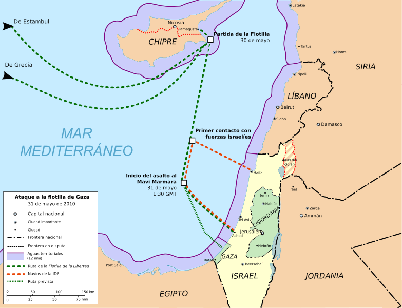
English: Freedom Flotilla incident. 31 may 2010.
Cartographic base from Open Street Maps (heavily modified) Flotilla route points from Freegaza.org (under CC by-sa)Español: Ataque a la Flotilla Libertad (ó Flotilla de Gaza) el 31 de mayo de 2010.
Base cartográfica de Open Street Maps (muy modificada) Puntos de la ruta de la Flotilla Freegaza.org (bajo licencia CC by-sa) |
| Datum | |
| Zdroj | Vlastní dílo |
| Autor | Montgomery |
| Další verze |
Díla odvozená od tohoto souboru: Gaza flotilla raid map.svg  |
Geographic limits of the map:
- N 35.66° N
- S 30.47° N
- W 29.92° E
- E 38.01° E
Scale (full extent image) 1:3.500.000
Licence
Já, držitel autorských práv k tomuto dílu, ho tímto zveřejňuji za podmínek následujících licencí:

|
Tento dokument smí být kopírován, šířen nebo upravován podle podmínek Svobodné licence GNU pro dokumenty verze 1.2 nebo libovolné vyšší verze publikované nadací Free Software Foundation. Dokument nemá neměnné části ani texty na předním či zadním přebalu. Kopie textu licence je k dispozici v oddíle nazvaném GNU Free Documentation License. |
This file is licensed under the Creative Commons Attribution-Share Alike Attribution-Share Alike 4.0 International, 3.0 Unported, 2.5 Generic, 2.0 Generic and 1.0 Generic license.
- Dílo smíte:
- šířit – kopírovat, distribuovat a sdělovat veřejnosti
- upravovat – pozměňovat, doplňovat, využívat celé nebo částečně v jiných dílech
- Za těchto podmínek:
- uveďte autora – Máte povinnost uvést autorství, poskytnout odkaz na licenci a uvést, pokud jste provedli změny. Toho můžete docílit jakýmkoli rozumným způsobem, avšak ne způsobem naznačujícím, že by poskytovatel licence schvaloval nebo podporoval vás nebo vaše užití díla.
- zachovejte licenci – Pokud tento materiál jakkoliv upravíte, přepracujete nebo použijete ve svém díle, musíte své příspěvky šířit pod stejnou nebo slučitelnou licencí jako originál.
Můžete si zvolit libovolnou z těchto licencí.
Historie souboru
Kliknutím na datum a čas se zobrazí tehdejší verze souboru.
| Datum a čas | Náhled | Rozměry | Uživatel | Komentář | |
|---|---|---|---|---|---|
| současná | 14. 11. 2012, 10:36 | | 1 148 × 879 (815 KB) | Kalgaron | FALSE, unless you can supply sources that indicate the flotilla was not headed for Gaza |
| 1. 7. 2011, 00:28 |  | 1 148 × 879 (818 KB) | Randam | Correction according to flotilla site | |
| 16. 6. 2010, 00:47 |  | 1 148 × 879 (815 KB) | Montgomery | Golan Heights (Altos del Golán) painted with stripes. Hour adjust. | |
| 10. 6. 2010, 15:59 |  | 1 148 × 879 (814 KB) | Montgomery | Adjust of territorial waters limits. Exclude contiguous zone. | |
| 10. 6. 2010, 01:28 |  | 1 148 × 879 (826 KB) | Montgomery | Map colours conventions & minor changes. | |
| 7. 6. 2010, 16:40 |  | 1 148 × 879 (917 KB) | Montgomery | minor changes | |
| 7. 6. 2010, 15:01 |  | 1 148 × 879 (1 023 KB) | Rastrojo | fixing | |
| 6. 6. 2010, 22:32 |  | 1 148 × 879 (1 016 KB) | Montgomery | {{Information |Description={{en|1=Freedom Flotilla incident. 31 may 2010. Cartographic base from Open Street Maps (heavily modified) Flotilla route points from [http://www.witnessgaza.com/ Freegaza.org] (under CC by-sa)}} {{es|1=Ataque a la Flotilla Liber |
Využití souboru
Tento soubor používá následující stránka:
Globální využití souboru
Tento soubor využívají následující wiki:
- Využití na ast.wikipedia.org
- Využití na ca.wikipedia.org
- Využití na cy.wikipedia.org
- Využití na es.wikipedia.org
- Využití na eu.wikipedia.org
- Využití na fr.wikipedia.org
- Využití na he.wikipedia.org
- Využití na ms.wikipedia.org
- Využití na pl.wikipedia.org
- Využití na pt.wikipedia.org
- Využití na th.wikipedia.org
- Využití na www.wikidata.org