
Soubor:Finland-Norway border map.png
Větší rozlišení není k dispozici
Finland-Norway_border_map.png (514 × 290 pixelů, velikost souboru: 93 KB, MIME typ: image/png)
| Tento soubor pochází z Wikimedia Commons. Níže jsou zobrazeny informace, které obsahuje jeho tamější stránka s popisem souboru. |
Popis
| Popis |
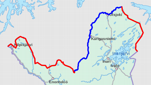
English: Schematic map of the Finland–Norway border. Land border highlighted in red and river border in blue.
Map cropped from the 1:4000000 background map provided by the NLS of Finland. Highlighted border is based on free numeric data provided by the NLS. Suomi: Karttakuva Suomen ja Norjan rajasta. Maaraja korostettu punaisella ja jokiraja sinisellä.
Karttapohja on otettu Maanmittauslaitoksen 1:4000000 taustakartasta, johon on lisätty värikorostus Maanmittauslaitoksen numeerisen aineiston avulla. |
| Datum | |
| Zdroj | https://tiedostopalvelu.maanmittauslaitos.fi/tp/kartta?lang=en |
| Autor | National Land Survey of Finland; color highlights added by Jmk |
Licence

|
This file is licensed under the National Land Survey open data licence, version 1.0 (1 May 2012) published by the National Land Survey of Finland.
You are free to:
You must, through reasonable means:
The terms of this licence do not allow you to state in conjunction with the use of dataset(s) that the NLS supports or recommends such use. |
 |
| Uveďte autora: contains map data from the National Land Survey of Finland Topographic Database 09/2012
|
Historie souboru
Kliknutím na datum a čas se zobrazí tehdejší verze souboru.
| Datum a čas | Náhled | Rozměry | Uživatel | Komentář | |
|---|---|---|---|---|---|
| současná | 9. 11. 2012, 12:12 | | 514 × 290 (93 KB) | Jmk | User created page with UploadWizard |
Využití souboru
Tento soubor používá následující stránka:
Globální využití souboru
Tento soubor využívají následující wiki:
- Využití na ckb.wikipedia.org
- Využití na de.wikipedia.org
- Využití na en.wikipedia.org
- Využití na es.wikipedia.org
- Využití na fi.wikipedia.org
- Využití na fi.wiktionary.org
- Využití na hr.wikipedia.org
- Využití na it.wikipedia.org
- Využití na sv.wikipedia.org
- Využití na uk.wikipedia.org