
Soubor:Etzlaub Landstrassen 1501.jpg

Velikost tohoto náhledu: 460 × 600 pixelů. Jiná rozlišení: 184 × 240 pixelů | 368 × 480 pixelů | 589 × 768 pixelů | 785 × 1 024 pixelů | 1 571 × 2 048 pixelů | 5 174 × 6 746 pixelů.
Původní soubor (5 174 × 6 746 pixelů, velikost souboru: 32,4 MB, MIME typ: image/jpeg)
| Tento soubor pochází z Wikimedia Commons. Níže jsou zobrazeny informace, které obsahuje jeho tamější stránka s popisem souboru. |
Popis
| Popis |
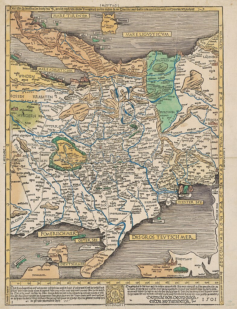
English: Map of trade routes in central Europe. Nuremberg 1501.
Deutsch: "Das sein dy lantstrassen durch das Romisch reych", Karte der Handelsstraßen in Mitteleuropa. Nürnberg 1501. |
||||||||||||||||||||||
| Datum | |||||||||||||||||||||||
| Zdroj | Harvard Mac Collection (Houghton Library copy image) | ||||||||||||||||||||||
| Autor |
|
||||||||||||||||||||||
You will find a more detailed and zoomable version here / Eine detailreichere und zoombare Version findet sich hier.
Licence
|
Toto je věrná fotografická reprodukce původního dvourozměrného uměleckého díla. Ono dílo je samo volným dílem, a to z následujícího důvodu:
Oficiálním stanoviskem nadace Wikimedia Foundation je, že „věrné reprodukce dvourozměrných volných děl jsou také volné a opačná tvrzení jsou útokem na samotný koncept volných děl.“ Podrobnosti naleznete na stránce Commons:When to use the PD-Art tag.
Tato fotografická reprodukce se tedy také považuje za volné dílo. Uvědomte si, že v závislosti na místních zákonech může být další užití tohoto díla ve vaší jurisdikci zakázáno či omezeno. Vizte Commons:Reuse of PD-Art photographs. | ||||
Historie souboru
Kliknutím na datum a čas se zobrazí tehdejší verze souboru.
| Datum a čas | Náhled | Rozměry | Uživatel | Komentář | |
|---|---|---|---|---|---|
| současná | 11. 12. 2023, 21:04 | | 5 174 × 6 746 (32,4 MB) | Don-vip | full-res from https://dezoomify.ophir.dev/#https://iiif.lib.harvard.edu/manifests/ids:2655377 |
| 11. 6. 2010, 18:38 |  | 1 675 × 2 277 (1,96 MB) | Pirkheimer | Rand abgeschnitten | |
| 11. 6. 2010, 18:16 |  | 1 928 × 2 399 (1,21 MB) | Pirkheimer | {{Information |Description={{en|1=Map of trade routes in central Europe. Nuremberg 1501.}} {{de|1="Das sein dy lantstrassen durch das Romisch reych", Karte der Handelsstraßen in Mitteleuropa. Nürnberg 1501.}} |Source=[http://nrs.harvard.edu/urn-3:FHCL:5 |
Využití souboru
Tento soubor používá následující stránka: