
Soubor:Durrani Empire 1747 1862 AD.png
Velikost tohoto náhledu: 768 × 600 pixelů. Jiná rozlišení: 307 × 240 pixelů | 615 × 480 pixelů | 832 × 650 pixelů.
Původní soubor (832 × 650 pixelů, velikost souboru: 105 KB, MIME typ: image/png)
| Tento soubor pochází z Wikimedia Commons. Níže jsou zobrazeny informace, které obsahuje jeho tamější stránka s popisem souboru. |
| Popis |
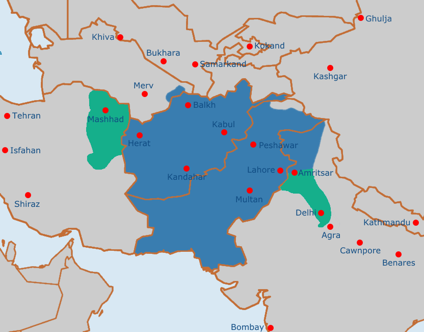
English: Map of the Afghan Durrani Empire at its greatest extent, circa late 1750s. In green is de facto (vassal) control. |
| Datum | |
| Zdroj | https://en.wikipedia.org/wiki/File:Safavid_Empire_1501_1722_AD.png |
| Autor | Arab Hafez and edited by me. |
This file is in the public domain because Released into the public domain by the author.
|
Historie souboru
Kliknutím na datum a čas se zobrazí tehdejší verze souboru.
| Datum a čas | Náhled | Rozměry | Uživatel | Komentář | |
|---|---|---|---|---|---|
| současná | 4. 8. 2021, 13:51 | | 832 × 650 (105 KB) | Weaveravel | De facto/vessel control and corrected Mashhad/Khorasan |
| 4. 8. 2021, 13:39 |  | 832 × 650 (108 KB) | Weaveravel | Improved map layout and scale, added Delhi territory (as de facto control), fixed cities geographical positions | |
| 26. 7. 2021, 20:54 |  | 1 415 × 958 (205 KB) | Weaveravel | Clearer, high quality map, more accurate labels and cities (denoting important ones) | |
| 28. 4. 2013, 16:27 |  | 620 × 429 (22 KB) | HistoryofIran | {{subst:Upload marker added by en.wp UW}} {{Information |Description = {{en|Map of the Durrani Empire at it's greatest extent.}} |Source = https://en.wikipedia.org/wiki/File:Safavid_Empire_1501_1722_AD.png |Date = 28. April 2013. |Author = Arab Hafez a... |
Využití souboru
Tento soubor používá následující stránka:
Globální využití souboru
Tento soubor využívají následující wiki:
- Využití na ar.wikipedia.org
- Využití na ast.wikipedia.org
- Využití na azb.wikipedia.org
- Využití na az.wikipedia.org
- Využití na bg.wikipedia.org
- Využití na bn.wikipedia.org
- Využití na bs.wikipedia.org
- Využití na ca.wikipedia.org
- Využití na de.wikipedia.org
- Využití na diq.wikipedia.org
- Využití na el.wikipedia.org
- Využití na en.wikipedia.org
- Využití na eo.wikipedia.org
- Využití na es.wikipedia.org
- Využití na et.wikipedia.org
- Využití na eu.wikipedia.org
- Využití na fa.wikipedia.org
- Využití na fi.wikipedia.org
- Využití na fr.wikipedia.org
- Využití na he.wikipedia.org
- Využití na hi.wikipedia.org
- Využití na hu.wikipedia.org
- Využití na hy.wikipedia.org
- Využití na it.wikipedia.org
- Využití na ka.wikipedia.org
- Využití na kn.wikipedia.org
- Využití na lt.wikipedia.org
- Využití na mn.wikipedia.org
- Využití na nl.wikipedia.org
- Využití na nn.wikipedia.org
- Využití na pt.wikipedia.org
- Využití na ru.wikipedia.org
- Využití na sk.wikipedia.org
- Využití na sv.wikipedia.org
- Využití na ta.wikipedia.org
- Využití na tg.wikipedia.org
- Využití na vi.wikipedia.org
- Využití na www.wikidata.org
Zobrazit další globální využití tohoto souboru.