
Soubor:Concord Expedition and Patriot Messengers.jpg

Velikost tohoto náhledu: 800 × 341 pixelů. Jiná rozlišení: 320 × 136 pixelů | 1 000 × 426 pixelů.
Původní soubor (1 000 × 426 pixelů, velikost souboru: 139 KB, MIME typ: image/jpeg)
| Tento soubor pochází z Wikimedia Commons. Níže jsou zobrazeny informace, které obsahuje jeho tamější stránka s popisem souboru. |

|
Tento soubor byl nahrazen souborem File:Concord Expedition and Patriot Messengers-en.svg. Je doporučeno používat nový soubor.
|

|
K tomuto obrázku existuje vektorová verze (v SVG). Pokud je lepší, používejte raději tu.
File:Concord Expedition and Patriot Messengers.jpg → File:Concord Expedition and Patriot Messengers-en.svg
Podrobnější informace o vektorové grafice najdete na stránce Commons:Transition to SVG. Také si můžete přečíst informace o podpoře formátu SVG v MediaWiki. |
 |
Popis
| Titul |
angličtina:
Routes of the British Expedition and the Patriot Messengers |
||||||||||||||||||||
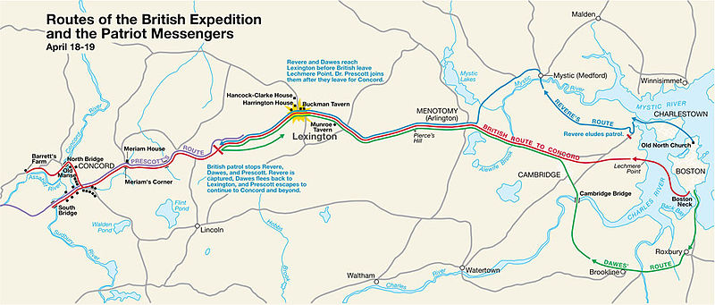
| Popis |
Paul Revere's Midnight Ride English: This is a map depiction the outbound routes taken by Patriot riders and British troops in the Battles of Lexington and Concord on April 19, 1775. |
||||||||||||||||||||
| Map legend |
British route to Concord Revere's route Dawes' route Prescott's route |
||||||||||||||||||||
| Datum | neznámé datum; source PDF was created in 2000 | ||||||||||||||||||||
| Zdroj | MIMAmap2.pdf 10. května 2005 (upload date) od w:Flying Jazz (diskuse | příspěvky) | ||||||||||||||||||||
| Tvůrce |
Neznámý for National Park Service |
||||||||||||||||||||
| Geotemporal data | |||||||||||||||||||||
| Zobrazené datum | |||||||||||||||||||||
| Map location | Boston, Massachusetts | ||||||||||||||||||||
| Map type | thematic map | ||||||||||||||||||||
| Heading |
 |
||||||||||||||||||||
| Georeferencing | If inappropriate please set warp_status = skip to hide. | ||||||||||||||||||||
| Bibliographic data | |||||||||||||||||||||
| Vydavatel |
National Park Service |
||||||||||||||||||||
| Archival data | |||||||||||||||||||||
| Sbírka |
|
||||||||||||||||||||
| Vnitřní znaky |
Název : Routes of the British Expedition and the Patriot Messengers
Text :
Revere and Dawes reach Lexington before British leave Lechmere Point. Dr. Prescott joins them after they leave for Concord.
Text :
British patrol stops Revere, Dawes, and Prescott. Revere is captured, Dawes flees back to Lexington, and Prescott escapes to continue to Concord and beyond.
|
||||||||||||||||||||
| Další verze |
|
||||||||||||||||||||


Licence
| This image or media file contains material based on a work of a National Park Service employee, created as part of that person's official duties. As a work of the U.S. federal government, such work is in the public domain in the United States. See the NPS website and NPS copyright policy for more information. |
Původní historie souboru
Na Commons přenesl z en.wikipedia uživatel Andrei Stroe pomocí nástroje CommonsHelper.
Původní stránka s popisem souboru byla zde. Všechna následující uživatelská jména odkazují na projekt en.wikipedia.
- 2005-05-10 09:58 Flying Jazz 1000×426× (141988 bytes) Routes of the British Expedition and the Patriot Messengers April 18-19 (1775) Minute Man National Historical Park Battle Map http://data2.itc.nps.gov/parks/mima/ppMaps/MIMAmap2.pdf {{PD-USGov-Interior-NPS}}
- 2005-05-10 09:54 Flying Jazz 1000×426× (141988 bytes) Minute Man National Historical Park Battle Map http://data2.itc.nps.gov/parks/mima/ppMaps/MIMAmap2.pdf {{PD-USGov-Interior-NPS}}
Historie souboru
Kliknutím na datum a čas se zobrazí tehdejší verze souboru.
| Datum a čas | Náhled | Rozměry | Uživatel | Komentář | |
|---|---|---|---|---|---|
| současná | 22. 11. 2010, 22:50 | | 1 000 × 426 (139 KB) | File Upload Bot (Magnus Manske) | {{BotMoveToCommons|en.wikipedia|year={{subst:CURRENTYEAR}}|month={{subst:CURRENTMONTHNAME}}|day={{subst:CURRENTDAY}}}} {{Information |Description={{en|This is a map depiction the outbound routes taken by Patriot ride |
Využití souboru
Tento soubor používá následující stránka:
Globální využití souboru
Tento soubor využívají následující wiki:
- Využití na azb.wikipedia.org
- Využití na en.wikipedia.org
- Využití na fr.wikipedia.org
- Využití na it.wikipedia.org
- Využití na ro.wikipedia.org
- Využití na ru.wikipedia.org
- Využití na th.wikipedia.org
- Využití na zh.wikipedia.org