
Soubor:Aberdeenshire UK blank map.svg

Velikost tohoto PNG náhledu tohoto SVG souboru: 682 × 600 pixelů. Jiná rozlišení: 273 × 240 pixelů | 546 × 480 pixelů | 873 × 768 pixelů | 1 165 × 1 024 pixelů | 2 329 × 2 048 pixelů | 1 425 × 1 253 pixelů.
Původní soubor (soubor SVG, nominální rozměr: 1 425 × 1 253 pixelů, velikost souboru: 1,12 MB)
| Tento soubor pochází z Wikimedia Commons. Níže jsou zobrazeny informace, které obsahuje jeho tamější stránka s popisem souboru. |
| Popis |
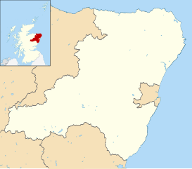
Blank map of Aberdeenshire, UK with districts shown. Equirectangular map projection on WGS 84 datum, with N/S stretched 180% Geographic limits:
|
| Datum | |
| Zdroj | Ordnance Survey OpenData. Most data from Boundary-Line product. Lake data from Meridian 2 product. Inset derived from File:Scotland location map.svg by NordNordWest. |
| Autor | Nilfanion, created using Ordnance Survey data |
| Svolení (Užití tohoto souboru) |
Tento soubor podléhá licenci Creative Commons Uveďte autora-Zachovejte licenci 3.0 Unported Uveďte autora: Contains Ordnance Survey data © Crown copyright and database right
|
Historie souboru
Kliknutím na datum a čas se zobrazí tehdejší verze souboru.
| Datum a čas | Náhled | Rozměry | Uživatel | Komentář | |
|---|---|---|---|---|---|
| současná | 22. 8. 2010, 10:29 | | 1 425 × 1 253 (1,12 MB) | Nilfanion | {{Information |Description=Blank map of Aberdeenshire, UK with districts shown. Equirectangular map projection on WGS 84 datum, with N/S stretched 180% Geographic limits: *West: 3.85W *East: 1.70W *North: 57.75N *South: 56.70N |Sourc |
Využití souboru
Tento soubor používá následující stránka: